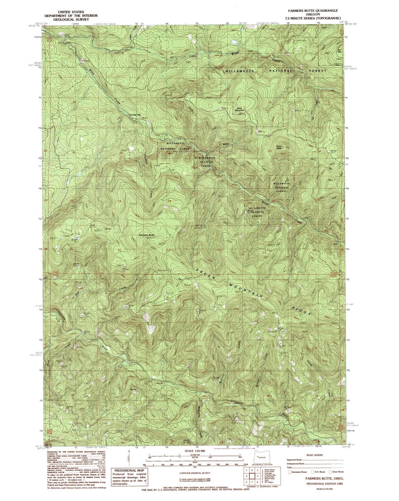
Farmers Butte Topo Map Oregon
To zoom in, hover over the map of Farmers Butte
USGS Topo Quad 44122c5 - 1:24,000 scale
| Topo Map Name: | Farmers Butte |
| USGS Topo Quad ID: | 44122c5 |
| Print Size: | ca. 21 1/4" wide x 27" high |
| Southeast Coordinates: | 44.25° N latitude / 122.5° W longitude |
| Map Center Coordinates: | 44.3125° N latitude / 122.5625° W longitude |
| U.S. State: | OR |
| Filename: | o44122c5.jpg |
| Download Map JPG Image: | Farmers Butte topo map 1:24,000 scale |
| Map Type: | Topographic |
| Topo Series: | 7.5´ |
| Map Scale: | 1:24,000 |
| Source of Map Images: | United States Geological Survey (USGS) |
| Alternate Map Versions: |
Farmers Butte OR 1988, updated 1988 Download PDF Buy paper map Farmers Butte OR 1997, updated 2001 Download PDF Buy paper map Farmers Butte OR 2011 Download PDF Buy paper map Farmers Butte OR 2014 Download PDF Buy paper map |
| FStopo: | US Forest Service topo Farmers Butte is available: Download FStopo PDF Download FStopo TIF |
1:24,000 Topo Quads surrounding Farmers Butte
Onehorse Slough |
Lacomb |
Keel Mountain |
Yellowstone Mountain |
Quartzville |
Waterloo |
Sweet Home |
Green Peter |
Cascadia |
Upper Soda |
Crawfordsville |
Chandler Mountain |
Farmers Butte |
Swamp Mountain |
Tidbits Mountain |
Marcola |
Mount Nebo |
Vida |
Mount Hagan |
Blue River |
Walterville |
Leaburg |
Goat Mountain |
Nimrod |
Harvey Mountain |
> Back to 44122a1 at 1:100,000 scale
> Back to 44122a1 at 1:250,000 scale
> Back to U.S. Topo Maps home
Farmers Butte topo map: Gazetteer
Farmers Butte: Parks
DeArmond Park elevation 332m 1089′Farmers Butte: Streams
Barrell Creek elevation 399m 1309′Bigs Creek elevation 289m 948′
Blue Creek elevation 299m 980′
Cedar Creek elevation 276m 905′
Fall Creek elevation 471m 1545′
Farmers Creek elevation 298m 977′
Hands Creek elevation 409m 1341′
Little Wiley Creek elevation 240m 787′
McKinley Creek elevation 351m 1151′
Washout Creek elevation 365m 1197′
Farmers Butte: Summits
Buck Mountain elevation 920m 3018′Doe Mountain elevation 806m 2644′
Farmers Butte elevation 1101m 3612′
Green Butte elevation 1065m 3494′
Farmers Butte digital topo map on disk
Buy this Farmers Butte topo map showing relief, roads, GPS coordinates and other geographical features, as a high-resolution digital map file on DVD: