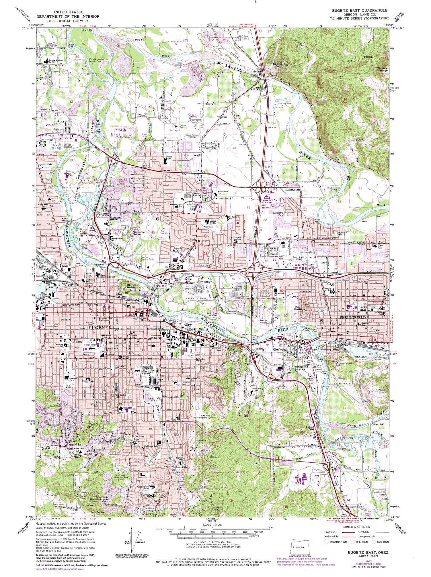
Eugene East Topo Map Oregon
To zoom in, hover over the map of Eugene East
USGS Topo Quad 44123a1 - 1:24,000 scale
| Topo Map Name: | Eugene East |
| USGS Topo Quad ID: | 44123a1 |
| Print Size: | ca. 21 1/4" wide x 27" high |
| Southeast Coordinates: | 44° N latitude / 123° W longitude |
| Map Center Coordinates: | 44.0625° N latitude / 123.0625° W longitude |
| U.S. State: | OR |
| Filename: | o44123a1.jpg |
| Download Map JPG Image: | Eugene East topo map 1:24,000 scale |
| Map Type: | Topographic |
| Topo Series: | 7.5´ |
| Map Scale: | 1:24,000 |
| Source of Map Images: | United States Geological Survey (USGS) |
| Alternate Map Versions: |
Eugene East OR 1967 Download PDF Buy paper map Eugene East OR 1967, updated 1970 Download PDF Buy paper map Eugene East OR 1967, updated 1977 Download PDF Buy paper map Eugene East OR 1975, updated 1979 Download PDF Buy paper map Eugene East OR 2011 Download PDF Buy paper map Eugene East OR 2014 Download PDF Buy paper map |
1:24,000 Topo Quads surrounding Eugene East
Monroe |
Harrisburg |
Indian Head |
Union Point |
Crawfordsville |
Cheshire |
Junction City |
Coburg |
Mohawk |
Marcola |
Veneta |
Eugene West |
Eugene East |
Springfield |
Walterville |
Crow |
Fox Hollow |
Creswell |
Jasper |
Lowell |
Letz Creek |
Lorane |
Cottage Grove |
Dorena Lake |
Kloster Mountain |
> Back to 44123a1 at 1:100,000 scale
> Back to 44122a1 at 1:250,000 scale
> Back to U.S. Topo Maps home
Eugene East topo map: Gazetteer
Eugene East: Airports
Bohemia Incorporated Airfield elevation 128m 419′McKenzie-Willamette Hospital Heliport elevation 141m 462′
Sacred Heart Medical Center Heliport elevation 131m 429′
Eugene East: Bars
Skinners Bar elevation 120m 393′Two Sisters Bar elevation 117m 383′
Eugene East: Bays
Osprey Bay elevation 134m 439′Eugene East: Bridges
Ferry Street Bridge elevation 122m 400′Greenway Bike Bridge elevation 120m 393′
Knickerbocker Bike Bridge elevation 127m 416′
Owosso Bike Bridge elevation 117m 383′
Eugene East: Canals
McKenzie Ditch elevation 133m 436′Q Street Canal elevation 135m 442′
Eugene East: Cliffs
Judkins Point elevation 192m 629′Eugene East: Gaps
Coryell Pass elevation 158m 518′Eugene East: Guts
Dedrick Slough elevation 123m 403′Eugene East: Islands
Day Island elevation 129m 423′Goodpasture Island (historical) elevation 120m 393′
Maple Island (historical) elevation 128m 419′
Eugene East: Parks
Alton Baker City Park elevation 133m 436′Alton Baker/Eastgate Woodlands elevation 131m 429′
Amazon Ball Fields elevation 129m 423′
Amazon City Park elevation 132m 433′
Armitage County Park elevation 130m 426′
Ascot City Park elevation 130m 426′
Autzen Stadium elevation 128m 419′
Blanton Ridge City Park elevation 308m 1010′
Bloomberg City Park elevation 200m 656′
Bond Lane City Park elevation 127m 416′
Brewer City Park elevation 126m 413′
By-Gully Bike/Jog Path elevation 135m 442′
Cal Young Sports Park elevation 127m 416′
Charnel Mulligan City Park elevation 130m 426′
Country Lane City Park elevation 129m 423′
Crescent City Park elevation 129m 423′
Crest Heights City Park elevation 262m 859′
Delta Ponds City Park elevation 120m 393′
Dorris Ranch Living History Farm elevation 140m 459′
East Bank City Park elevation 121m 396′
Edgewood City Park elevation 190m 623′
Eugene Civic Stadium elevation 133m 436′
Fairmount City Park elevation 146m 479′
Franklin City Park elevation 131m 429′
Friendly City Park elevation 139m 456′
Gamebird Park elevation 134m 439′
Garfield City Park elevation 123m 403′
Gateway City Park elevation 123m 403′
Gilham City Park elevation 125m 410′
Gillespie Butte City Park elevation 186m 610′
Glen Oak City Park elevation 173m 567′
Guy Lee Park elevation 134m 439′
Hamlin Sports Complex elevation 137m 449′
Harlow Road Park elevation 134m 439′
Harvest Landing elevation 137m 449′
Hendricks City Park elevation 222m 728′
Island Park elevation 135m 442′
James Park elevation 136m 446′
Jefferson City Park elevation 129m 423′
Kelly Butte Park and Overlook elevation 153m 501′
Kincaid City Park elevation 140m 459′
Kiwanis Park elevation 128m 419′
Lafferty City Park elevation 210m 688′
Laurel Hill City Park elevation 161m 528′
Lincoln School City Park elevation 128m 419′
Marche Chase City Park elevation 131m 429′
Martin Luther King Junior City Park elevation 126m 413′
Maurie Jacobs City Park elevation 126m 413′
Meadow Park elevation 138m 452′
Menlo Park elevation 134m 439′
Millrace Park elevation 135m 442′
Milton City Park elevation 150m 492′
Mission City Park elevation 174m 570′
Monroe City Park elevation 128m 419′
Moon Mountain City Park elevation 295m 967′
Oakmont City Park elevation 128m 419′
Owens Rose Garden City Park elevation 127m 416′
Page Park elevation 139m 456′
Pioneer Memorial Park elevation 148m 485′
Riverwood Park elevation 125m 410′
Road Park elevation 134m 439′
Robin Park elevation 135m 442′
Royal Delle Park elevation 136m 446′
Scobert Gardens City Park elevation 127m 416′
Shadow Wood City Park elevation 152m 498′
Sheldon Sports Park elevation 129m 423′
Skinner Butte City Park elevation 201m 659′
Skyline Park elevation 230m 754′
Sladden City Park elevation 126m 413′
Sorrel Way City Park elevation 124m 406′
South Ridge City Park elevation 317m 1040′
Tandy Turn City Park elevation 129m 423′
Tugman City Park elevation 141m 462′
University City Park elevation 138m 452′
Washburne City Park elevation 146m 479′
Washington City Park elevation 138m 452′
Washington/Jefferson City Park elevation 129m 423′
Wayne Morse Ranch City Park elevation 188m 616′
West Bank City Park elevation 125m 410′
West University City Park elevation 131m 429′
Westmoreland City Park elevation 126m 413′
Whitely Landing County Park elevation 114m 374′
Willamalane Park elevation 141m 462′
Willamette Heights Park elevation 232m 761′
Willis City Park elevation 179m 587′
Eugene East: Populated Places
College Hill elevation 191m 626′Eugene elevation 130m 426′
Glenwood elevation 135m 442′
North Springfield elevation 137m 449′
Springfield elevation 140m 459′
Eugene East: Post Offices
College Crest Post Office (historical) elevation 178m 583′Eugene Post Office elevation 130m 426′
Fairmount Post Office (historical) elevation 136m 446′
McKenzie Post Office (historical) elevation 130m 426′
Southside Post Office elevation 136m 446′
Springfield Post Office elevation 141m 462′
University Post Office elevation 138m 452′
West Side Post Office elevation 126m 413′
Willamette Forks Post Office (historical) elevation 125m 410′
Eugene East: Streams
Berkshire Slough elevation 135m 442′Coast Fork Willamette River elevation 133m 436′
Dodson Slough elevation 116m 380′
Middle Fork Willamette River elevation 133m 436′
Mill Race elevation 125m 410′
Oxley Slough elevation 137m 449′
Patterson Slough elevation 123m 403′
Russel Creek elevation 135m 442′
Eugene East: Summits
Gillespie Butte elevation 186m 610′Kelly Butte elevation 196m 643′
Moon Mountain elevation 300m 984′
Skinner Butte elevation 204m 669′
Spores Point elevation 337m 1105′
Eugene East: Swamps
Merriams Slough (historical) elevation 126m 413′Eugene East digital topo map on disk
Buy this Eugene East topo map showing relief, roads, GPS coordinates and other geographical features, as a high-resolution digital map file on DVD: