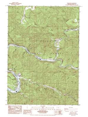
Mapleton Topo Map Oregon
To zoom in, hover over the map of Mapleton
USGS Topo Quad 44123a7 - 1:24,000 scale
| Topo Map Name: | Mapleton |
| USGS Topo Quad ID: | 44123a7 |
| Print Size: | ca. 21 1/4" wide x 27" high |
| Southeast Coordinates: | 44° N latitude / 123.75° W longitude |
| Map Center Coordinates: | 44.0625° N latitude / 123.8125° W longitude |
| U.S. State: | OR |
| Filename: | o44123a7.jpg |
| Download Map JPG Image: | Mapleton topo map 1:24,000 scale |
| Map Type: | Topographic |
| Topo Series: | 7.5´ |
| Map Scale: | 1:24,000 |
| Source of Map Images: | United States Geological Survey (USGS) |
| Alternate Map Versions: |
Mapleton OR 1984, updated 1984 Download PDF Buy paper map Mapleton OR 2011 Download PDF Buy paper map Mapleton OR 2014 Download PDF Buy paper map |
| FStopo: | US Forest Service topo Mapleton is available: Download FStopo PDF Download FStopo TIF |
1:24,000 Topo Quads surrounding Mapleton
> Back to 44123a1 at 1:100,000 scale
> Back to 44122a1 at 1:250,000 scale
> Back to U.S. Topo Maps home
Mapleton topo map: Gazetteer
Mapleton: Falls
The Horn elevation 72m 236′Mapleton: Mines
Camp Quarry elevation 150m 492′Mapleton: Parks
Deadwood Landing County Park elevation 70m 229′Mapleton Landing County Park elevation 5m 16′
Schindler Landing County Park elevation 58m 190′
Tide Wayside elevation 76m 249′
Mapleton: Populated Places
Deadwood elevation 79m 259′Mapleton elevation 5m 16′
Rainrock elevation 16m 52′
Swisshome elevation 65m 213′
Mapleton: Post Offices
Deadwood Post Office elevation 79m 259′Mapleton Post Office elevation 5m 16′
Swisshome Post Office elevation 65m 213′
Mapleton: Rapids
Davis Rapids elevation 13m 42′Mapleton: Reservoirs
Erskine Log Pond elevation 20m 65′Mapleton: Springs
Lichtenthaler Spring elevation 31m 101′Mapleton: Streams
Boyle Creek elevation 112m 367′Bridge Creek elevation 54m 177′
Brush Creek elevation 48m 157′
Camp Creek elevation 28m 91′
Cleveland Creek elevation 18m 59′
Corn Creek elevation 35m 114′
Count Creek elevation 25m 82′
Deadwood Creek elevation 74m 242′
Dinner Creek elevation 71m 232′
East Fork Brush Creek elevation 72m 236′
Elk Creek elevation 88m 288′
Green Creek elevation 69m 226′
Hadsall Creek elevation 5m 16′
Hollenbeck Creek elevation 16m 52′
Indian Creek elevation 56m 183′
Jackson Creek elevation 25m 82′
Knowles Creek elevation 5m 16′
La Bar Creek elevation 24m 78′
Lake Creek elevation 34m 111′
Martin Creek elevation 10m 32′
Old Man Creek elevation 36m 118′
Park Creek elevation 10m 32′
Plowman Creek elevation 18m 59′
Rice Creek elevation 7m 22′
Snell Creek elevation 12m 39′
Thompson Creek elevation 11m 36′
Tilden Creek elevation 58m 190′
Velvet Creek elevation 72m 236′
Mapleton: Summits
Bald Mountain elevation 397m 1302′Mapleton: Valleys
Rock Canyon elevation 68m 223′Mapleton digital topo map on disk
Buy this Mapleton topo map showing relief, roads, GPS coordinates and other geographical features, as a high-resolution digital map file on DVD:


