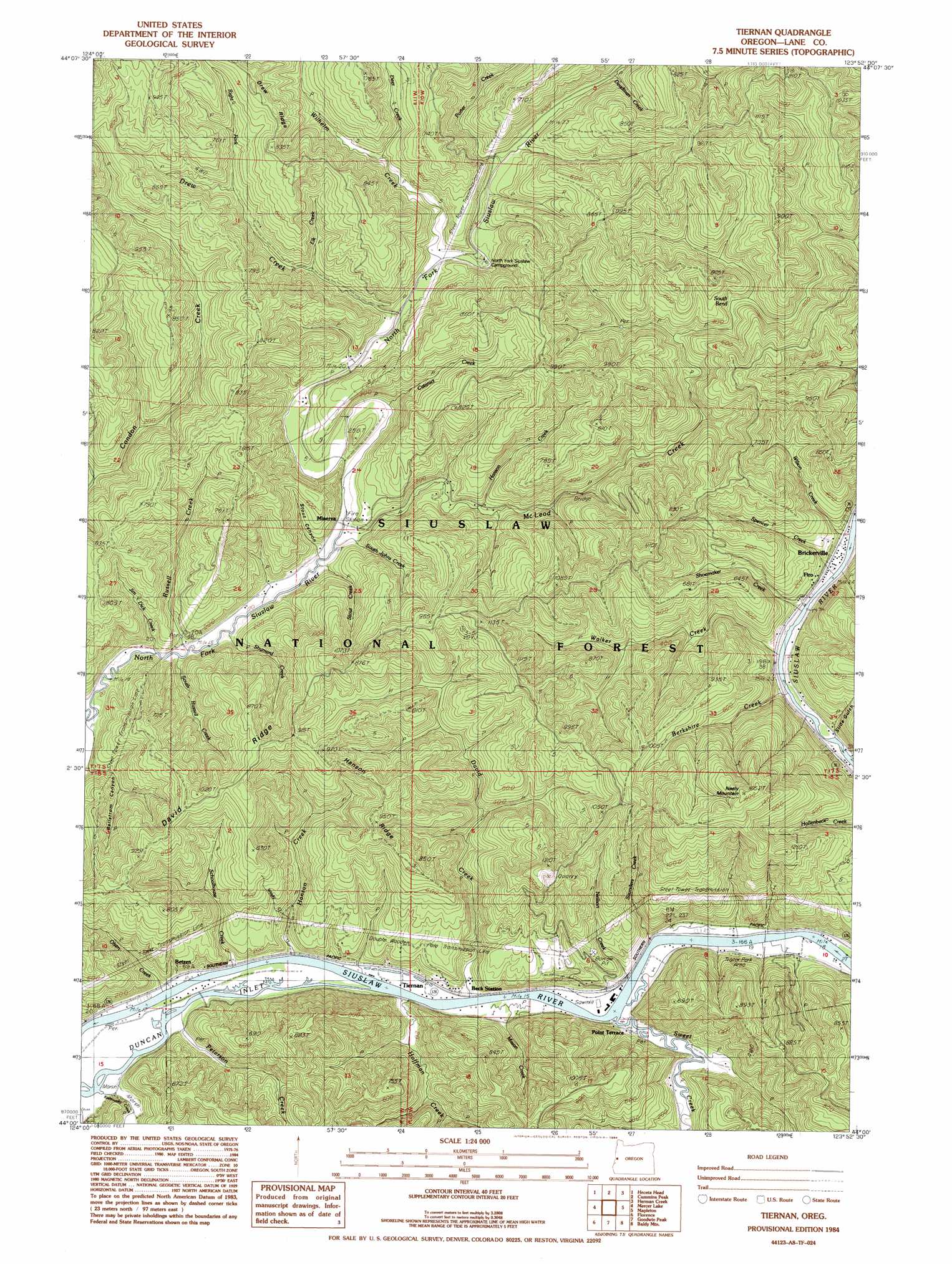
Tiernan Topo Map Oregon
To zoom in, hover over the map of Tiernan
USGS Topo Quad 44123a8 - 1:24,000 scale
| Topo Map Name: | Tiernan |
| USGS Topo Quad ID: | 44123a8 |
| Print Size: | ca. 21 1/4" wide x 27" high |
| Southeast Coordinates: | 44° N latitude / 123.875° W longitude |
| Map Center Coordinates: | 44.0625° N latitude / 123.9375° W longitude |
| U.S. State: | OR |
| Filename: | o44123a8.jpg |
| Download Map JPG Image: | Tiernan topo map 1:24,000 scale |
| Map Type: | Topographic |
| Topo Series: | 7.5´ |
| Map Scale: | 1:24,000 |
| Source of Map Images: | United States Geological Survey (USGS) |
| Alternate Map Versions: |
Tiernan OR 1984, updated 1984 Download PDF Buy paper map Tiernan OR 2011 Download PDF Buy paper map Tiernan OR 2014 Download PDF Buy paper map |
| FStopo: | US Forest Service topo Tiernan is available: Download FStopo PDF Download FStopo TIF |
1:24,000 Topo Quads surrounding Tiernan
Yachats |
Cannibal Mountain |
Five Rivers |
Digger Mountain |
|
Heceta Head |
Cummins Peak |
Herman Creek |
Windy Peak |
|
Mercer Lake |
Tiernan |
Mapleton |
Greenleaf |
|
Goose Pasture |
Florence |
Goodwin Peak |
Baldy Mountain |
Roman Nose Mountain |
Tahkenitch Creek |
Fivemile Creek |
North Fork |
Smith River Falls |
Twin Sisters |
> Back to 44123a1 at 1:100,000 scale
> Back to 44122a1 at 1:250,000 scale
> Back to U.S. Topo Maps home
Tiernan topo map: Gazetteer
Tiernan: Bends
South Bend McLeod Creek elevation 102m 334′Tiernan: Parks
Farnham Landing County Park elevation 5m 16′Tiernan: Populated Places
Brickerville elevation 9m 29′Minerva elevation 10m 32′
Point Terrace elevation 7m 22′
Tiernan elevation 10m 32′
Tiernan: Post Offices
Minerva Post Office (historical) elevation 10m 32′Point Terrace Post Office (historical) elevation 7m 22′
Seaton Post Office (historical) elevation 10m 32′
Tiernan Post Office (historical) elevation 10m 32′
Tiernan: Ridges
David Ridge elevation 318m 1043′Drew Ridge elevation 260m 853′
Hanson Ridge elevation 283m 928′
Misery Ridge elevation 216m 708′
Tiernan: Streams
Barber Creek elevation 6m 19′Berkshire Creek elevation 6m 19′
Cataract Creek elevation 49m 160′
David Creek elevation 5m 16′
Deadman Creek elevation 50m 164′
Deer Creek elevation 187m 613′
Drew Creek elevation 29m 95′
Elk Creek elevation 25m 82′
Hanson Creek elevation 6m 19′
Hoffman Creek elevation 7m 22′
Horseshoe Creek elevation 7m 22′
Jim Dick Creek elevation 8m 26′
Karnowsky Creek elevation 8m 26′
Mason Creek elevation 5m 16′
McLeod Creek elevation 9m 29′
Neilson Creek elevation 6m 19′
Olsen Creek elevation 6m 19′
Peterson Creek elevation 7m 22′
Porter Creek elevation 42m 137′
Right Fork Drew Creek elevation 84m 275′
Russell Creek elevation 8m 26′
Saunders Creek elevation 5m 16′
Schoolhouse Creek elevation 6m 19′
Shoemaker Creek elevation 8m 26′
Shumard Creek elevation 134m 439′
Slide Creek elevation 6m 19′
South Johns Creek elevation 8m 26′
South Russell Creek elevation 9m 29′
Spencer Creek elevation 6m 19′
Stout Creek elevation 8m 26′
Sweet Creek elevation 5m 16′
Uncle Creek elevation 34m 111′
Walker Creek elevation 7m 22′
Whiskey Creek elevation 36m 118′
Wilhelm Creek elevation 33m 108′
Wilson Creek elevation 7m 22′
Tiernan: Summits
Neely Mountain elevation 493m 1617′Tiernan: Valleys
Bellstrom Canyon elevation 32m 104′Slide Gulch elevation 70m 229′
Stout Canyon elevation 10m 32′
Tiernan digital topo map on disk
Buy this Tiernan topo map showing relief, roads, GPS coordinates and other geographical features, as a high-resolution digital map file on DVD: