Cheshire Topo Map Oregon
To zoom in, hover over the map of Cheshire
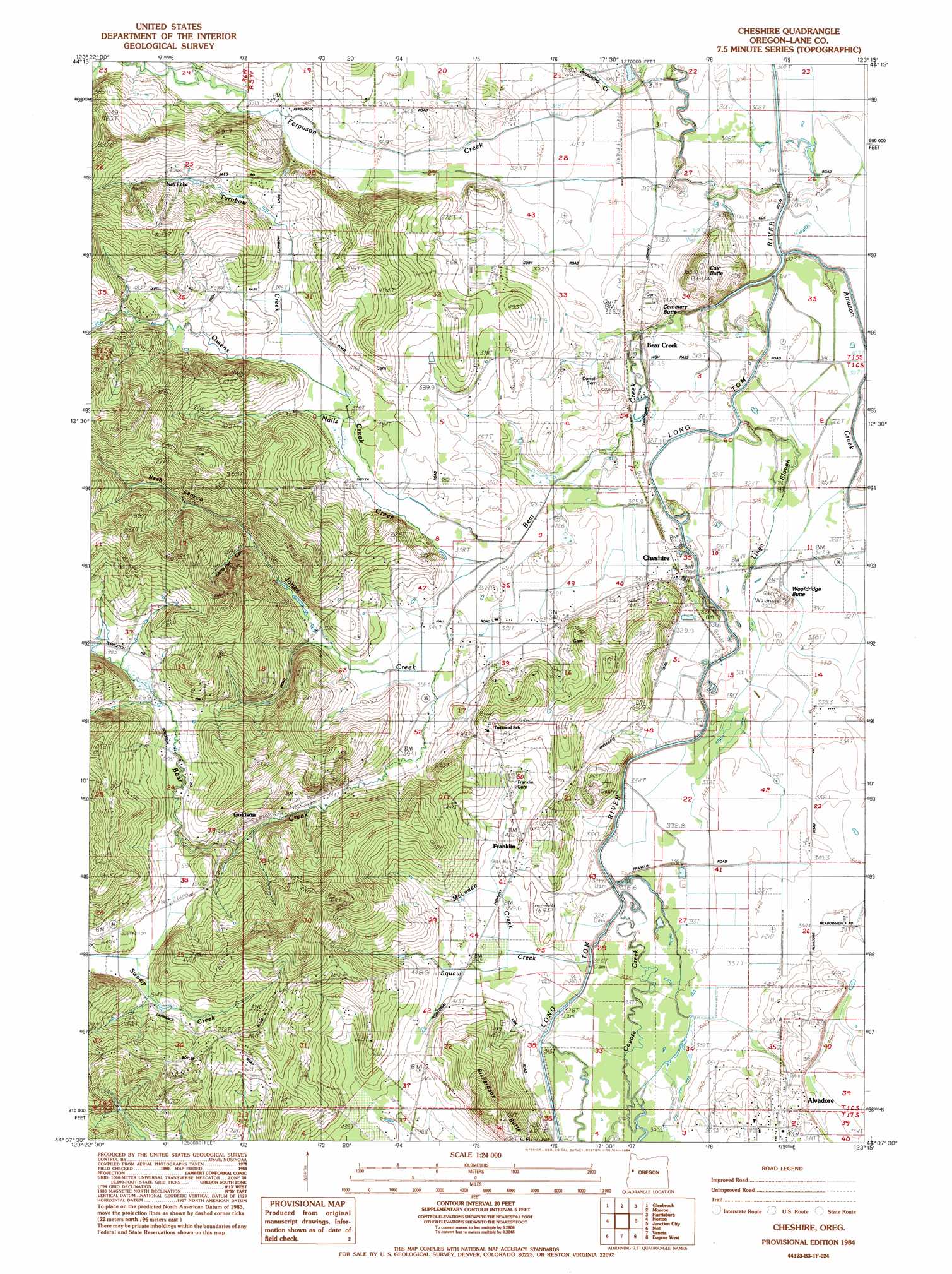
USGS Topo Quad 44123b3 - 1:24,000 scale
| Topo Map Name: | Cheshire |
| USGS Topo Quad ID: | 44123b3 |
| Print Size: | ca. 21 1/4" wide x 27" high |
| Southeast Coordinates: | 44.125° N latitude / 123.25° W longitude |
| Map Center Coordinates: | 44.1875° N latitude / 123.3125° W longitude |
| U.S. State: | OR |
| Filename: | o44123b3.jpg |
| Download Map JPG Image: | Cheshire topo map 1:24,000 scale |
| Map Type: | Topographic |
| Topo Series: | 7.5´ |
| Map Scale: | 1:24,000 |
| Source of Map Images: | United States Geological Survey (USGS) |
| Alternate Map Versions: |
Cheshire OR 1984, updated 1984 Download PDF Buy paper map Cheshire OR 2011 Download PDF Buy paper map Cheshire OR 2014 Download PDF Buy paper map |
1:24,000 Topo Quads surrounding Cheshire
Alsea |
Flat Mountain |
Greenberry |
Peoria |
Halsey |
Prairie Peak |
Glenbrook |
Monroe |
Harrisburg |
Indian Head |
Triangle Lake |
Horton |
Cheshire |
Junction City |
Coburg |
Walton |
Noti |
Veneta |
Eugene West |
Eugene East |
Clay Creek |
High Point |
Crow |
Fox Hollow |
Creswell |
> Back to 44123a1 at 1:100,000 scale
> Back to 44122a1 at 1:250,000 scale
> Back to U.S. Topo Maps home
Cheshire topo map: Gazetteer
Cheshire: Airports
Drews Airstrip elevation 102m 334′Cheshire: Lakes
Neil Lake elevation 140m 459′Cheshire: Populated Places
Alvadore elevation 118m 387′Cheshire elevation 103m 337′
Franklin elevation 147m 482′
Goldson elevation 123m 403′
Cheshire: Post Offices
Alvadore Post Office elevation 118m 387′Cheshire Post Office elevation 103m 337′
Franklin Post Office (historical) elevation 147m 482′
Goldson Post Office (historical) elevation 123m 403′
Piney Post Office (historical) elevation 144m 472′
Cheshire: Springs
Barrett Spring elevation 252m 826′Cheshire: Streams
Amazon Creek elevation 99m 324′Bear Creek elevation 97m 318′
Browning Creek elevation 94m 308′
Jones Creek elevation 102m 334′
Lingo Slough elevation 95m 311′
McLaden Creek elevation 107m 351′
Nails Creek elevation 102m 334′
Owens Creek elevation 101m 331′
Squaw Creek elevation 103m 337′
Turnbow Creek elevation 116m 380′
Cheshire: Summits
Cemetery Butte elevation 116m 380′Cox Butte elevation 181m 593′
Richardson Butte elevation 192m 629′
Wooldridge Butte elevation 103m 337′
Cheshire: Valleys
Chris Fur Canyon elevation 129m 423′Nash Canyon elevation 129m 423′
Cheshire digital topo map on disk
Buy this Cheshire topo map showing relief, roads, GPS coordinates and other geographical features, as a high-resolution digital map file on DVD: