Albany Topo Map Oregon
To zoom in, hover over the map of Albany
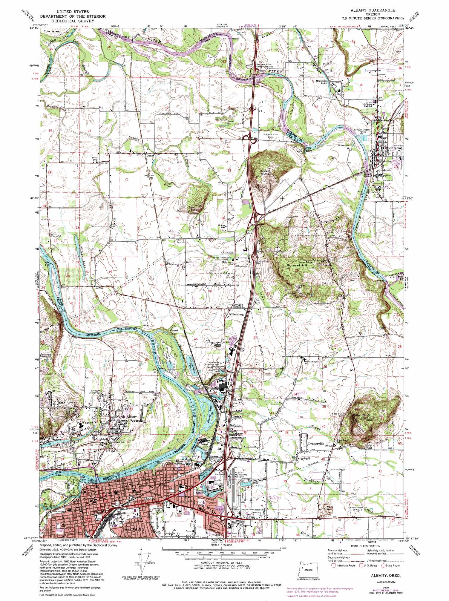
USGS Topo Quad 44123f1 - 1:24,000 scale
| Topo Map Name: | Albany |
| USGS Topo Quad ID: | 44123f1 |
| Print Size: | ca. 21 1/4" wide x 27" high |
| Southeast Coordinates: | 44.625° N latitude / 123° W longitude |
| Map Center Coordinates: | 44.6875° N latitude / 123.0625° W longitude |
| U.S. State: | OR |
| Filename: | o44123f1.jpg |
| Download Map JPG Image: | Albany topo map 1:24,000 scale |
| Map Type: | Topographic |
| Topo Series: | 7.5´ |
| Map Scale: | 1:24,000 |
| Source of Map Images: | United States Geological Survey (USGS) |
| Alternate Map Versions: |
Albany OR 1970, updated 1972 Download PDF Buy paper map Albany OR 1970, updated 1978 Download PDF Buy paper map Albany OR 1970, updated 1991 Download PDF Buy paper map Albany OR 1976, updated 1980 Download PDF Buy paper map Albany OR 2011 Download PDF Buy paper map Albany OR 2014 Download PDF Buy paper map |
1:24,000 Topo Quads surrounding Albany
Dallas |
Rickreall |
Salem West |
Salem East |
Stayton Ne |
Airlie North |
Monmouth |
Sidney |
Turner |
Stayton |
Airlie South |
Lewisburg |
Albany |
Crabtree |
Scio |
Corvallis |
Riverside |
Tangent |
Lebanon |
Onehorse Slough |
Greenberry |
Peoria |
Halsey |
Brownsville |
Waterloo |
> Back to 44123e1 at 1:100,000 scale
> Back to 44122a1 at 1:250,000 scale
> Back to U.S. Topo Maps home
Albany topo map: Gazetteer
Albany: Airports
Albany Municipal Airport elevation 69m 226′Propst Airfield elevation 72m 236′
Woolridge Airstrip elevation 61m 200′
Albany: Cliffs
The Cliff elevation 84m 275′Albany: Guts
Cole Slough elevation 53m 173′Albany: Lakes
First Lake elevation 57m 187′Fourth Lake elevation 53m 173′
Meridian Lake elevation 63m 206′
Second Lake elevation 57m 187′
Swan Lakes elevation 64m 209′
Third Lake elevation 55m 180′
Thornton Lake elevation 58m 190′
Timber-Linn Lake elevation 68m 223′
Waverly Lake elevation 61m 200′
Wilson Lake elevation 55m 180′
Albany: Parks
Bryant Park elevation 57m 187′Burkhart Park elevation 68m 223′
Takena Park elevation 70m 229′
Willamette Memorial Park elevation 77m 252′
Albany: Populated Places
Albany elevation 65m 213′Draperville elevation 70m 229′
Jefferson elevation 70m 229′
Millersburg elevation 75m 246′
North Albany elevation 60m 196′
Santiam City (historical) elevation 64m 209′
Albany: Post Offices
Albany Post Office elevation 64m 209′Enterprise Post Office (historical) elevation 66m 216′
Hoffman Post Office (historical) elevation 62m 203′
Jefferson Post Office elevation 70m 229′
Millers Post Office (historical) elevation 75m 246′
Syracuse Post Office (historical) elevation 65m 213′
Albany: Streams
Burkhart Creek elevation 61m 200′Calapooia River elevation 55m 180′
Cox Creek elevation 68m 223′
Crooks Creek elevation 56m 183′
Morgan Creek elevation 59m 193′
Murder Creek elevation 59m 193′
North Santiam River elevation 66m 216′
Periwinkle Creek elevation 55m 180′
South Santiam River elevation 66m 216′
Truax Creek elevation 59m 193′
Albany: Summits
Hale Butte elevation 132m 433′Knox Butte elevation 197m 646′
Scravel Hill elevation 159m 521′
Albany digital topo map on disk
Buy this Albany topo map showing relief, roads, GPS coordinates and other geographical features, as a high-resolution digital map file on DVD: