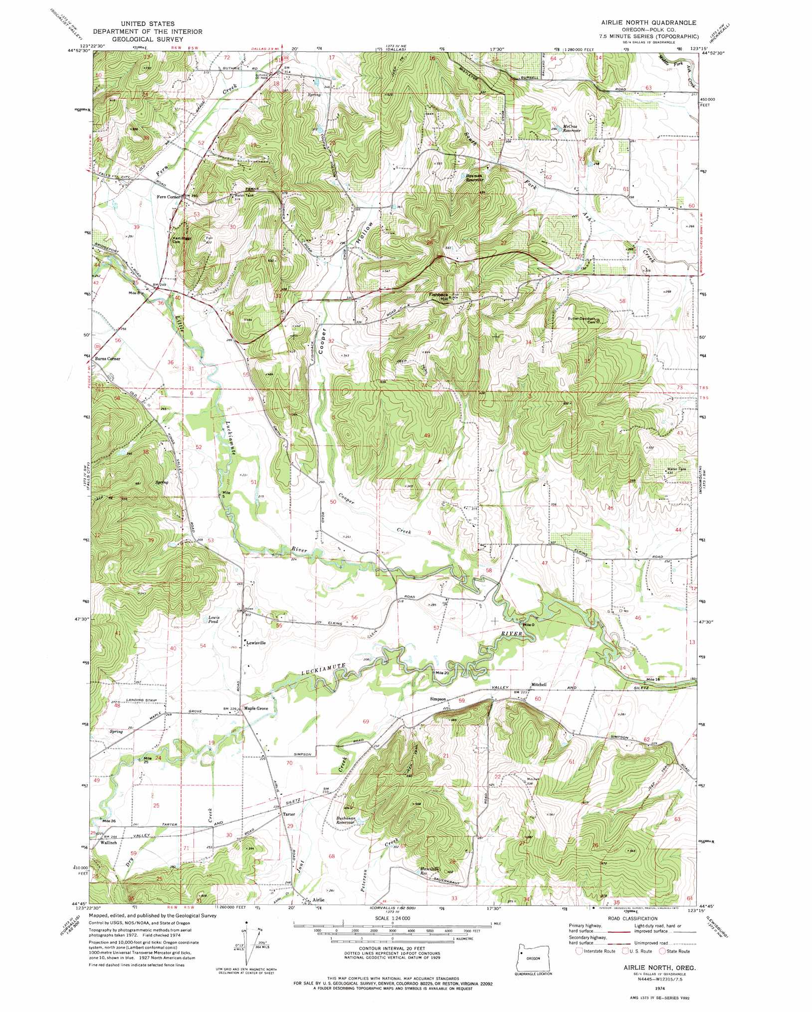
Airlie North Topo Map Oregon
To zoom in, hover over the map of Airlie North
USGS Topo Quad 44123g3 - 1:24,000 scale
| Topo Map Name: | Airlie North |
| USGS Topo Quad ID: | 44123g3 |
| Print Size: | ca. 21 1/4" wide x 27" high |
| Southeast Coordinates: | 44.75° N latitude / 123.25° W longitude |
| Map Center Coordinates: | 44.8125° N latitude / 123.3125° W longitude |
| U.S. State: | OR |
| Filename: | o44123g3.jpg |
| Download Map JPG Image: | Airlie North topo map 1:24,000 scale |
| Map Type: | Topographic |
| Topo Series: | 7.5´ |
| Map Scale: | 1:24,000 |
| Source of Map Images: | United States Geological Survey (USGS) |
| Alternate Map Versions: |
Airlie North OR 1974, updated 1977 Download PDF Buy paper map Airlie North OR 2011 Download PDF Buy paper map Airlie North OR 2014 Download PDF Buy paper map |
1:24,000 Topo Quads surrounding Airlie North
Grand Ronde |
Sheridan |
Ballston |
Amity |
Mission Bottom |
Laurel Mountain |
Socialist Valley |
Dallas |
Rickreall |
Salem West |
Fanno Ridge |
Falls City |
Airlie North |
Monmouth |
Sidney |
Summit |
Kings Valley |
Airlie South |
Lewisburg |
Albany |
Marys Peak |
Wren |
Corvallis |
Riverside |
Tangent |
> Back to 44123e1 at 1:100,000 scale
> Back to 44122a1 at 1:250,000 scale
> Back to U.S. Topo Maps home
Airlie North topo map: Gazetteer
Airlie North: Airports
Marr Field elevation 83m 272′Airlie North: Lakes
Lamer Pond elevation 109m 357′Lewis Pond elevation 86m 282′
Airlie North: Parks
Guthrie Community Park elevation 94m 308′Airlie North: Populated Places
Airlie elevation 79m 259′Ferns (historical) elevation 86m 282′
Lewisville elevation 83m 272′
Putnam (historical) elevation 66m 216′
Airlie North: Post Offices
Airlie Post Office (historical) elevation 79m 259′Bridgeport Post Office (historical) elevation 75m 246′
Lackemute Post Office (historical) elevation 62m 203′
Lewisville Post Office (historical) elevation 83m 272′
Maple Grove Post Office (historical) elevation 70m 229′
Polk Post Office (historical) elevation 81m 265′
Airlie North: Reservoirs
Alsip Reservoir elevation 115m 377′Bass Reservoir elevation 89m 291′
Bauman Reservoir elevation 106m 347′
Bowen Reservoir elevation 113m 370′
Buchanan Reservoir elevation 93m 305′
Fisher Reservoir elevation 124m 406′
Garber Reservoir elevation 105m 344′
Hamilton Reservoir elevation 91m 298′
Lenhard Reservoir elevation 167m 547′
McCrae Reservoir elevation 93m 305′
McGuire Reservoir elevation 79m 259′
Oberg Reservoir elevation 83m 272′
Pond A elevation 87m 285′
Ratzlaff Reservoir elevation 84m 275′
Winegar Reservoir elevation 65m 213′
Airlie North: Streams
Airlie Creek elevation 75m 246′Cooper Creek elevation 66m 216′
Dry Creek elevation 68m 223′
Fern Creek elevation 72m 236′
Jont Creek elevation 65m 213′
Little Luckiamute River elevation 62m 203′
Airlie North: Summits
Fishback Hill elevation 241m 790′Airlie North: Valleys
Cooper Hollow elevation 71m 232′Gilliam Swale elevation 86m 282′
Airlie North digital topo map on disk
Buy this Airlie North topo map showing relief, roads, GPS coordinates and other geographical features, as a high-resolution digital map file on DVD: