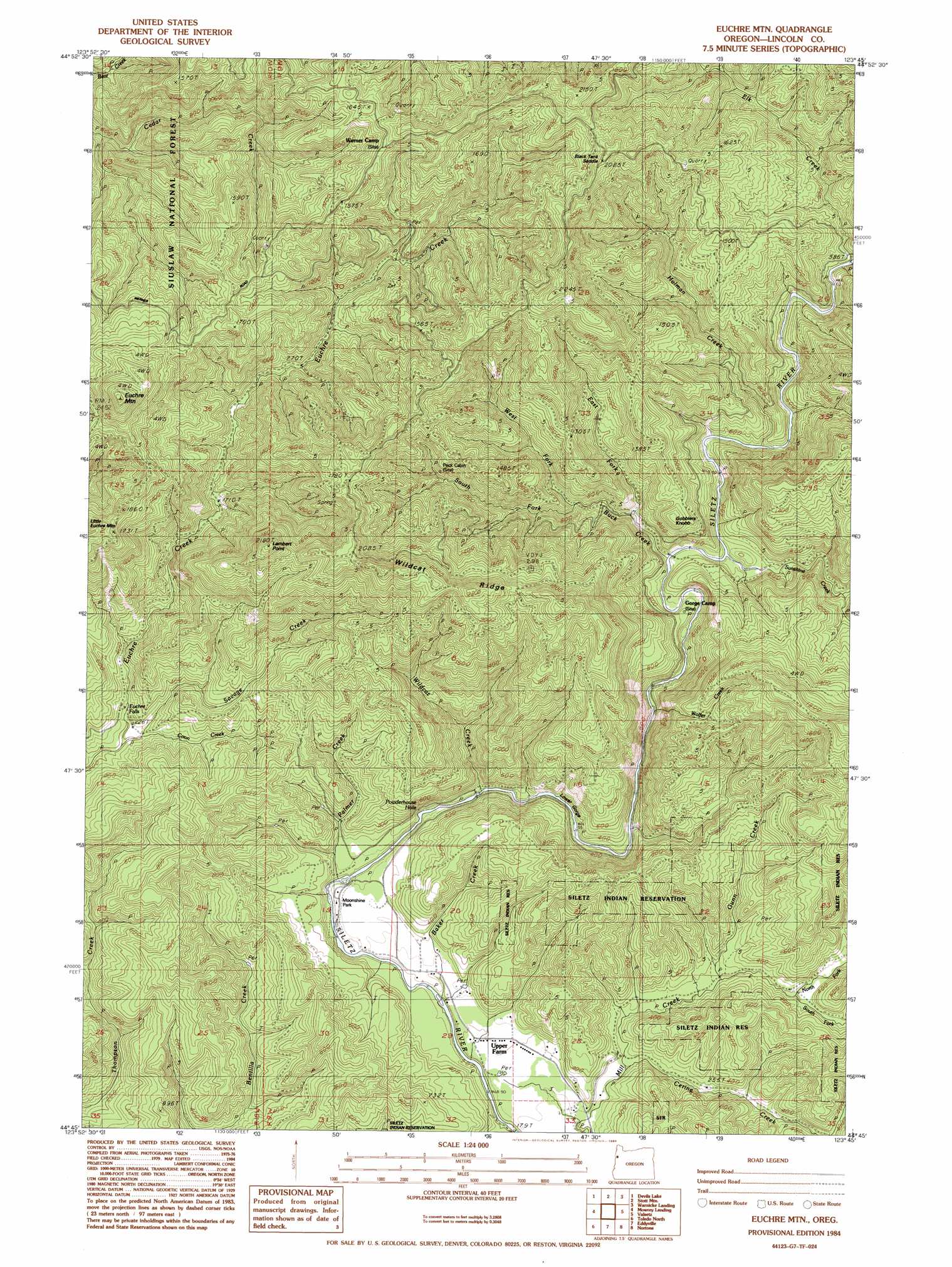
Euchre Mountain Topo Map Oregon
To zoom in, hover over the map of Euchre Mountain
USGS Topo Quad 44123g7 - 1:24,000 scale
| Topo Map Name: | Euchre Mountain |
| USGS Topo Quad ID: | 44123g7 |
| Print Size: | ca. 21 1/4" wide x 27" high |
| Southeast Coordinates: | 44.75° N latitude / 123.75° W longitude |
| Map Center Coordinates: | 44.8125° N latitude / 123.8125° W longitude |
| U.S. State: | OR |
| Filename: | o44123g7.jpg |
| Download Map JPG Image: | Euchre Mountain topo map 1:24,000 scale |
| Map Type: | Topographic |
| Topo Series: | 7.5´ |
| Map Scale: | 1:24,000 |
| Source of Map Images: | United States Geological Survey (USGS) |
| Alternate Map Versions: |
Euchre Mtn OR 1984, updated 1984 Download PDF Buy paper map Euchre Mountain OR 2011 Download PDF Buy paper map Euchre Mountain OR 2014 Download PDF Buy paper map |
| FStopo: | US Forest Service topo Euchre Mountain is available: Download FStopo PDF Download FStopo TIF |
1:24,000 Topo Quads surrounding Euchre Mountain
Neskowin |
Dolph |
Midway |
Grand Ronde |
|
Lincoln City |
Devils Lake |
Stott Mountain |
Warnicke Creek |
Laurel Mountain |
Depoe Bay |
Mowrey Landing |
Euchre Mountain |
Valsetz |
Fanno Ridge |
Newport North |
Toledo North |
Eddyville |
Nortons |
Summit |
Newport South |
Toledo South |
Elk City |
Harlan |
Marys Peak |
> Back to 44123e1 at 1:100,000 scale
> Back to 44122a1 at 1:250,000 scale
> Back to U.S. Topo Maps home
Euchre Mountain topo map: Gazetteer
Euchre Mountain: Bends
Powderhouse Hole elevation 81m 265′Euchre Mountain: Falls
Euchre Falls elevation 89m 291′Euchre Mountain: Gaps
Black Tank Saddle elevation 611m 2004′Euchre Mountain: Parks
Moonshine County Park elevation 77m 252′Euchre Mountain: Post Offices
Sugarloaf Post Office (historical) elevation 311m 1020′Euchre Mountain: Ridges
Wildcat Ridge elevation 526m 1725′Euchre Mountain: Streams
Baker Creek elevation 62m 203′Buck Creek elevation 141m 462′
Cerine Creek elevation 68m 223′
Coon Creek elevation 64m 209′
East Fork Buck Creek elevation 169m 554′
Elk Creek elevation 193m 633′
Gunn Creek elevation 81m 265′
Holman Creek elevation 158m 518′
North Fork Mill Creek elevation 85m 278′
Palmer Creek elevation 72m 236′
Savage Creek elevation 52m 170′
South Fork Buck Creek elevation 187m 613′
South Fork Mill Creek elevation 86m 282′
Sunshine Creek elevation 144m 472′
West Fork Buck Creek elevation 185m 606′
Wildcat Creek elevation 90m 295′
Wolfer Creek elevation 123m 403′
Euchre Mountain: Summits
Euchre Mountain elevation 742m 2434′Gobblers Knob elevation 341m 1118′
Lambert Point elevation 657m 2155′
Little Euchre Mountain elevation 586m 1922′
Euchre Mountain: Valleys
Lower Gorge elevation 84m 275′Euchre Mountain digital topo map on disk
Buy this Euchre Mountain topo map showing relief, roads, GPS coordinates and other geographical features, as a high-resolution digital map file on DVD: