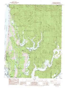
Mercer Lake Topo Map Oregon
To zoom in, hover over the map of Mercer Lake
USGS Topo Quad 44124a1 - 1:24,000 scale
| Topo Map Name: | Mercer Lake |
| USGS Topo Quad ID: | 44124a1 |
| Print Size: | ca. 21 1/4" wide x 27" high |
| Southeast Coordinates: | 44° N latitude / 124° W longitude |
| Map Center Coordinates: | 44.0625° N latitude / 124.0625° W longitude |
| U.S. State: | OR |
| Filename: | o44124a1.jpg |
| Download Map JPG Image: | Mercer Lake topo map 1:24,000 scale |
| Map Type: | Topographic |
| Topo Series: | 7.5´ |
| Map Scale: | 1:24,000 |
| Source of Map Images: | United States Geological Survey (USGS) |
| Alternate Map Versions: |
Mercer Lake OR 1984, updated 1984 Download PDF Buy paper map Mercer Lake OR 2011 Download PDF Buy paper map Mercer Lake OR 2014 Download PDF Buy paper map |
| FStopo: | US Forest Service topo Mercer Lake is available: Download FStopo PDF Download FStopo TIF |
1:24,000 Topo Quads surrounding Mercer Lake
> Back to 44124a1 at 1:100,000 scale
> Back to 44124a1 at 1:250,000 scale
> Back to U.S. Topo Maps home
Mercer Lake topo map: Gazetteer
Mercer Lake: Areas
Three Mile Prairie elevation 27m 88′Mercer Lake: Bays
Dahlin Arm elevation 10m 32′Dowell Arm elevation 10m 32′
Mercer Lake: Bridges
Funke Bridge elevation 9m 29′Mercer Lake: Capes
Cannery Point elevation 24m 78′Dowells Peninsula elevation 17m 55′
Mercer Lake: Cliffs
The Slide elevation 330m 1082′Mercer Lake: Guts
Duncan Inlet elevation 7m 22′Mercer Lake: Lakes
Ackerley Lake elevation 30m 98′Alder Lake elevation 37m 121′
Buck Lake elevation 37m 121′
Clear Lake elevation 30m 98′
Collard Lake elevation 36m 118′
Dune Lake elevation 37m 121′
Heceta Junction Lake elevation 35m 114′
Lake Marr elevation 19m 62′
Lily Lake elevation 6m 19′
Mercer Lake elevation 10m 32′
Munsel Lake elevation 28m 91′
Mussel Lake elevation 42m 137′
Nott Lake elevation 40m 131′
Sutton Lake elevation 10m 32′
Mercer Lake: Parks
Bender Landing County Park elevation 8m 26′Darlingtonia State Natural Site elevation 32m 104′
Dune Lake Park elevation 37m 121′
Harbor Vista County Park elevation 19m 62′
Houghton Landing County Park elevation 10m 32′
Mercer Lake County Park elevation 17m 55′
Munsel Landing County Park elevation 32m 104′
Mercer Lake: Populated Places
Mercer (historical) elevation 72m 236′Mercer Lake: Post Offices
Linneus Post Office (historical) elevation 15m 49′Mercer Post Office (historical) elevation 72m 236′
Mercer Lake: Ridges
Clover Ridge elevation 566m 1856′Mercer Lake: Springs
Kilmer Spring elevation 65m 213′Mercer Lake: Streams
Ackerley Creek elevation 29m 95′Ackerley Creek elevation 28m 91′
Bailey Creek elevation 11m 36′
Berry Creek elevation 5m 16′
Billie Creek elevation 17m 55′
Clear Creek elevation 30m 98′
Collard Creek elevation 32m 104′
Condon Creek elevation 9m 29′
Coon Creek elevation 47m 154′
Culver Creek elevation 8m 26′
Dahlin Creek elevation 11m 36′
Haring Creek elevation 8m 26′
Levage Creek elevation 11m 36′
Lindsley Creek elevation 9m 29′
Mercer Creek elevation 15m 49′
Mitchell Creek elevation 10m 32′
Morris Creek elevation 8m 26′
Quarry Creek elevation 6m 19′
Rath Creek elevation 12m 39′
Slover Creek elevation 10m 32′
Mercer Lake: Summits
Cannery Hill elevation 21m 68′Cape Mountain elevation 455m 1492′
Herman Peak elevation 635m 2083′
Mercer Lake: Swamps
Fosback Marsh elevation 12m 39′Mercer Lake: Valleys
Enchanted Valley elevation 11m 36′Mercer Lake digital topo map on disk
Buy this Mercer Lake topo map showing relief, roads, GPS coordinates and other geographical features, as a high-resolution digital map file on DVD:


