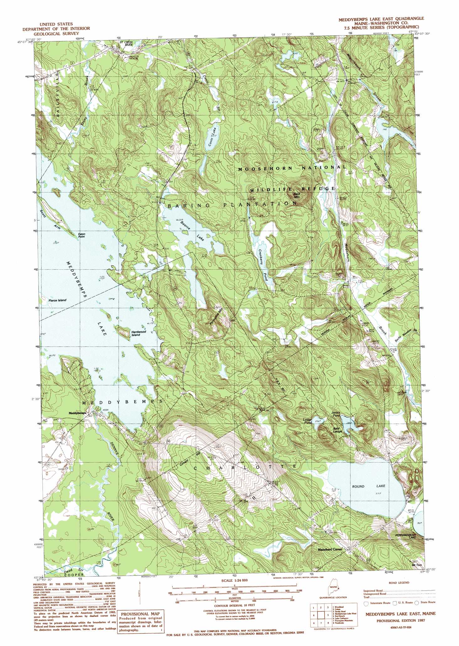
Meddybemp Lake East Topo Map Maine
To zoom in, hover over the map of Meddybemp Lake East
USGS Topo Quad 45067a3 - 1:24,000 scale
| Topo Map Name: | Meddybemp Lake East |
| USGS Topo Quad ID: | 45067a3 |
| Print Size: | ca. 21 1/4" wide x 27" high |
| Southeast Coordinates: | 45° N latitude / 67.25° W longitude |
| Map Center Coordinates: | 45.0625° N latitude / 67.3125° W longitude |
| U.S. State: | ME |
| Filename: | o45067a3.jpg |
| Download Map JPG Image: | Meddybemp Lake East topo map 1:24,000 scale |
| Map Type: | Topographic |
| Topo Series: | 7.5´ |
| Map Scale: | 1:24,000 |
| Source of Map Images: | United States Geological Survey (USGS) |
| Alternate Map Versions: |
Meddybemps Lake East ME 1987, updated 1988 Download PDF Buy paper map Meddybemps Lake East ME 2011 Download PDF Buy paper map Meddybemps Lake East ME 2014 Download PDF Buy paper map |
1:24,000 Topo Quads surrounding Meddybemp Lake East
Toman Ridge |
Kellyland |
|||
Princeton |
Woodland |
Calais |
Devils Head |
|
Crawford Lake |
Meddybemp Lake West |
Meddybemp Lake East |
Red Beach |
Robbinston |
Round Lake |
Lake Cathance |
Porcupine Mountain |
Pembroke |
Eastport |
Bog Lake |
Hadley Lake |
Long Lake |
Whiting |
West Lubec |
> Back to 45067a1 at 1:100,000 scale
> Back to 45066a1 at 1:250,000 scale
> Back to U.S. Topo Maps home
Meddybemp Lake East topo map: Gazetteer
Meddybemp Lake East: Airports
Flying Ed Airport elevation 121m 396′Gillespie Field elevation 58m 190′
Meddybemp Lake East: Capes
Eaton Point elevation 53m 173′Scott Arm elevation 58m 190′
Meddybemp Lake East: Dams
Bearce Flowage Dam elevation 59m 193′Conic Flowage Dam elevation 56m 183′
Cranberry Inlet Dam elevation 58m 190′
Cranberry Lake Dam elevation 55m 180′
Howard Mill Flowage Dam elevation 42m 137′
MacCrae Flowage Dam elevation 41m 134′
Meddybemps Lake Canal Dam elevation 52m 170′
Meddybemps Lake Dam elevation 56m 183′
Meddybemps Lake Dam and Fishway elevation 58m 190′
Snare Meadow Dam elevation 55m 180′
Tyler Flowage Dam elevation 37m 121′
Upper Goodall Heath Dam elevation 46m 150′
Meddybemp Lake East: Islands
Hardwood Island elevation 66m 216′Pierce Island elevation 53m 173′
Meddybemp Lake East: Lakes
Bearce Lake elevation 64m 209′Conic Lake elevation 61m 200′
James Pond elevation 56m 183′
Ledge Pond elevation 78m 255′
Round Lake elevation 23m 75′
Meddybemp Lake East: Parks
Moosehorn National Wildlife Refuge elevation 50m 164′Meddybemp Lake East: Populated Places
Blanchard Corner elevation 58m 190′Meddybemps elevation 54m 177′
Meddybemp Lake East: Reservoirs
Bearce Flowage elevation 59m 193′Conic Flowage elevation 46m 150′
Cranberry Inlet elevation 58m 190′
Cranberry Pond elevation 55m 180′
Howard Mill Flowage elevation 42m 137′
MacCrae Flowage elevation 41m 134′
Meddybemps Lake elevation 52m 170′
Snare Meadow elevation 55m 180′
Tyler Flowage elevation 37m 121′
Upper Pond elevation 46m 150′
Meddybemp Lake East: Streams
Dead Stream elevation 48m 157′Rocky Meadow Brook elevation 35m 114′
Meddybemp Lake East: Summits
Bald Ledge elevation 101m 331′Bald Mountain elevation 114m 374′
Conant Hill elevation 141m 462′
Mount Tom elevation 121m 396′
Porcupine Mountain elevation 71m 232′
Meddybemp Lake East digital topo map on disk
Buy this Meddybemp Lake East topo map showing relief, roads, GPS coordinates and other geographical features, as a high-resolution digital map file on DVD:
Maine, New Hampshire, Rhode Island & Eastern Massachusetts
Buy digital topo maps: Maine, New Hampshire, Rhode Island & Eastern Massachusetts