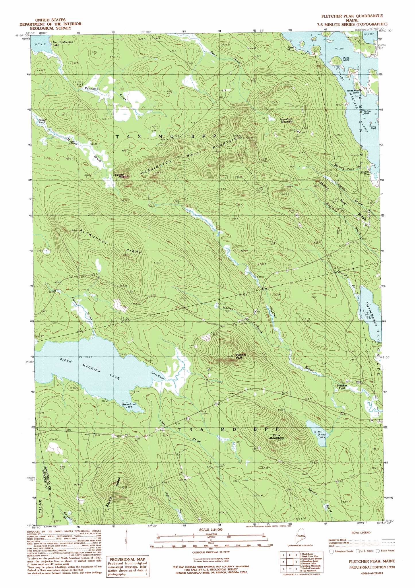
Fletcher Peak Topo Map Maine
To zoom in, hover over the map of Fletcher Peak
USGS Topo Quad 45067a8 - 1:24,000 scale
| Topo Map Name: | Fletcher Peak |
| USGS Topo Quad ID: | 45067a8 |
| Print Size: | ca. 21 1/4" wide x 27" high |
| Southeast Coordinates: | 45° N latitude / 67.875° W longitude |
| Map Center Coordinates: | 45.0625° N latitude / 67.9375° W longitude |
| U.S. State: | ME |
| Filename: | o45067a8.jpg |
| Download Map JPG Image: | Fletcher Peak topo map 1:24,000 scale |
| Map Type: | Topographic |
| Topo Series: | 7.5´ |
| Map Scale: | 1:24,000 |
| Source of Map Images: | United States Geological Survey (USGS) |
| Alternate Map Versions: |
Wabassus Lake SW ME 1975, updated 1980 Download PDF Buy paper map Fletcher Peak ME 1990, updated 1990 Download PDF Buy paper map Fletcher Peak ME 2011 Download PDF Buy paper map Fletcher Peak ME 2014 Download PDF Buy paper map |
1:24,000 Topo Quads surrounding Fletcher Peak
Weir Pond |
Bottle Lake |
Scraggly Lake |
Oxbrook Lakes |
Waite |
Spring Lake |
Duck Lake |
Dark Cove Mountain |
Grand Lake Stream |
Big Lake |
West Lake |
Gassabias Lake |
Fletcher Peak |
Monroe Lake |
Clifford Lake |
Alligator Lake |
Quillpig Mountain |
Peaked Mountain |
Tug Mountain |
Wesley |
Rocky Pond |
Lead Mountain |
Northeast Bluff |
Montegail Pond |
Peaked Mountain Pond |
> Back to 45067a1 at 1:100,000 scale
> Back to 45066a1 at 1:250,000 scale
> Back to U.S. Topo Maps home
Fletcher Peak topo map: Gazetteer
Fletcher Peak: Bays
Farm Cove elevation 92m 301′Greenland Cove elevation 114m 374′
Inlet Cove elevation 114m 374′
Mutton Cove elevation 96m 314′
Fletcher Peak: Islands
Big Ship Island elevation 91m 298′Little Ship Island elevation 91m 298′
Prune Island elevation 92m 301′
White Birch Island elevation 91m 298′
Fletcher Peak: Lakes
Beaver Pond elevation 109m 357′Fifth Machias Lake elevation 114m 374′
Knox Lake elevation 105m 344′
Second Machias Lake elevation 71m 232′
Fletcher Peak: Populated Places
Fletcher Field elevation 79m 259′Fletcher Peak: Ridges
Cherry Tree Ridge elevation 124m 406′Elwell Ridge elevation 175m 574′
Slewgundy Ridge elevation 246m 807′
Fletcher Peak: Streams
Dunning Brook elevation 75m 246′Elwell Brook elevation 115m 377′
Hadley Brook elevation 83m 272′
Hughes Brook elevation 111m 364′
Lake Brook elevation 114m 374′
Mutton Cove Brook elevation 102m 334′
Pennaman Brook elevation 96m 314′
Fletcher Peak: Summits
Farm Cove Mountain elevation 218m 715′Fletcher Peak elevation 238m 780′
Fletcher Peak elevation 135m 442′
Knox Mountain elevation 240m 787′
Washington Bald Mountain elevation 286m 938′
Fletcher Peak digital topo map on disk
Buy this Fletcher Peak topo map showing relief, roads, GPS coordinates and other geographical features, as a high-resolution digital map file on DVD:
Maine, New Hampshire, Rhode Island & Eastern Massachusetts
Buy digital topo maps: Maine, New Hampshire, Rhode Island & Eastern Massachusetts