Woodland Topo Map Maine
To zoom in, hover over the map of Woodland
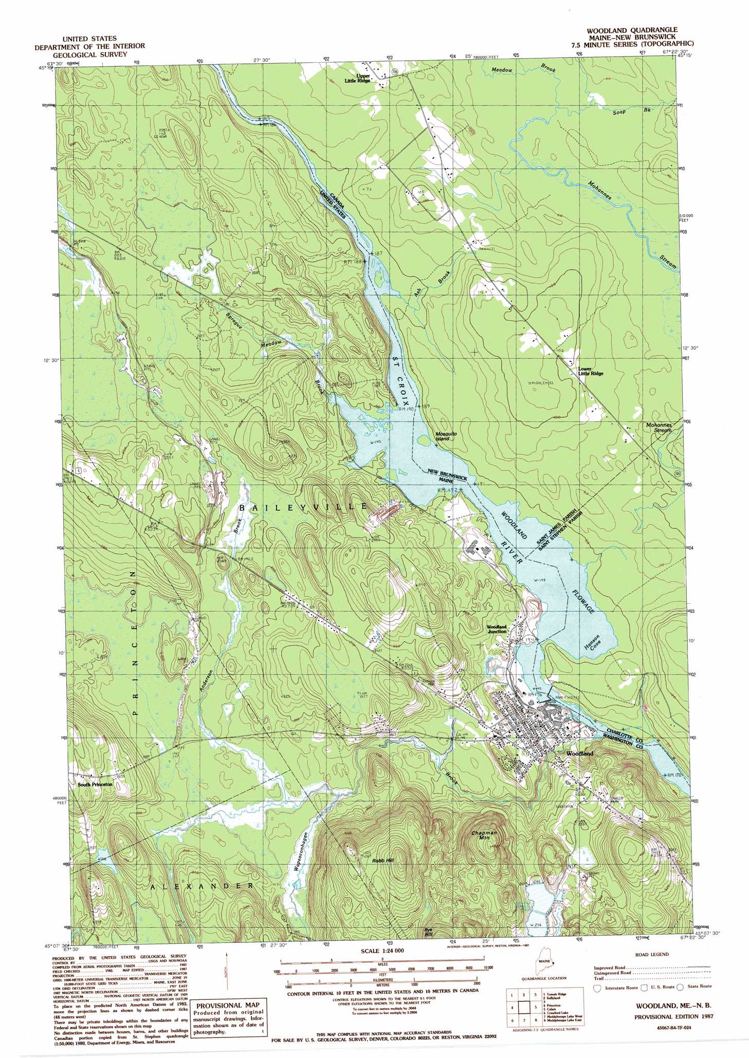
USGS Topo Quad 45067b4 - 1:24,000 scale
| Topo Map Name: | Woodland |
| USGS Topo Quad ID: | 45067b4 |
| Print Size: | ca. 21 1/4" wide x 27" high |
| Southeast Coordinates: | 45.125° N latitude / 67.375° W longitude |
| Map Center Coordinates: | 45.1875° N latitude / 67.4375° W longitude |
| U.S. State: | ME |
| Filename: | o45067b4.jpg |
| Download Map JPG Image: | Woodland topo map 1:24,000 scale |
| Map Type: | Topographic |
| Topo Series: | 7.5´ |
| Map Scale: | 1:24,000 |
| Source of Map Images: | United States Geological Survey (USGS) |
| Alternate Map Versions: |
Woodland ME 1987, updated 1987 Download PDF Buy paper map Woodland ME 2011 Download PDF Buy paper map Woodland ME 2014 Download PDF Buy paper map |
1:24,000 Topo Quads surrounding Woodland
Tomah Mountain |
Simsquish Lake |
Loon Bay |
||
Waite |
Toman Ridge |
Kellyland |
||
Big Lake |
Princeton |
Woodland |
Calais |
Devils Head |
Clifford Lake |
Crawford Lake |
Meddybemp Lake West |
Meddybemp Lake East |
Red Beach |
Wesley |
Round Lake |
Lake Cathance |
Porcupine Mountain |
Pembroke |
> Back to 45067a1 at 1:100,000 scale
> Back to 45066a1 at 1:250,000 scale
> Back to U.S. Topo Maps home
Woodland topo map: Gazetteer
Woodland: Airports
Georgia-Pacific Corporation Heliport elevation 46m 150′Woodland: Dams
Woodland Dam elevation 44m 144′Woodland: Populated Places
Woodland elevation 44m 144′Woodland Junction elevation 50m 164′
Woodland: Reservoirs
Saint Croix River Reservoir elevation 29m 95′Woodland Flowage elevation 44m 144′
Woodland: Streams
Anderson Brook elevation 52m 170′Sprague Meadow Brook elevation 44m 144′
Wapsaconhagan Brook elevation 26m 85′
Woodland: Summits
Chapman Mountain elevation 149m 488′Robb Hill elevation 146m 479′
Woodland digital topo map on disk
Buy this Woodland topo map showing relief, roads, GPS coordinates and other geographical features, as a high-resolution digital map file on DVD:
Maine, New Hampshire, Rhode Island & Eastern Massachusetts
Buy digital topo maps: Maine, New Hampshire, Rhode Island & Eastern Massachusetts