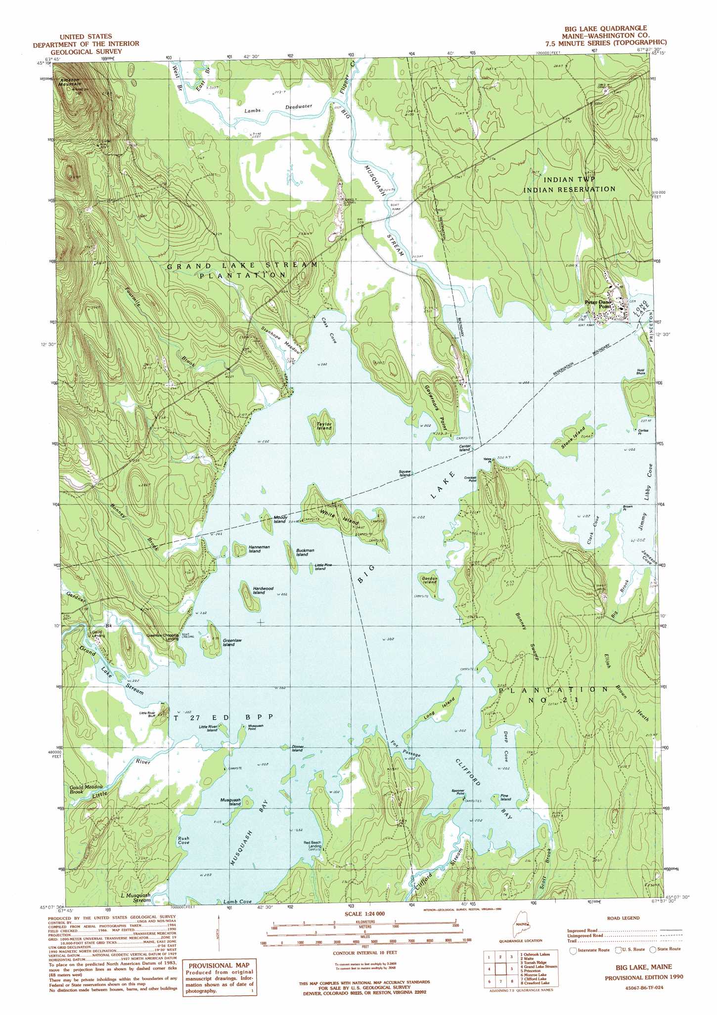
Big Lake Topo Map Maine
To zoom in, hover over the map of Big Lake
USGS Topo Quad 45067b6 - 1:24,000 scale
| Topo Map Name: | Big Lake |
| USGS Topo Quad ID: | 45067b6 |
| Print Size: | ca. 21 1/4" wide x 27" high |
| Southeast Coordinates: | 45.125° N latitude / 67.625° W longitude |
| Map Center Coordinates: | 45.1875° N latitude / 67.6875° W longitude |
| U.S. State: | ME |
| Filename: | o45067b6.jpg |
| Download Map JPG Image: | Big Lake topo map 1:24,000 scale |
| Map Type: | Topographic |
| Topo Series: | 7.5´ |
| Map Scale: | 1:24,000 |
| Source of Map Images: | United States Geological Survey (USGS) |
| Alternate Map Versions: |
Big Lake ME 1990, updated 1990 Download PDF Buy paper map Big Lake ME 2011 Download PDF Buy paper map Big Lake ME 2014 Download PDF Buy paper map |
1:24,000 Topo Quads surrounding Big Lake
Dill Hill |
Farrow Mountain |
Tomah Mountain |
Simsquish Lake |
Loon Bay |
Scraggly Lake |
Oxbrook Lakes |
Waite |
Toman Ridge |
Kellyland |
Dark Cove Mountain |
Grand Lake Stream |
Big Lake |
Princeton |
Woodland |
Fletcher Peak |
Monroe Lake |
Clifford Lake |
Crawford Lake |
Meddybemp Lake West |
Peaked Mountain |
Tug Mountain |
Wesley |
Round Lake |
Lake Cathance |
> Back to 45067a1 at 1:100,000 scale
> Back to 45066a1 at 1:250,000 scale
> Back to U.S. Topo Maps home
Big Lake topo map: Gazetteer
Big Lake: Bays
Cass Cove elevation 61m 200′Clark Cove elevation 61m 200′
Clifford Bay elevation 61m 200′
Deep Cove elevation 61m 200′
Jimmy Libby Cove elevation 61m 200′
Lamb Cove elevation 61m 200′
Musquash Bay elevation 61m 200′
Rush Cove elevation 62m 203′
Big Lake: Beaches
Campbell Shore elevation 63m 206′Big Lake: Capes
Brown Point elevation 61m 200′Corliss Point elevation 61m 200′
Crockett Point elevation 69m 226′
Governors Point elevation 67m 219′
Musquash Point elevation 62m 203′
Spooner Point elevation 62m 203′
Yates Point elevation 61m 200′
Big Lake: Channels
Fox Passage elevation 61m 200′Big Lake: Cliffs
Little River Bluff elevation 72m 236′Big Lake: Guts
Lambs Deadwater elevation 62m 203′Big Lake: Islands
Buckman Island elevation 64m 209′Center Island elevation 61m 200′
Dinner Island elevation 62m 203′
Epahsakom Island elevation 61m 200′
Gordon Island elevation 67m 219′
Greenlaw Island elevation 68m 223′
Hanneman Island elevation 66m 216′
Hardwood Island elevation 68m 223′
Little Pine Island elevation 61m 200′
Little River Island elevation 62m 203′
Long Island elevation 64m 209′
Moody Island elevation 64m 209′
Musquash Island elevation 62m 203′
Pine Island elevation 62m 203′
Stone Island elevation 64m 209′
Taylor Island elevation 68m 223′
White Island elevation 70m 229′
Big Lake: Lakes
Big Lake elevation 61m 200′Big Lake: Populated Places
Gould Landing elevation 64m 209′Greenlaw Chopping Landing elevation 63m 206′
Peter Dana Point elevation 67m 219′
Red Beach Landing elevation 62m 203′
Big Lake: Streams
Big Brook elevation 61m 200′Big Musquash Stream elevation 61m 200′
Bonney Brook elevation 61m 200′
Clifford Stream elevation 61m 200′
East Branch Big Musquash Stream elevation 63m 206′
Flipper Creek elevation 63m 206′
Fourmile Brook elevation 61m 200′
Gardner Brook elevation 64m 209′
Gould Meadow Brook elevation 64m 209′
Grand Lake Stream elevation 61m 200′
Little Musquash Stream elevation 61m 200′
Little River elevation 61m 200′
Scott Brook elevation 61m 200′
West Branch Big Musquash Stream elevation 63m 206′
Big Lake: Summits
Amazon Mountain elevation 238m 780′Big Lake: Swamps
Bonney Swamp elevation 63m 206′Elijah Brown Heath elevation 63m 206′
Stanhope Meadow elevation 62m 203′
Big Lake digital topo map on disk
Buy this Big Lake topo map showing relief, roads, GPS coordinates and other geographical features, as a high-resolution digital map file on DVD:
Maine, New Hampshire, Rhode Island & Eastern Massachusetts
Buy digital topo maps: Maine, New Hampshire, Rhode Island & Eastern Massachusetts