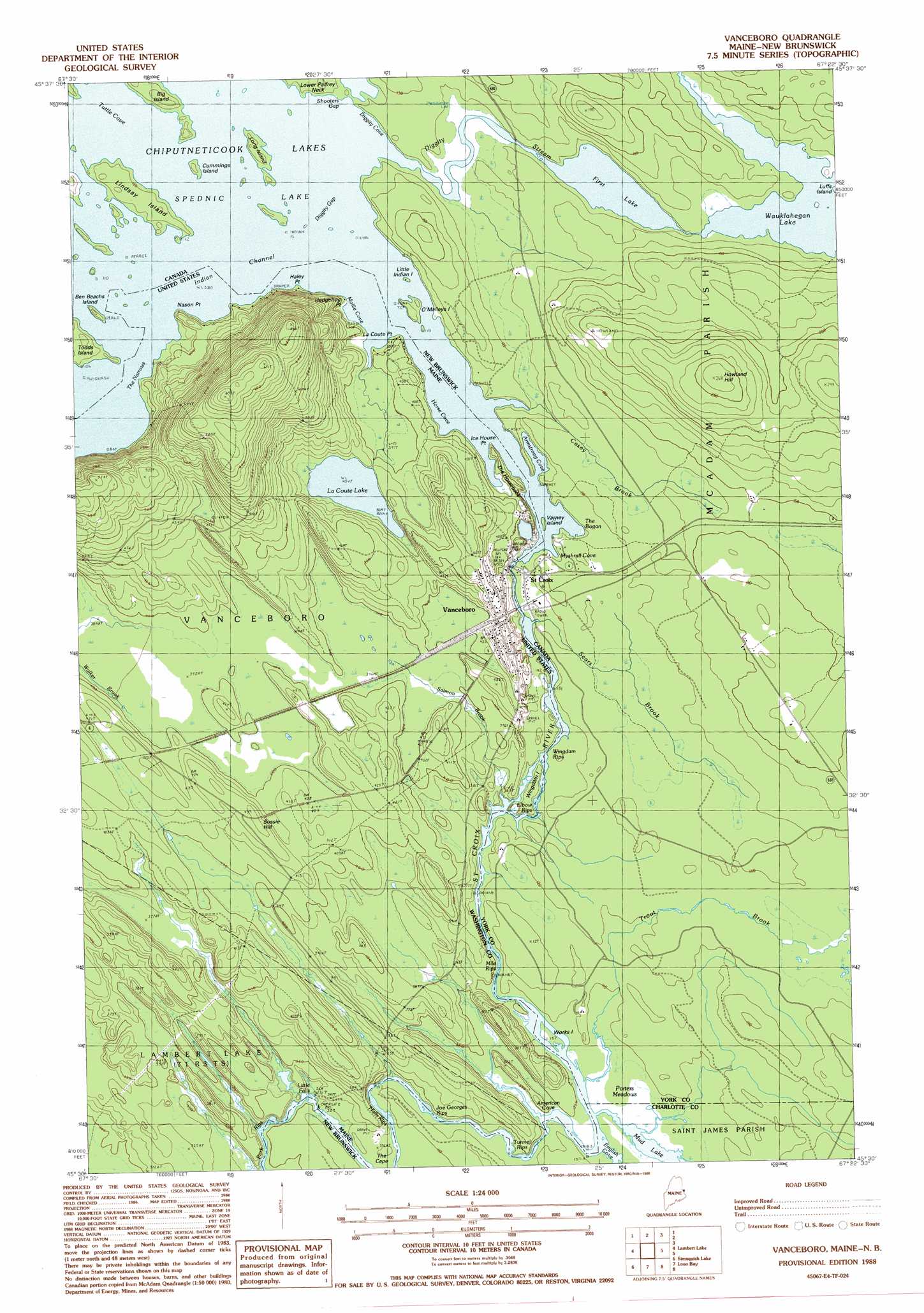
Vanceboro Topo Map Maine
To zoom in, hover over the map of Vanceboro
USGS Topo Quad 45067e4 - 1:24,000 scale
| Topo Map Name: | Vanceboro |
| USGS Topo Quad ID: | 45067e4 |
| Print Size: | ca. 21 1/4" wide x 27" high |
| Southeast Coordinates: | 45.5° N latitude / 67.375° W longitude |
| Map Center Coordinates: | 45.5625° N latitude / 67.4375° W longitude |
| U.S. State: | ME |
| Filename: | o45067e4.jpg |
| Download Map JPG Image: | Vanceboro topo map 1:24,000 scale |
| Map Type: | Topographic |
| Topo Series: | 7.5´ |
| Map Scale: | 1:24,000 |
| Source of Map Images: | United States Geological Survey (USGS) |
| Alternate Map Versions: |
Vanceboro ME 1988, updated 1988 Download PDF Buy paper map Vanceboro ME 2011 Download PDF Buy paper map Vanceboro ME 2014 Download PDF Buy paper map |
1:24,000 Topo Quads surrounding Vanceboro
Forest City |
||||
Forest |
Lambert Lake |
Vanceboro |
||
Tomah Mountain |
Simsquish Lake |
Loon Bay |
||
Waite |
Toman Ridge |
Kellyland |
> Back to 45067e1 at 1:100,000 scale
> Back to 45066a1 at 1:250,000 scale
> Back to U.S. Topo Maps home
Vanceboro topo map: Gazetteer
Vanceboro: Airports
Vanceboro Heliport elevation 116m 380′Vanceboro: Bays
American Cove elevation 103m 337′Horse Cove elevation 116m 380′
Mollie Cove elevation 116m 380′
Vanceboro: Capes
Haley Point elevation 116m 380′Hedgehog Point elevation 116m 380′
Ice House Point elevation 121m 396′
LaCoute Point elevation 117m 383′
Nason Point elevation 117m 383′
The Cape elevation 104m 341′
Vanceboro: Channels
Indian Channel elevation 116m 380′The Narrows Channel elevation 116m 380′
Vanceboro: Dams
Vanceboro Dam elevation 116m 380′Vanceboro: Falls
Little Falls elevation 96m 314′Vanceboro: Islands
Billy Semple Island elevation 116m 380′Wingdam Island elevation 114m 374′
Vanceboro: Lakes
LaCoute Lake elevation 123m 403′Vanceboro: Populated Places
Vanceboro elevation 124m 406′Vanceboro: Post Offices
Vanceboro Post Office (historical) elevation 130m 426′Vanceboro: Rapids
Elbow Rips elevation 115m 377′Halls Rips elevation 101m 331′
Joe Georges Rips elevation 102m 334′
Mile Rips elevation 107m 351′
Pork Rips elevation 98m 321′
Tunnel Rips elevation 103m 337′
Wingdam Rips elevation 112m 367′
Vanceboro: Reservoirs
Spednic Lake elevation 116m 380′Spednik Lake elevation 116m 380′
Vanceboro: Ridges
The Horseback elevation 121m 396′Vanceboro: Streams
Salmon Brook elevation 108m 354′Vanceboro: Summits
Sussie Hill elevation 134m 439′Vanceboro digital topo map on disk
Buy this Vanceboro topo map showing relief, roads, GPS coordinates and other geographical features, as a high-resolution digital map file on DVD:
Maine, New Hampshire, Rhode Island & Eastern Massachusetts
Buy digital topo maps: Maine, New Hampshire, Rhode Island & Eastern Massachusetts