Stetson Mountain Topo Map Maine
To zoom in, hover over the map of Stetson Mountain
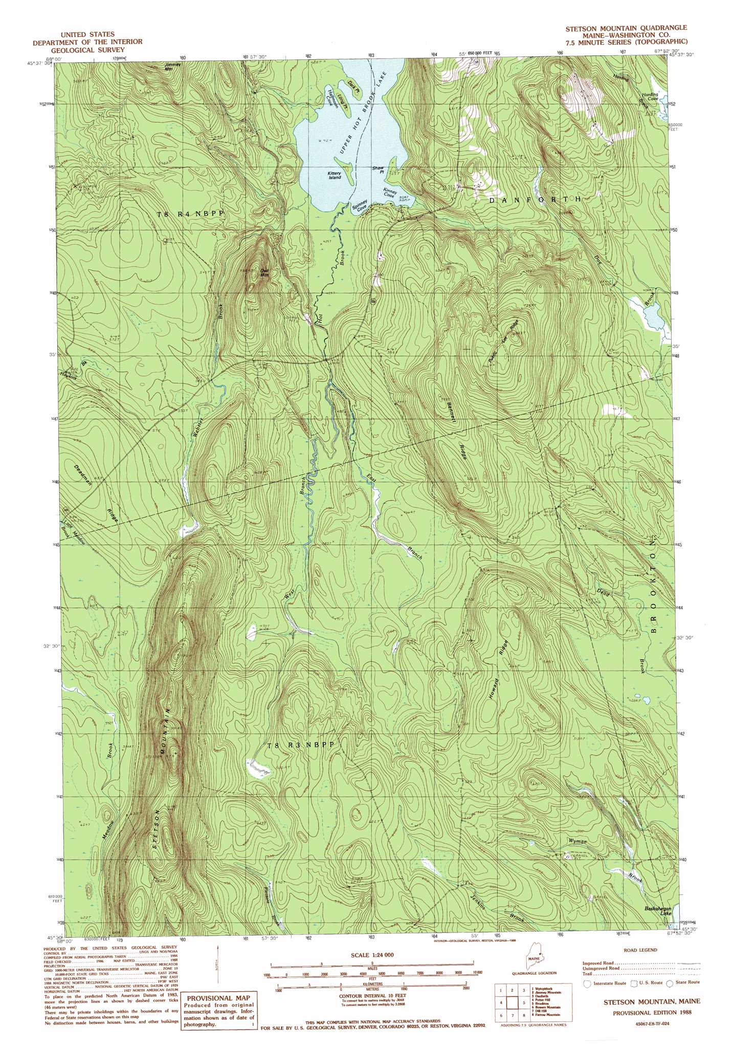
USGS Topo Quad 45067e8 - 1:24,000 scale
| Topo Map Name: | Stetson Mountain |
| USGS Topo Quad ID: | 45067e8 |
| Print Size: | ca. 21 1/4" wide x 27" high |
| Southeast Coordinates: | 45.5° N latitude / 67.875° W longitude |
| Map Center Coordinates: | 45.5625° N latitude / 67.9375° W longitude |
| U.S. State: | ME |
| Filename: | o45067e8.jpg |
| Download Map JPG Image: | Stetson Mountain topo map 1:24,000 scale |
| Map Type: | Topographic |
| Topo Series: | 7.5´ |
| Map Scale: | 1:24,000 |
| Source of Map Images: | United States Geological Survey (USGS) |
| Alternate Map Versions: |
Danforth SW ME 1975, updated 1980 Download PDF Buy paper map Stetson Mountain ME 1988, updated 1988 Download PDF Buy paper map Stetson Mountain ME 2011 Download PDF Buy paper map Stetson Mountain ME 2014 Download PDF Buy paper map |
1:24,000 Topo Quads surrounding Stetson Mountain
Wytopitlock Lake |
Alder Brook |
Haynesville |
Orient |
|
Reed Pond |
Wytopitlock |
Jimmey Mountain |
Danforth |
Forest City |
Kingman |
Potter Hill |
Stetson Mountain |
Brookton |
Forest |
Springfield |
Bowers Mountain |
Dill Hill |
Farrow Mountain |
Tomah Mountain |
Weir Pond |
Bottle Lake |
Scraggly Lake |
Oxbrook Lakes |
Waite |
> Back to 45067e1 at 1:100,000 scale
> Back to 45066a1 at 1:250,000 scale
> Back to U.S. Topo Maps home
Stetson Mountain topo map: Gazetteer
Stetson Mountain: Bays
Halfmoon Cove elevation 129m 423′Kinney Cove elevation 129m 423′
Spinney Cove elevation 129m 423′
Stetson Mountain: Capes
Dark Point elevation 129m 423′Long Point elevation 129m 423′
Shaw Point elevation 130m 426′
Stetson Mountain: Islands
Kittery Island elevation 129m 423′Stetson Mountain: Lakes
Upper Hot Brook Lake elevation 129m 423′Stetson Mountain: Ridges
Bennett Ridge elevation 211m 692′Deadman Ridge elevation 206m 675′
Howard Ridge elevation 200m 656′
Public Lot Ridge elevation 262m 859′
Stetson Mountain: Streams
East Branch Hot Brook elevation 137m 449′Harding Brook elevation 118m 387′
Webster Brook elevation 130m 426′
West Branch Hot Brook elevation 136m 446′
Wyman Brook elevation 132m 433′
Stetson Mountain: Summits
Owl Mountain elevation 224m 734′Stetson Mountain elevation 326m 1069′
Stetson Mountain digital topo map on disk
Buy this Stetson Mountain topo map showing relief, roads, GPS coordinates and other geographical features, as a high-resolution digital map file on DVD:
Maine, New Hampshire, Rhode Island & Eastern Massachusetts
Buy digital topo maps: Maine, New Hampshire, Rhode Island & Eastern Massachusetts