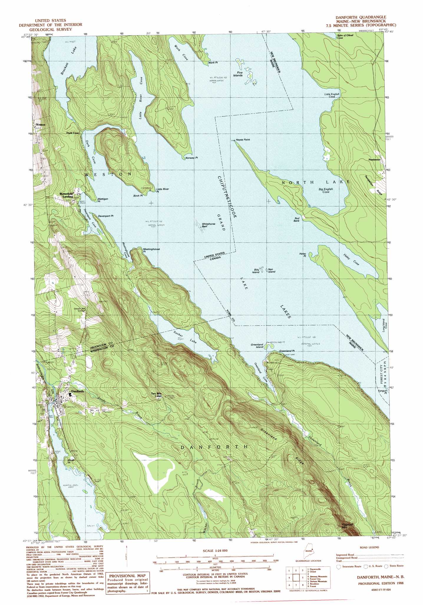
Danforth Topo Map Maine
To zoom in, hover over the map of Danforth
USGS Topo Quad 45067f7 - 1:24,000 scale
| Topo Map Name: | Danforth |
| USGS Topo Quad ID: | 45067f7 |
| Print Size: | ca. 21 1/4" wide x 27" high |
| Southeast Coordinates: | 45.625° N latitude / 67.75° W longitude |
| Map Center Coordinates: | 45.6875° N latitude / 67.8125° W longitude |
| U.S. State: | ME |
| Filename: | o45067f7.jpg |
| Download Map JPG Image: | Danforth topo map 1:24,000 scale |
| Map Type: | Topographic |
| Topo Series: | 7.5´ |
| Map Scale: | 1:24,000 |
| Source of Map Images: | United States Geological Survey (USGS) |
| Alternate Map Versions: |
Danforth NE ME 1975, updated 1980 Download PDF Buy paper map Danforth ME 1988, updated 1988 Download PDF Buy paper map Danforth ME 2011 Download PDF Buy paper map Danforth ME 2014 Download PDF Buy paper map |
1:24,000 Topo Quads surrounding Danforth
Monument Brook |
Ten Mile Lake |
North Amity |
||
Alder Brook |
Haynesville |
Orient |
||
Wytopitlock |
Jimmey Mountain |
Danforth |
Forest City |
|
Potter Hill |
Stetson Mountain |
Brookton |
Forest |
Lambert Lake |
Bowers Mountain |
Dill Hill |
Farrow Mountain |
Tomah Mountain |
Simsquish Lake |
> Back to 45067e1 at 1:100,000 scale
> Back to 45066a1 at 1:250,000 scale
> Back to U.S. Topo Maps home
Danforth topo map: Gazetteer
Danforth: Bars
Whitehorse Reef elevation 132m 433′Danforth: Bays
Dark Cove elevation 132m 433′Davenport Cove elevation 133m 436′
Greenland Cove elevation 132m 433′
Little River Cove elevation 132m 433′
Meetinghouse Cove elevation 133m 436′
Work Cove elevation 132m 433′
Danforth: Capes
Birch Point elevation 132m 433′Birch Point elevation 117m 383′
Davenport Point elevation 132m 433′
Greenland Point elevation 137m 449′
Little River Point elevation 138m 452′
Mattigan Point elevation 132m 433′
Meetinghouse Point elevation 132m 433′
Norway Point elevation 134m 439′
Work Point elevation 132m 433′
Danforth: Dams
Crooked Brook Dam elevation 116m 380′Danforth: Islands
Five Islands elevation 132m 433′Greenland Island elevation 132m 433′
Danforth: Lakes
Brackett Lake elevation 136m 446′Grand Lake elevation 132m 433′
Sucker Lake elevation 141m 462′
Danforth: Populated Places
Butterfield Landing elevation 134m 439′Danforth elevation 116m 380′
Danforth: Post Offices
Danforth Post Office elevation 116m 380′Danforth: Reservoirs
Crooked Brook Flowage elevation 116m 380′Danforth: Ridges
Greenland Ridge elevation 249m 816′Danforth: Streams
Greenland Brook elevation 132m 433′Sandy Brook elevation 115m 377′
Danforth: Summits
Flagstaff Mountain elevation 303m 994′Danforth digital topo map on disk
Buy this Danforth topo map showing relief, roads, GPS coordinates and other geographical features, as a high-resolution digital map file on DVD:
Maine, New Hampshire, Rhode Island & Eastern Massachusetts
Buy digital topo maps: Maine, New Hampshire, Rhode Island & Eastern Massachusetts