Ten Mile Lake Topo Map Maine
To zoom in, hover over the map of Ten Mile Lake
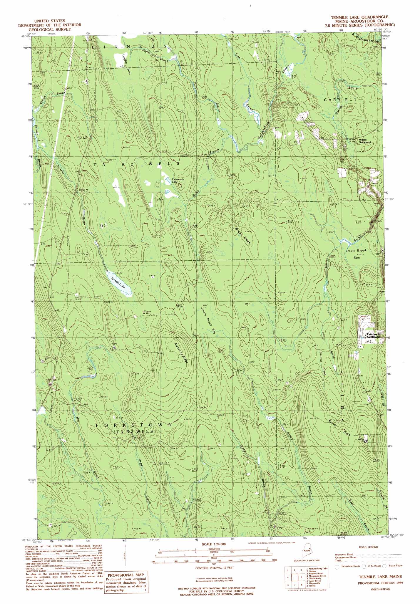
USGS Topo Quad 45067h8 - 1:24,000 scale
| Topo Map Name: | Ten Mile Lake |
| USGS Topo Quad ID: | 45067h8 |
| Print Size: | ca. 21 1/4" wide x 27" high |
| Southeast Coordinates: | 45.875° N latitude / 67.875° W longitude |
| Map Center Coordinates: | 45.9375° N latitude / 67.9375° W longitude |
| U.S. State: | ME |
| Filename: | o45067h8.jpg |
| Download Map JPG Image: | Ten Mile Lake topo map 1:24,000 scale |
| Map Type: | Topographic |
| Topo Series: | 7.5´ |
| Map Scale: | 1:24,000 |
| Source of Map Images: | United States Geological Survey (USGS) |
| Alternate Map Versions: |
Amity NW ME 1975, updated 1980 Download PDF Buy paper map Tenmile Lake ME 1989, updated 1989 Download PDF Buy paper map Ten Mile Lake ME 2011 Download PDF Buy paper map Ten Mile Lake ME 2014 Download PDF Buy paper map |
1:24,000 Topo Quads surrounding Ten Mile Lake
Smyrna Mills |
Ludlow |
Twin Brook |
Houlton North |
|
Oakfield |
Meduxnekeag Lake |
Linneus |
Houlton South |
|
Mattawamkeag Lake |
Monument Brook |
Ten Mile Lake |
North Amity |
|
Wytopitlock Lake |
Alder Brook |
Haynesville |
Orient |
|
Reed Pond |
Wytopitlock |
Jimmey Mountain |
Danforth |
Forest City |
> Back to 45067e1 at 1:100,000 scale
> Back to 45066a1 at 1:250,000 scale
> Back to U.S. Topo Maps home
Ten Mile Lake topo map: Gazetteer
Ten Mile Lake: Lakes
Tenmile Lake elevation 183m 600′Ten Mile Lake: Populated Places
Estabrook Settlement elevation 207m 679′Ten Mile Lake: Reservoirs
Elevenmile Lake elevation 175m 574′Ten Mile Lake: Ridges
Burnt Dam Ridge elevation 211m 692′Stetson Ridge elevation 209m 685′
Sugar Ridge elevation 192m 629′
Ten Mile Lake: Streams
Coffin Brook elevation 165m 541′First Brook elevation 166m 544′
Foss Brook elevation 154m 505′
Haney Brook elevation 135m 442′
North Branch Meduxnekeag Stream elevation 157m 515′
Second Brook elevation 173m 567′
South Branch Meduxnekeag Stream elevation 157m 515′
Stony Brook elevation 152m 498′
Tenmile Brook elevation 171m 561′
Yellow Brook elevation 172m 564′
Ten Mile Lake: Swamps
Coffin Bog elevation 172m 564′Davis Brook Bog elevation 161m 528′
Jimmy Brook Bog elevation 178m 583′
Ten Mile Lake digital topo map on disk
Buy this Ten Mile Lake topo map showing relief, roads, GPS coordinates and other geographical features, as a high-resolution digital map file on DVD:
Maine, New Hampshire, Rhode Island & Eastern Massachusetts
Buy digital topo maps: Maine, New Hampshire, Rhode Island & Eastern Massachusetts