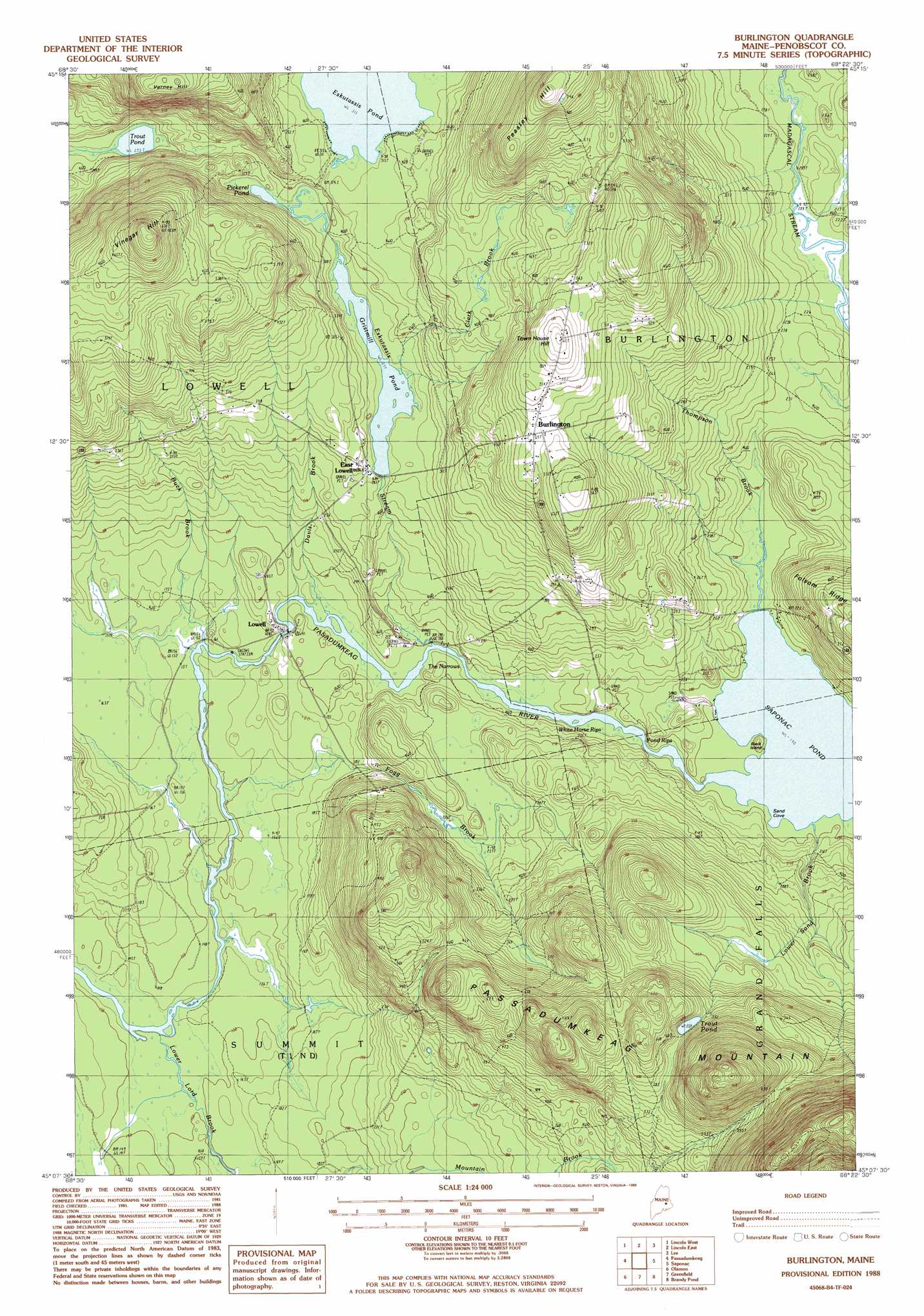
Burlington Topo Map Maine
To zoom in, hover over the map of Burlington
USGS Topo Quad 45068b4 - 1:24,000 scale
| Topo Map Name: | Burlington |
| USGS Topo Quad ID: | 45068b4 |
| Print Size: | ca. 21 1/4" wide x 27" high |
| Southeast Coordinates: | 45.125° N latitude / 68.375° W longitude |
| Map Center Coordinates: | 45.1875° N latitude / 68.4375° W longitude |
| U.S. State: | ME |
| Filename: | o45068b4.jpg |
| Download Map JPG Image: | Burlington topo map 1:24,000 scale |
| Map Type: | Topographic |
| Topo Series: | 7.5´ |
| Map Scale: | 1:24,000 |
| Source of Map Images: | United States Geological Survey (USGS) |
| Alternate Map Versions: |
Saponac NW ME 1975, updated 1980 Download PDF Buy paper map Burlington ME 1988, updated 1988 Download PDF Buy paper map Burlington ME 2011 Download PDF Buy paper map Burlington ME 2014 Download PDF Buy paper map |
1:24,000 Topo Quads surrounding Burlington
Mattamiscontis Mountain |
Nine Meadow Ridge |
Lincoln Center |
East Winn |
Springfield |
Seboeis |
Lincoln West |
Lincoln East |
Lee |
Weir Pond |
Howland |
Passadumkeag |
Burlington |
Saponac |
Spring Lake |
Greenbush |
Olamon |
Greenfield |
Brandy Pond |
West Lake |
Old Town |
Otter Chain Ponds |
The Horseback |
Great Pond |
Alligator Lake |
> Back to 45068a1 at 1:100,000 scale
> Back to 45068a1 at 1:250,000 scale
> Back to U.S. Topo Maps home
Burlington topo map: Gazetteer
Burlington: Bays
Sand Cove elevation 64m 209′Burlington: Channels
The Narrows elevation 58m 190′Burlington: Dams
Eskutassis Stream Dam elevation 84m 275′Burlington: Islands
Black Island elevation 59m 193′Burlington: Lakes
Pickerel Pond elevation 86m 282′Saponac Pond elevation 58m 190′
Trout Pond elevation 71m 232′
Trout Pond elevation 181m 593′
Burlington: Populated Places
Burlington elevation 156m 511′East Lowell elevation 90m 295′
Lowell elevation 61m 200′
Burlington: Rapids
Pond Rips elevation 59m 193′White Horse Rips elevation 56m 183′
Burlington: Reservoirs
Gristmill Pond elevation 84m 275′Burlington: Ridges
Folsom Ridge elevation 96m 314′Burlington: Streams
Buck Brook elevation 47m 154′Clark Brook elevation 84m 275′
Davis Brook elevation 56m 183′
Eskutassis Stream elevation 56m 183′
Fogg Brook elevation 43m 141′
Lower Lord Brook elevation 40m 131′
Lower Sand Brook elevation 58m 190′
Oaks Bog Brook elevation 65m 213′
Thompson Brook elevation 61m 200′
Burlington: Summits
Peasley Hill elevation 209m 685′Town House Hill elevation 187m 613′
Varney Hill elevation 210m 688′
Vinegar Hill elevation 239m 784′
Burlington digital topo map on disk
Buy this Burlington topo map showing relief, roads, GPS coordinates and other geographical features, as a high-resolution digital map file on DVD:
Maine, New Hampshire, Rhode Island & Eastern Massachusetts
Buy digital topo maps: Maine, New Hampshire, Rhode Island & Eastern Massachusetts