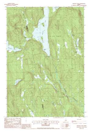
Endless Lake Topo Map Maine
To zoom in, hover over the map of Endless Lake
USGS Topo Quad 45068d7 - 1:24,000 scale
| Topo Map Name: | Endless Lake |
| USGS Topo Quad ID: | 45068d7 |
| Print Size: | ca. 21 1/4" wide x 27" high |
| Southeast Coordinates: | 45.375° N latitude / 68.75° W longitude |
| Map Center Coordinates: | 45.4375° N latitude / 68.8125° W longitude |
| U.S. State: | ME |
| Filename: | o45068d7.jpg |
| Download Map JPG Image: | Endless Lake topo map 1:24,000 scale |
| Map Type: | Topographic |
| Topo Series: | 7.5´ |
| Map Scale: | 1:24,000 |
| Source of Map Images: | United States Geological Survey (USGS) |
| Alternate Map Versions: |
Endless Lake ME 1978, updated 1981 Download PDF Buy paper map Endless Lake ME 1988, updated 1988 Download PDF Buy paper map Endless Lake ME 2011 Download PDF Buy paper map Endless Lake ME 2014 Download PDF Buy paper map |
1:24,000 Topo Quads surrounding Endless Lake
> Back to 45068a1 at 1:100,000 scale
> Back to 45068a1 at 1:250,000 scale
> Back to U.S. Topo Maps home
Endless Lake topo map: Gazetteer
Endless Lake: Bays
Deadman Cove elevation 125m 410′Endless Lake: Dams
Seboeis Dam elevation 134m 439′Endless Lake: Islands
Big Island elevation 131m 429′Blueberry Island elevation 130m 426′
Endless Lake: Lakes
Bog Pond elevation 115m 377′Lard Pond elevation 174m 570′
Lower Deadwater elevation 114m 374′
Turtle Pond elevation 173m 567′
Upper Deadwater elevation 128m 419′
Endless Lake: Rapids
Dudley Rips elevation 127m 416′Endless Lake: Reservoirs
Endless Lake elevation 125m 410′Endless Lake: Ridges
Miller Ridge elevation 133m 436′Endless Lake: Streams
Otter Brook elevation 127m 416′Roaring Brook elevation 92m 301′
Endless Lake: Swamps
Caribou Bog elevation 154m 505′Miller Bog elevation 144m 472′
One Thousand Acre Bog elevation 145m 475′
Endless Lake: Trails
Lake Trail elevation 144m 472′Lard Camp Trail elevation 202m 662′
Shore Trail elevation 95m 311′
Endless Lake digital topo map on disk
Buy this Endless Lake topo map showing relief, roads, GPS coordinates and other geographical features, as a high-resolution digital map file on DVD:
Maine, New Hampshire, Rhode Island & Eastern Massachusetts
Buy digital topo maps: Maine, New Hampshire, Rhode Island & Eastern Massachusetts


