Mattawamkeag Topo Map Maine
To zoom in, hover over the map of Mattawamkeag
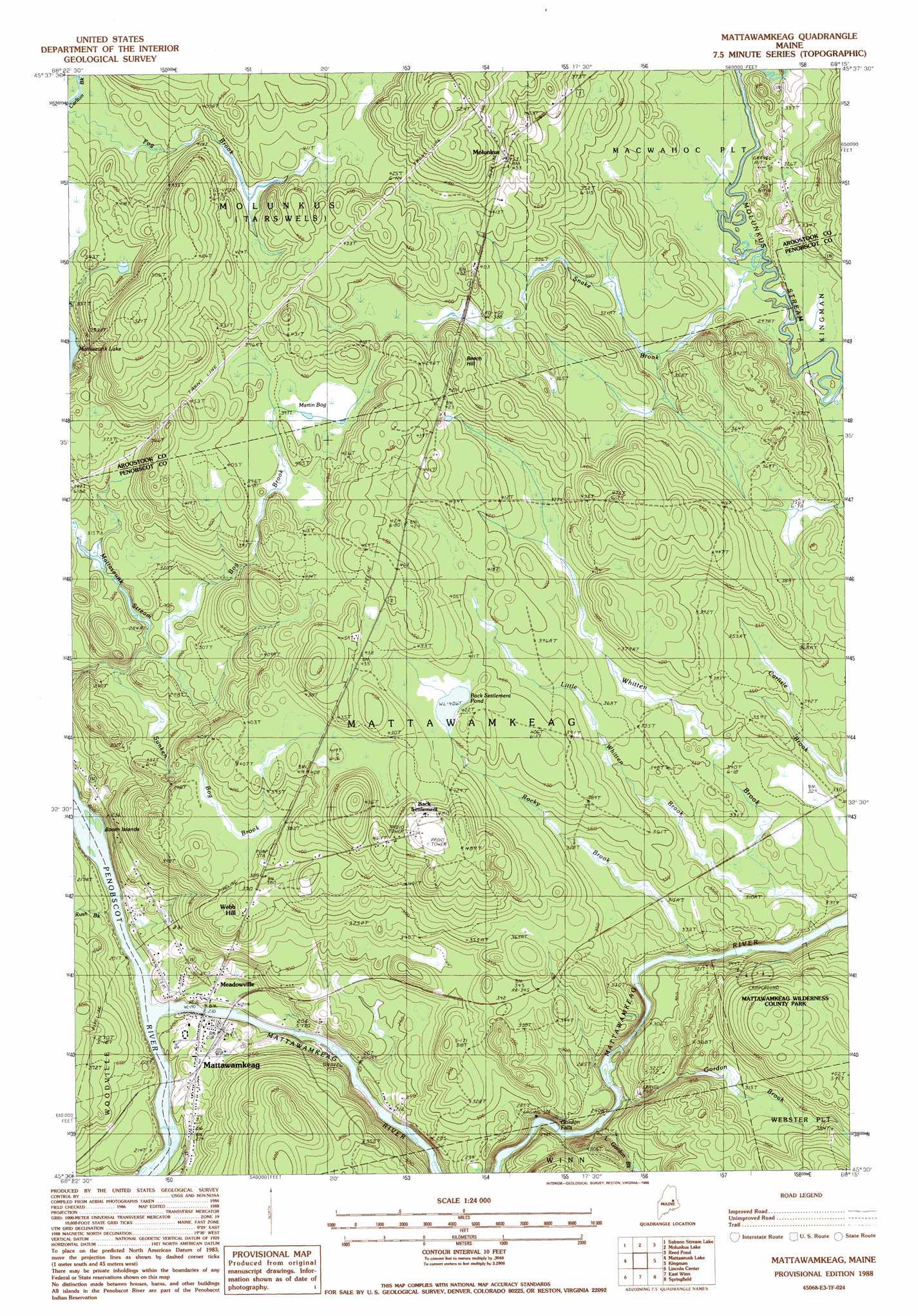
USGS Topo Quad 45068e3 - 1:24,000 scale
| Topo Map Name: | Mattawamkeag |
| USGS Topo Quad ID: | 45068e3 |
| Print Size: | ca. 21 1/4" wide x 27" high |
| Southeast Coordinates: | 45.5° N latitude / 68.25° W longitude |
| Map Center Coordinates: | 45.5625° N latitude / 68.3125° W longitude |
| U.S. State: | ME |
| Filename: | o45068e3.jpg |
| Download Map JPG Image: | Mattawamkeag topo map 1:24,000 scale |
| Map Type: | Topographic |
| Topo Series: | 7.5´ |
| Map Scale: | 1:24,000 |
| Source of Map Images: | United States Geological Survey (USGS) |
| Alternate Map Versions: |
Mattawamkeag ME 1988, updated 1988 Download PDF Buy paper map Mattawamkeag ME 2011 Download PDF Buy paper map Mattawamkeag ME 2014 Download PDF Buy paper map |
1:24,000 Topo Quads surrounding Mattawamkeag
Stacyville |
Benedicta |
Monarda |
Wytopitlock Lake |
Alder Brook |
East Millinocket |
Salmon Stream Lake |
Molunkid Lake |
Reed Pond |
Wytopitlock |
Medunkeunk Lake |
Mattaseunk Lake |
Mattawamkeag |
Kingman |
Potter Hill |
Nine Meadow Ridge |
Lincoln Center |
East Winn |
Springfield |
Bowers Mountain |
Lincoln West |
Lincoln East |
Lee |
Weir Pond |
Bottle Lake |
> Back to 45068e1 at 1:100,000 scale
> Back to 45068a1 at 1:250,000 scale
> Back to U.S. Topo Maps home
Mattawamkeag topo map: Gazetteer
Mattawamkeag: Falls
Gordon Falls elevation 64m 209′Mattawamkeag: Islands
Boom Islands elevation 57m 187′Mattawamkeag: Lakes
Back Settlement Pond elevation 124m 406′Mattawamkeag: Parks
Mattawamkeag Wilderness County Park elevation 140m 459′Mattawamkeag: Populated Places
Back Settlement elevation 151m 495′Gordon (historical) elevation 100m 328′
Mattawamkeag elevation 68m 223′
Meadowville elevation 62m 203′
Molunkus elevation 138m 452′
Webb Hill elevation 112m 367′
Mattawamkeag: Streams
Bog Brook elevation 86m 282′Fog Brook elevation 108m 354′
Gordon Brook elevation 76m 249′
Little Gordon Brook elevation 72m 236′
Little Whitten Brook elevation 93m 305′
Mattawamkeag River elevation 57m 187′
Meadow Brook elevation 60m 196′
Rush Brook elevation 58m 190′
Snake Brook elevation 91m 298′
Sunken Bog Brook elevation 82m 269′
Mattawamkeag: Summits
Beech Hill elevation 141m 462′Mattawamkeag: Swamps
Martin Bog elevation 120m 393′Mattawamkeag digital topo map on disk
Buy this Mattawamkeag topo map showing relief, roads, GPS coordinates and other geographical features, as a high-resolution digital map file on DVD:
Maine, New Hampshire, Rhode Island & Eastern Massachusetts
Buy digital topo maps: Maine, New Hampshire, Rhode Island & Eastern Massachusetts