Nollesemic Lake Topo Map Maine
To zoom in, hover over the map of Nollesemic Lake
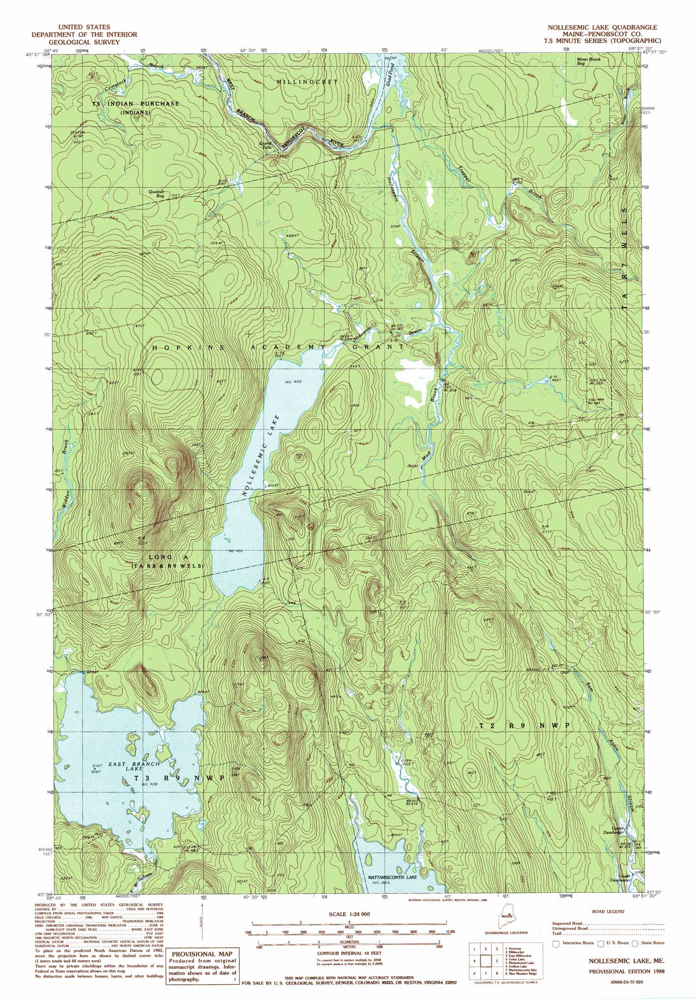
USGS Topo Quad 45068e6 - 1:24,000 scale
| Topo Map Name: | Nollesemic Lake |
| USGS Topo Quad ID: | 45068e6 |
| Print Size: | ca. 21 1/4" wide x 27" high |
| Southeast Coordinates: | 45.5° N latitude / 68.625° W longitude |
| Map Center Coordinates: | 45.5625° N latitude / 68.6875° W longitude |
| U.S. State: | ME |
| Filename: | o45068e6.jpg |
| Download Map JPG Image: | Nollesemic Lake topo map 1:24,000 scale |
| Map Type: | Topographic |
| Topo Series: | 7.5´ |
| Map Scale: | 1:24,000 |
| Source of Map Images: | United States Geological Survey (USGS) |
| Alternate Map Versions: |
Millinocket SW ME 1975, updated 1979 Download PDF Buy paper map Millinocket SW ME 1975, updated 1980 Download PDF Buy paper map Nollesemic Lake ME 1988, updated 1988 Download PDF Buy paper map Nollesemic Lake ME 2011 Download PDF Buy paper map Nollesemic Lake ME 2014 Download PDF Buy paper map |
1:24,000 Topo Quads surrounding Nollesemic Lake
Abol Pond |
Trout Mountain |
Whetstone Mountain |
Stacyville |
Benedicta |
Pemadumcook Lake |
Norcross |
Millinocket |
East Millinocket |
Salmon Stream Lake |
Ragged Mountain |
Cedar Lake |
Nollesemic Lake |
Medunkeunk Lake |
Mattaseunk Lake |
Seboeis Lake |
Endless Lake |
Mattamiscontis Mountain |
Nine Meadow Ridge |
Lincoln Center |
Milo North |
Hardy Pond |
Seboeis |
Lincoln West |
Lincoln East |
> Back to 45068e1 at 1:100,000 scale
> Back to 45068a1 at 1:250,000 scale
> Back to U.S. Topo Maps home
Nollesemic Lake topo map: Gazetteer
Nollesemic Lake: Falls
Grand Falls elevation 120m 393′Nollesemic Lake: Lakes
East Branch Lake elevation 132m 433′Lower Deadwater elevation 109m 357′
Nollesemic Lake elevation 122m 400′
Shad Pond elevation 103m 337′
Upper Deadwater elevation 111m 364′
Nollesemic Lake: Streams
Comstock Brook elevation 131m 429′Mud Brook elevation 108m 354′
Nollesemic Stream elevation 103m 337′
Trapper Brook elevation 104m 341′
Widden Brook elevation 130m 426′
Nollesemic Lake: Swamps
Miner Brook Bog elevation 119m 390′Quakish Bog elevation 156m 511′
Nollesemic Lake digital topo map on disk
Buy this Nollesemic Lake topo map showing relief, roads, GPS coordinates and other geographical features, as a high-resolution digital map file on DVD:
Maine, New Hampshire, Rhode Island & Eastern Massachusetts
Buy digital topo maps: Maine, New Hampshire, Rhode Island & Eastern Massachusetts