Whetstone Mountain Topo Map Maine
To zoom in, hover over the map of Whetstone Mountain
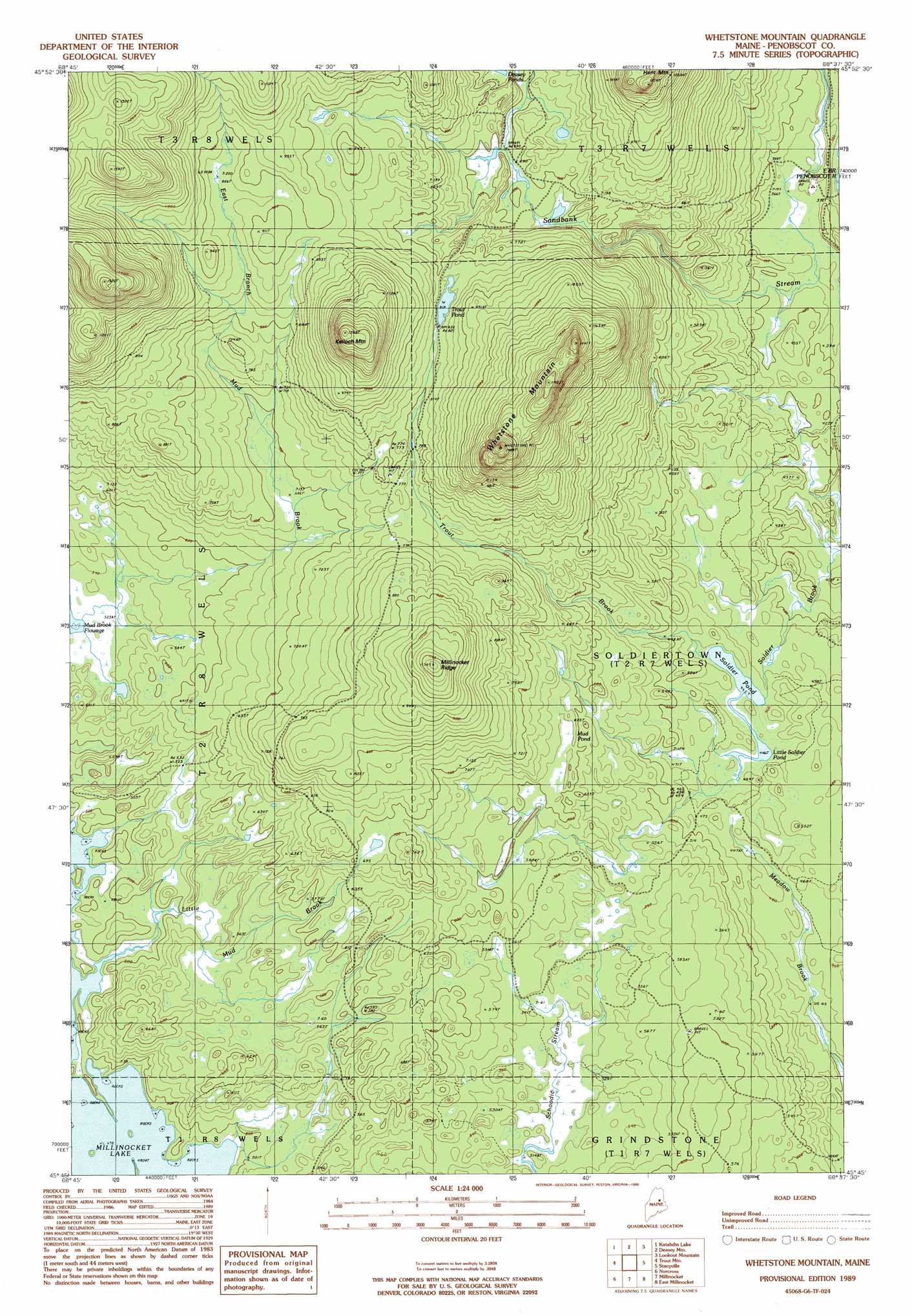
USGS Topo Quad 45068g6 - 1:24,000 scale
| Topo Map Name: | Whetstone Mountain |
| USGS Topo Quad ID: | 45068g6 |
| Print Size: | ca. 21 1/4" wide x 27" high |
| Southeast Coordinates: | 45.75° N latitude / 68.625° W longitude |
| Map Center Coordinates: | 45.8125° N latitude / 68.6875° W longitude |
| U.S. State: | ME |
| Filename: | o45068g6.jpg |
| Download Map JPG Image: | Whetstone Mountain topo map 1:24,000 scale |
| Map Type: | Topographic |
| Topo Series: | 7.5´ |
| Map Scale: | 1:24,000 |
| Source of Map Images: | United States Geological Survey (USGS) |
| Alternate Map Versions: |
Stacyville SW ME 1975, updated 1980 Download PDF Buy paper map Whetstone Mountain ME 1989, updated 1989 Download PDF Buy paper map Whetstone Mountain ME 2011 Download PDF Buy paper map Whetstone Mountain ME 2014 Download PDF Buy paper map |
1:24,000 Topo Quads surrounding Whetstone Mountain
Wassataquoik Lake |
The Traveler |
Bowlin Brook |
Shin Pond |
Mount Chase |
Mount Katahdin |
Katahdin Lake |
Deasey Mountain |
Lookout Mountain |
Patten |
Abol Pond |
Trout Mountain |
Whetstone Mountain |
Stacyville |
Benedicta |
Pemadumcook Lake |
Norcross |
Millinocket |
East Millinocket |
Salmon Stream Lake |
Ragged Mountain |
Cedar Lake |
Nollesemic Lake |
Medunkeunk Lake |
Mattaseunk Lake |
> Back to 45068e1 at 1:100,000 scale
> Back to 45068a1 at 1:250,000 scale
> Back to U.S. Topo Maps home
Whetstone Mountain topo map: Gazetteer
Whetstone Mountain: Lakes
Little Soldier Pond elevation 136m 446′Mud Brook Flowage elevation 162m 531′
Mud Pond elevation 189m 620′
Soldier Pond elevation 135m 442′
Trout Pond elevation 249m 816′
Whetstone Mountain: Ridges
Millinocket Ridge elevation 349m 1145′Whetstone Mountain: Streams
East Branch Mud Brook elevation 163m 534′Little Mud Brook elevation 146m 479′
Trout Brook elevation 136m 446′
Whetstone Mountain: Summits
Kelloch Mountain elevation 417m 1368′Whetstone Mountain elevation 447m 1466′
Whetstone Mountain: Trails
Sandbank Trail elevation 235m 770′Whetstone Mountain digital topo map on disk
Buy this Whetstone Mountain topo map showing relief, roads, GPS coordinates and other geographical features, as a high-resolution digital map file on DVD:
Maine, New Hampshire, Rhode Island & Eastern Massachusetts
Buy digital topo maps: Maine, New Hampshire, Rhode Island & Eastern Massachusetts