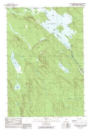
Mattawamkeag Lake Topo Map Maine
To zoom in, hover over the map of Mattawamkeag Lake
USGS Topo Quad 45068h2 - 1:24,000 scale
| Topo Map Name: | Mattawamkeag Lake |
| USGS Topo Quad ID: | 45068h2 |
| Print Size: | ca. 21 1/4" wide x 27" high |
| Southeast Coordinates: | 45.875° N latitude / 68.125° W longitude |
| Map Center Coordinates: | 45.9375° N latitude / 68.1875° W longitude |
| U.S. State: | ME |
| Filename: | o45068h2.jpg |
| Download Map JPG Image: | Mattawamkeag Lake topo map 1:24,000 scale |
| Map Type: | Topographic |
| Topo Series: | 7.5´ |
| Map Scale: | 1:24,000 |
| Source of Map Images: | United States Geological Survey (USGS) |
| Alternate Map Versions: |
Mattawamkeag Lake NW ME 1975, updated 1980 Download PDF Buy paper map Mattawamkeag Lake ME 1989, updated 1989 Download PDF Buy paper map Mattawamkeag Lake ME 2011 Download PDF Buy paper map Mattawamkeag Lake ME 2014 Download PDF Buy paper map |
1:24,000 Topo Quads surrounding Mattawamkeag Lake
> Back to 45068e1 at 1:100,000 scale
> Back to 45068a1 at 1:250,000 scale
> Back to U.S. Topo Maps home
Mattawamkeag Lake topo map: Gazetteer
Mattawamkeag Lake: Bars
Loon Ledge elevation 131m 429′Mattawamkeag Lake: Bays
Greenlaw Cove elevation 131m 429′Hamiltons Mistake elevation 132m 433′
Sand Cove elevation 131m 429′
The Pocket elevation 135m 442′
West Cove elevation 131m 429′
Mattawamkeag Lake: Capes
Bible Point elevation 124m 406′Birch Point elevation 131m 429′
Black Point elevation 132m 433′
Hitching Post Point elevation 134m 439′
Hook Point elevation 131m 429′
Long Point elevation 131m 429′
Mosquito Point elevation 132m 433′
Mattawamkeag Lake: Channels
The Thorofare elevation 131m 429′Mattawamkeag Lake: Islands
Big Island elevation 138m 452′Bug Island elevation 131m 429′
Norway Island elevation 134m 439′
Round Island elevation 131m 429′
Mattawamkeag Lake: Lakes
Caribou Lake elevation 164m 538′Mattawamkeag Lake elevation 131m 429′
Mud Lake elevation 149m 488′
Mud Pond elevation 140m 459′
Otter Lake elevation 166m 544′
Mattawamkeag Lake: Ridges
Hurricane Ridge elevation 203m 666′Pettingill Ridge elevation 175m 574′
Tapley Ridge elevation 204m 669′
Mattawamkeag Lake: Streams
First Brook elevation 125m 410′Little Sly Brook elevation 148m 485′
Trueworthy Brook elevation 132m 433′
Mattawamkeag Lake: Summits
Devils Wall elevation 140m 459′Mattawamkeag Lake: Swamps
Bush Bog elevation 213m 698′Soucier Bog elevation 140m 459′
Mattawamkeag Lake digital topo map on disk
Buy this Mattawamkeag Lake topo map showing relief, roads, GPS coordinates and other geographical features, as a high-resolution digital map file on DVD:
Maine, New Hampshire, Rhode Island & Eastern Massachusetts
Buy digital topo maps: Maine, New Hampshire, Rhode Island & Eastern Massachusetts


