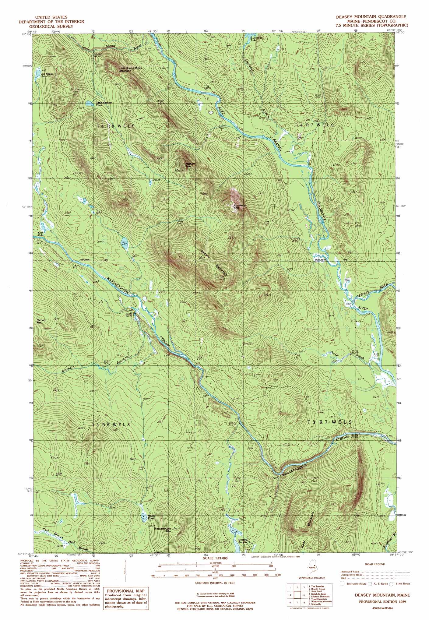
Deasey Mountain Topo Map Maine
To zoom in, hover over the map of Deasey Mountain
USGS Topo Quad 45068h6 - 1:24,000 scale
| Topo Map Name: | Deasey Mountain |
| USGS Topo Quad ID: | 45068h6 |
| Print Size: | ca. 21 1/4" wide x 27" high |
| Southeast Coordinates: | 45.875° N latitude / 68.625° W longitude |
| Map Center Coordinates: | 45.9375° N latitude / 68.6875° W longitude |
| U.S. State: | ME |
| Filename: | o45068h6.jpg |
| Download Map JPG Image: | Deasey Mountain topo map 1:24,000 scale |
| Map Type: | Topographic |
| Topo Series: | 7.5´ |
| Map Scale: | 1:24,000 |
| Source of Map Images: | United States Geological Survey (USGS) |
| Alternate Map Versions: |
Stacyville NW ME 1975, updated 1980 Download PDF Buy paper map Deasey Mountain ME 1989, updated 1989 Download PDF Buy paper map Deaxsey Mountain ME 1989, updated 1989 Download PDF Buy paper map Deasey Mountain ME 2011 Download PDF Buy paper map Deasey Mountain ME 2014 Download PDF Buy paper map |
1:24,000 Topo Quads surrounding Deasey Mountain
Frost Pond |
Trout Brook Mountain |
Hay Lake |
Hay Brook Mountain |
Green Mountain |
Wassataquoik Lake |
The Traveler |
Bowlin Brook |
Shin Pond |
Mount Chase |
Mount Katahdin |
Katahdin Lake |
Deasey Mountain |
Lookout Mountain |
Patten |
Abol Pond |
Trout Mountain |
Whetstone Mountain |
Stacyville |
Benedicta |
Pemadumcook Lake |
Norcross |
Millinocket |
East Millinocket |
Salmon Stream Lake |
> Back to 45068e1 at 1:100,000 scale
> Back to 45068a1 at 1:250,000 scale
> Back to U.S. Topo Maps home
Deasey Mountain topo map: Gazetteer
Deasey Mountain: Falls
Gilman Falls elevation 498m 1633′Orin Falls elevation 196m 643′
Deasey Mountain: Lakes
Big Robar Pond elevation 259m 849′Deasey Ponds elevation 202m 662′
Little Hathorn Pond elevation 260m 853′
Moose Pond elevation 308m 1010′
Deasey Mountain: Streams
Katahdin Brook elevation 180m 590′Lunksoos Stream elevation 115m 377′
Owen Brook elevation 106m 347′
Seboeis River elevation 106m 347′
Deasey Mountain: Summits
Deasey Mountain elevation 589m 1932′Hathorn Mountain elevation 444m 1456′
Hunt Mountain elevation 447m 1466′
Little Spring Brook Mountain elevation 332m 1089′
Lunksoos Mountain elevation 535m 1755′
Wassataquoik Mountain elevation 417m 1368′
Deasey Mountain: Trails
Spring Brook Trail elevation 283m 928′Telos Tote Road elevation 116m 380′
Deasey Mountain digital topo map on disk
Buy this Deasey Mountain topo map showing relief, roads, GPS coordinates and other geographical features, as a high-resolution digital map file on DVD:
Maine, New Hampshire, Rhode Island & Eastern Massachusetts
Buy digital topo maps: Maine, New Hampshire, Rhode Island & Eastern Massachusetts