Cambridge Topo Map Maine
To zoom in, hover over the map of Cambridge
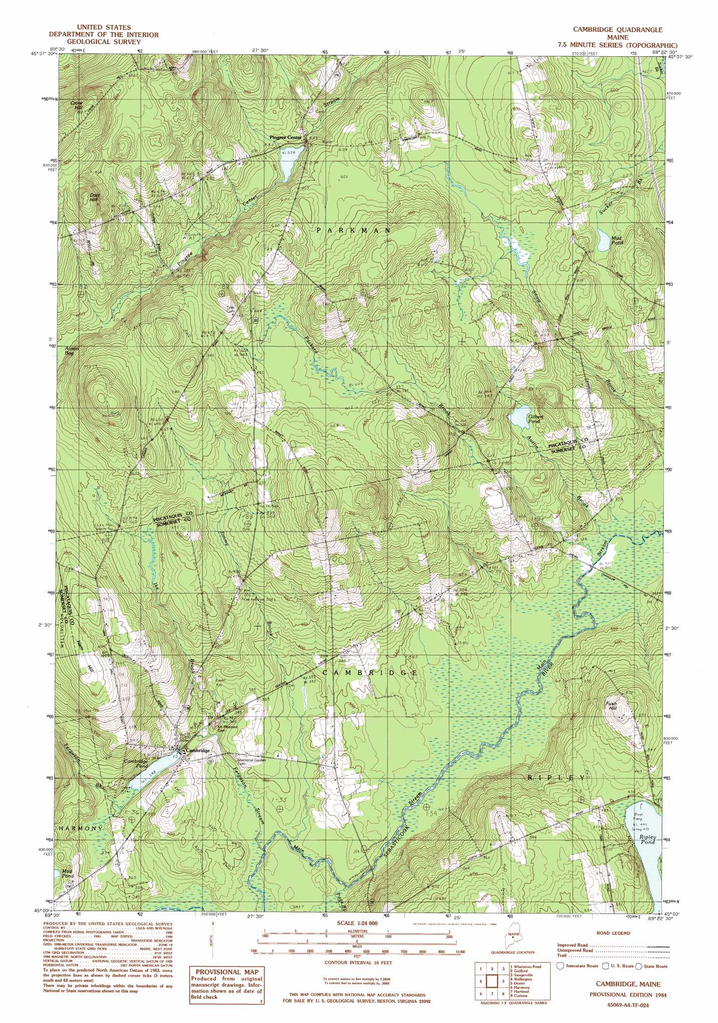
USGS Topo Quad 45069a4 - 1:24,000 scale
| Topo Map Name: | Cambridge |
| USGS Topo Quad ID: | 45069a4 |
| Print Size: | ca. 21 1/4" wide x 27" high |
| Southeast Coordinates: | 45° N latitude / 69.375° W longitude |
| Map Center Coordinates: | 45.0625° N latitude / 69.4375° W longitude |
| U.S. State: | ME |
| Filename: | o45069a4.jpg |
| Download Map JPG Image: | Cambridge topo map 1:24,000 scale |
| Map Type: | Topographic |
| Topo Series: | 7.5´ |
| Map Scale: | 1:24,000 |
| Source of Map Images: | United States Geological Survey (USGS) |
| Alternate Map Versions: |
Guilford SW ME 1975, updated 1980 Download PDF Buy paper map Cambridge ME 1984, updated 1984 Download PDF Buy paper map Cambridge ME 2011 Download PDF Buy paper map Cambridge ME 2014 Download PDF Buy paper map |
1:24,000 Topo Quads surrounding Cambridge
Bald Mountain Pond |
Monson West |
Monson East |
Sebec Lake West |
Sebec Lake East |
Foster Ridge |
Whetstone Pond |
Guilford |
Sangerville |
Dover-Foxcroft |
Kingsbury |
Wellington |
Cambridge |
Dexter |
Garland |
Arbens |
Harmony |
Hartland |
Corinna |
Stetson |
Skowhegan |
Canaan |
Pittsfield |
Newport |
Plymouth |
> Back to 45069a1 at 1:100,000 scale
> Back to 45068a1 at 1:250,000 scale
> Back to U.S. Topo Maps home
Cambridge topo map: Gazetteer
Cambridge: Airports
Greenfield Hill Airport elevation 200m 656′Cambridge: Dams
Cambridge Pond Dam elevation 106m 347′Pingree Dam elevation 161m 528′
Cambridge: Lakes
Gilbert Pond elevation 148m 485′Mud Pond elevation 169m 554′
Cambridge: Populated Places
Cambridge elevation 105m 344′Pingree Center elevation 162m 531′
Cambridge: Reservoirs
Cambridge Pond elevation 106m 347′Pingree Pond elevation 161m 528′
Cambridge: Streams
Austin Brook elevation 96m 314′Ferguson Brook elevation 106m 347′
Ferguson Stream elevation 94m 308′
Ike Brook elevation 99m 324′
Jimmy Brook elevation 97m 318′
Main Stream Sebasticook River elevation 94m 308′
Packard Brook elevation 96m 314′
Page Brook elevation 96m 314′
Cambridge: Summits
Dorr Hill elevation 290m 951′Fush Hill elevation 191m 626′
Ham Hill elevation 211m 692′
Cambridge digital topo map on disk
Buy this Cambridge topo map showing relief, roads, GPS coordinates and other geographical features, as a high-resolution digital map file on DVD:
Maine, New Hampshire, Rhode Island & Eastern Massachusetts
Buy digital topo maps: Maine, New Hampshire, Rhode Island & Eastern Massachusetts