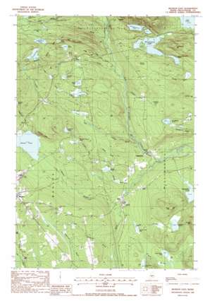
Monson East Topo Map Maine
To zoom in, hover over the map of Monson East
USGS Topo Quad 45069c4 - 1:24,000 scale
| Topo Map Name: | Monson East |
| USGS Topo Quad ID: | 45069c4 |
| Print Size: | ca. 21 1/4" wide x 27" high |
| Southeast Coordinates: | 45.25° N latitude / 69.375° W longitude |
| Map Center Coordinates: | 45.3125° N latitude / 69.4375° W longitude |
| U.S. State: | ME |
| Filename: | o45069c4.jpg |
| Download Map JPG Image: | Monson East topo map 1:24,000 scale |
| Map Type: | Topographic |
| Topo Series: | 7.5´ |
| Map Scale: | 1:24,000 |
| Source of Map Images: | United States Geological Survey (USGS) |
| Alternate Map Versions: |
Monson East ME 1977, updated 1981 Download PDF Buy paper map Monson East ME 1988, updated 1988 Download PDF Buy paper map Monson East ME 2011 Download PDF Buy paper map Monson East ME 2014 Download PDF Buy paper map |
1:24,000 Topo Quads surrounding Monson East
> Back to 45069a1 at 1:100,000 scale
> Back to 45068a1 at 1:250,000 scale
> Back to U.S. Topo Maps home
Monson East topo map: Gazetteer
Monson East: Basins
Beetham Swale elevation 218m 715′Monson East: Benches
Bear Pond Ledge elevation 365m 1197′Wariners Ledges elevation 268m 879′
Monson East: Dams
Phillips Brooks Dam elevation 256m 839′Monson East: Falls
Little Wilson Falls elevation 261m 856′Monson East: Lakes
Badger Pond elevation 134m 439′Bear Pond elevation 268m 879′
Big Greenwood Pond elevation 202m 662′
Eighteen Pond elevation 229m 751′
Eighteen Quarry Pond elevation 222m 728′
Fourth Davis Pond elevation 147m 482′
Grindstone Pond elevation 198m 649′
Horseshoe Pond elevation 163m 534′
Juniper Knee Pond elevation 299m 980′
Little Greenwood Pond elevation 202m 662′
Meadow Pond elevation 235m 770′
Monson Pond elevation 188m 616′
Mud Greenwood Pond elevation 201m 659′
Mud Pond elevation 312m 1023′
North Pond elevation 312m 1023′
Poverty Pond elevation 178m 583′
South Pond elevation 210m 688′
Squankin Pond elevation 210m 688′
Third Davis Pond elevation 140m 459′
Monson East: Mines
Farm Quarry Number One elevation 244m 800′Farm Quarry Number Two elevation 262m 859′
Hillside Quarry elevation 297m 974′
Kineo Quarry elevation 215m 705′
Monson East: Populated Places
Bodfish elevation 217m 711′Goodell Corner elevation 114m 374′
Willimantic elevation 129m 423′
Monson East: Reservoirs
Lake Hebron elevation 256m 839′Monson East: Streams
Badger Brook elevation 136m 446′Bear Pond Brook elevation 142m 465′
Davis Brook elevation 111m 364′
Eighteen Pond Brook elevation 136m 446′
Goodell Brook elevation 194m 636′
Hammond Brook elevation 121m 396′
Hathaway Brook elevation 114m 374′
James Brook elevation 145m 475′
Ledge Hill Brook elevation 141m 462′
Leeman Brook elevation 122m 400′
Monson Stream elevation 114m 374′
North Pond Brook elevation 211m 692′
Peppermint Brook elevation 188m 616′
Poverty Brook elevation 115m 377′
Prescott Brook elevation 120m 393′
Prescott Brook elevation 136m 446′
Monson East: Summits
Davis Mountain elevation 290m 951′Greenwood Mountain elevation 344m 1128′
Ledge Hill elevation 235m 770′
Poverty Mountain elevation 311m 1020′
Monson East: Swamps
Doughty Bog elevation 171m 561′Fourth Pond Bog elevation 143m 469′
Gilman Swamp elevation 242m 793′
Juniper Knee Bog elevation 291m 954′
Long Bog elevation 214m 702′
Monson East digital topo map on disk
Buy this Monson East topo map showing relief, roads, GPS coordinates and other geographical features, as a high-resolution digital map file on DVD:
Maine, New Hampshire, Rhode Island & Eastern Massachusetts
Buy digital topo maps: Maine, New Hampshire, Rhode Island & Eastern Massachusetts


