Bald Mountain Pond Topo Map Maine
To zoom in, hover over the map of Bald Mountain Pond
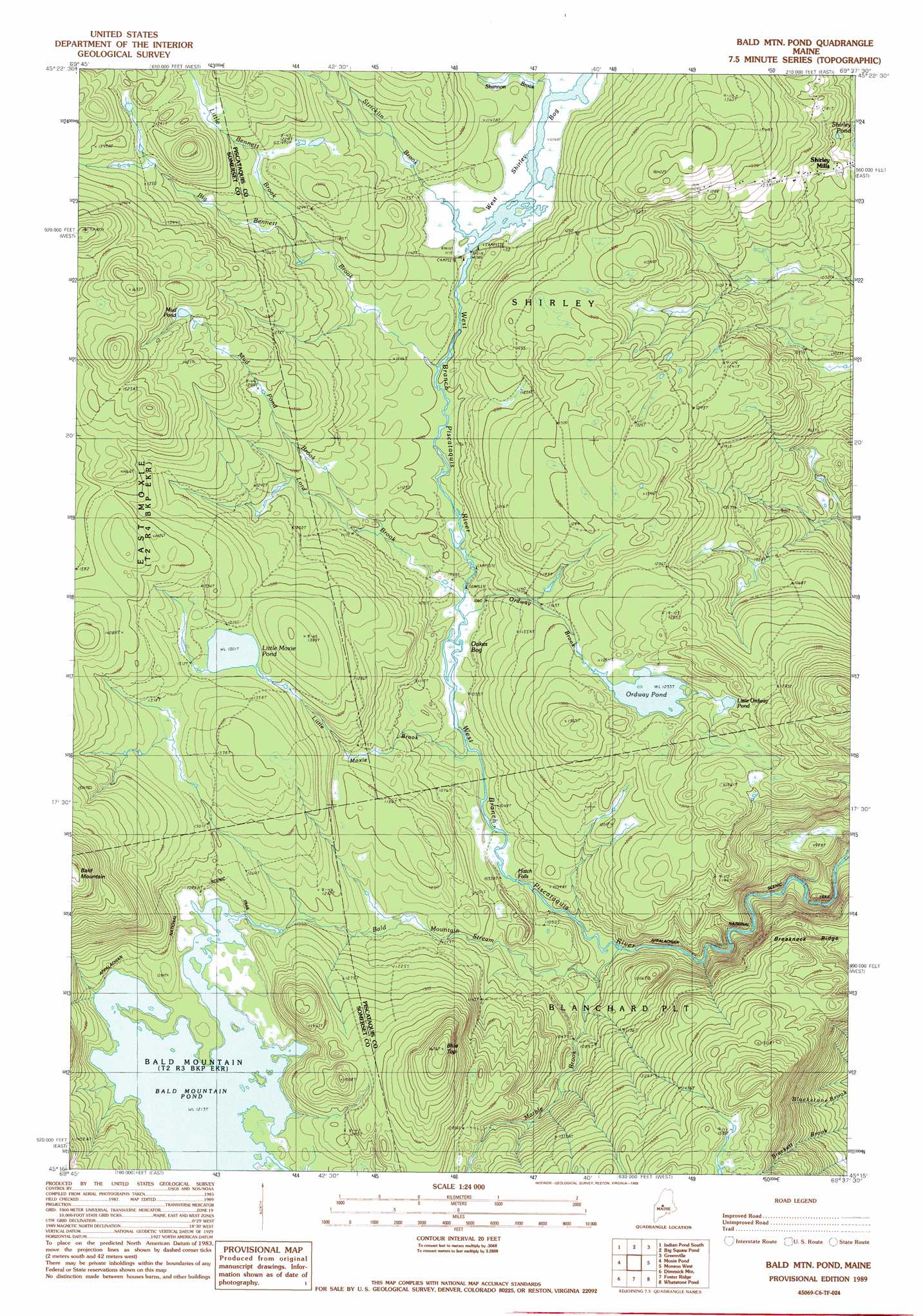
USGS Topo Quad 45069c6 - 1:24,000 scale
| Topo Map Name: | Bald Mountain Pond |
| USGS Topo Quad ID: | 45069c6 |
| Print Size: | ca. 21 1/4" wide x 27" high |
| Southeast Coordinates: | 45.25° N latitude / 69.625° W longitude |
| Map Center Coordinates: | 45.3125° N latitude / 69.6875° W longitude |
| U.S. State: | ME |
| Filename: | o45069c6.jpg |
| Download Map JPG Image: | Bald Mountain Pond topo map 1:24,000 scale |
| Map Type: | Topographic |
| Topo Series: | 7.5´ |
| Map Scale: | 1:24,000 |
| Source of Map Images: | United States Geological Survey (USGS) |
| Alternate Map Versions: |
Bald Mountain Pond ME 1977, updated 1981 Download PDF Buy paper map Bald Mtn Pond ME 1989, updated 1989 Download PDF Buy paper map Bald Mountain Pond ME 2011 Download PDF Buy paper map Bald Mountain Pond ME 2014 Download PDF Buy paper map |
1:24,000 Topo Quads surrounding Bald Mountain Pond
Misery Knob |
Indian Pond North |
Moosehead |
Lily Bay |
Number Four Mountain |
Black Brook Pond |
Indian Pond South |
Big Squaw Pond |
Greenville |
Barren Mountain West |
The Forks |
Moxie Pond |
Bald Mountain Pond |
Monson West |
Monson East |
Caratunk |
Dimmick Mountain |
Foster Ridge |
Whetstone Pond |
Guilford |
Bingham |
Mahoney Hill |
Kingsbury |
Wellington |
Cambridge |
> Back to 45069a1 at 1:100,000 scale
> Back to 45068a1 at 1:250,000 scale
> Back to U.S. Topo Maps home
Bald Mountain Pond topo map: Gazetteer
Bald Mountain Pond: Falls
Hatch Falls elevation 309m 1013′Bald Mountain Pond: Lakes
Bald Mountain Pond elevation 370m 1213′Little Moxie Pond elevation 396m 1299′
Little Ordway Pond elevation 387m 1269′
Mud Pond elevation 429m 1407′
Ordway Pond elevation 375m 1230′
West Shirley Bog elevation 338m 1108′
Bald Mountain Pond: Ridges
Breakneck Ridge elevation 372m 1220′Bald Mountain Pond: Streams
Bald Mountain Stream elevation 295m 967′Big Bennett Brook elevation 334m 1095′
East Inlet Bald Mountain Pond elevation 370m 1213′
Little Bennett Brook elevation 357m 1171′
Little Moxie Brook elevation 316m 1036′
Lord Brook elevation 322m 1056′
Marble Brook elevation 299m 980′
Mud Pond Brook elevation 332m 1089′
Ordway Brook elevation 321m 1053′
Shannon Brook elevation 340m 1115′
Stricklin Brook elevation 338m 1108′
Bald Mountain Pond: Summits
Blue Top elevation 507m 1663′Bald Mountain Pond: Swamps
Oakes Bog elevation 320m 1049′Bald Mountain Pond digital topo map on disk
Buy this Bald Mountain Pond topo map showing relief, roads, GPS coordinates and other geographical features, as a high-resolution digital map file on DVD:
Maine, New Hampshire, Rhode Island & Eastern Massachusetts
Buy digital topo maps: Maine, New Hampshire, Rhode Island & Eastern Massachusetts