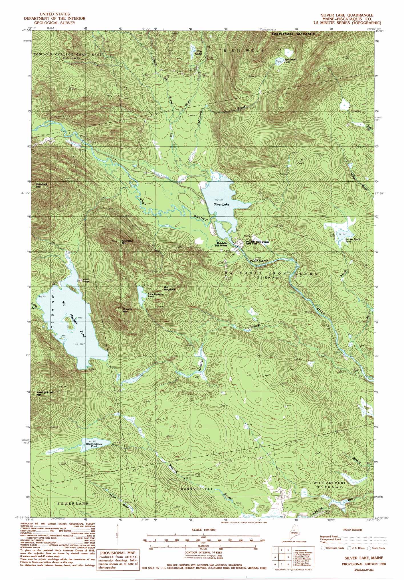
Silver Lake Topo Map Maine
To zoom in, hover over the map of Silver Lake
USGS Topo Quad 45069d2 - 1:24,000 scale
| Topo Map Name: | Silver Lake |
| USGS Topo Quad ID: | 45069d2 |
| Print Size: | ca. 21 1/4" wide x 27" high |
| Southeast Coordinates: | 45.375° N latitude / 69.125° W longitude |
| Map Center Coordinates: | 45.4375° N latitude / 69.1875° W longitude |
| U.S. State: | ME |
| Filename: | o45069d2.jpg |
| Download Map JPG Image: | Silver Lake topo map 1:24,000 scale |
| Map Type: | Topographic |
| Topo Series: | 7.5´ |
| Map Scale: | 1:24,000 |
| Source of Map Images: | United States Geological Survey (USGS) |
| Alternate Map Versions: |
Silver Lake ME 1978, updated 1981 Download PDF Buy paper map Silver Lake ME 1988, updated 1988 Download PDF Buy paper map Silver Lake ME 2011 Download PDF Buy paper map Silver Lake ME 2014 Download PDF Buy paper map |
1:24,000 Topo Quads surrounding Silver Lake
Kokadjo |
Farrar Mountain |
Wadleigh Mountain |
Nahmakanta Stream |
Pemadumcook Lake |
Number Four Mountain |
Hay Mountain |
Big Shanty Mountain |
Jo-Mary Mountain |
Ragged Mountain |
Barren Mountain West |
Barren Mountain East |
Silver Lake |
Ebeemee Mountain |
Seboeis Lake |
Monson East |
Sebec Lake West |
Sebec Lake East |
Brownville Junction |
Milo North |
Guilford |
Sangerville |
Dover-Foxcroft |
South Sebec |
Milo South |
> Back to 45069a1 at 1:100,000 scale
> Back to 45068a1 at 1:250,000 scale
> Back to U.S. Topo Maps home
Silver Lake topo map: Gazetteer
Silver Lake: Lakes
Big Houston Pond elevation 250m 820′Little Houston Pond elevation 338m 1108′
Roaring Brook Pond elevation 274m 898′
Saddlerock Pond elevation 452m 1482′
Silver Lake elevation 180m 590′
Sucker Brook Pond elevation 241m 790′
Silver Lake: Parks
Katahdin Iron Works State Park elevation 177m 580′Silver Lake: Streams
Big White Brook elevation 182m 597′Houston Brook elevation 138m 452′
Indian Stream elevation 251m 823′
Page Brook elevation 215m 705′
Saddlerock Brook elevation 179m 587′
Spruce Mountain Brook elevation 189m 620′
Sucker Brook elevation 141m 462′
White Brook elevation 187m 613′
Silver Lake: Summits
Houston Mountain elevation 423m 1387′Ore Mountain elevation 364m 1194′
Roundtop Mountain elevation 408m 1338′
Silver Lake: Trails
Auburn Log Hauling Road elevation 252m 826′Silver Lake digital topo map on disk
Buy this Silver Lake topo map showing relief, roads, GPS coordinates and other geographical features, as a high-resolution digital map file on DVD:
Maine, New Hampshire, Rhode Island & Eastern Massachusetts
Buy digital topo maps: Maine, New Hampshire, Rhode Island & Eastern Massachusetts