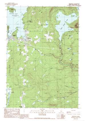
Greenville Topo Map Maine
To zoom in, hover over the map of Greenville
USGS Topo Quad 45069d5 - 1:24,000 scale
| Topo Map Name: | Greenville |
| USGS Topo Quad ID: | 45069d5 |
| Print Size: | ca. 21 1/4" wide x 27" high |
| Southeast Coordinates: | 45.375° N latitude / 69.5° W longitude |
| Map Center Coordinates: | 45.4375° N latitude / 69.5625° W longitude |
| U.S. State: | ME |
| Filename: | o45069d5.jpg |
| Download Map JPG Image: | Greenville topo map 1:24,000 scale |
| Map Type: | Topographic |
| Topo Series: | 7.5´ |
| Map Scale: | 1:24,000 |
| Source of Map Images: | United States Geological Survey (USGS) |
| Alternate Map Versions: |
Greenville ME 1977, updated 1981 Download PDF Buy paper map Greenville ME 1989, updated 1989 Download PDF Buy paper map Greenville ME 1989, updated 1989 Download PDF Buy paper map Greenville ME 2011 Download PDF Buy paper map Greenville ME 2014 Download PDF Buy paper map |
1:24,000 Topo Quads surrounding Greenville
> Back to 45069a1 at 1:100,000 scale
> Back to 45068a1 at 1:250,000 scale
> Back to U.S. Topo Maps home
Greenville topo map: Gazetteer
Greenville: Airports
Greenville Forestry Seaplane Base elevation 313m 1026′Greenville Municipal Airport elevation 425m 1394′
Greenville Seaplane Base elevation 322m 1056′
Greenville: Bays
Rum Cove elevation 342m 1122′West Cove elevation 313m 1026′
Greenville: Capes
Birch Point elevation 347m 1138′Cove Point elevation 322m 1056′
Harfords Point elevation 329m 1079′
West Cove Point elevation 316m 1036′
Greenville: Dams
Lower Wilson Pond Dam elevation 342m 1122′Pestock Dam elevation 339m 1112′
Greenville: Islands
Teasdale Island elevation 349m 1145′Greenville: Lakes
Grenell Pond elevation 392m 1286′Mud Pond elevation 331m 1085′
Salmon Pond elevation 368m 1207′
Sawyer Pond elevation 380m 1246′
Secret Pond elevation 388m 1272′
Shadow Pond elevation 323m 1059′
Greenville: Populated Places
Greenville elevation 318m 1043′Greenville Junction elevation 317m 1040′
The Highlands elevation 373m 1223′
Upper Shirley Corner elevation 380m 1246′
Greenville: Post Offices
Greenville Junction Post Office elevation 324m 1062′Greenville Post Office (historical) elevation 317m 1040′
Greenville: Reservoirs
Big Wilson Stream Reservoir elevation 338m 1108′Lower Wilson Pond elevation 342m 1122′
Greenville: Ridges
Oak Ridge elevation 490m 1607′Greenville: Streams
Coffee House Stream elevation 254m 833′Eagle Stream elevation 277m 908′
Mill Brook elevation 316m 1036′
Rum Brook elevation 343m 1125′
Greenville: Summits
Blair Hill elevation 560m 1837′Indian Hill elevation 396m 1299′
Rum Mountain elevation 582m 1909′
Greenville: Swamps
East Shirley Bog elevation 322m 1056′Greenville digital topo map on disk
Buy this Greenville topo map showing relief, roads, GPS coordinates and other geographical features, as a high-resolution digital map file on DVD:
Maine, New Hampshire, Rhode Island & Eastern Massachusetts
Buy digital topo maps: Maine, New Hampshire, Rhode Island & Eastern Massachusetts


