Wadleigh Mountain Topo Map Maine
To zoom in, hover over the map of Wadleigh Mountain
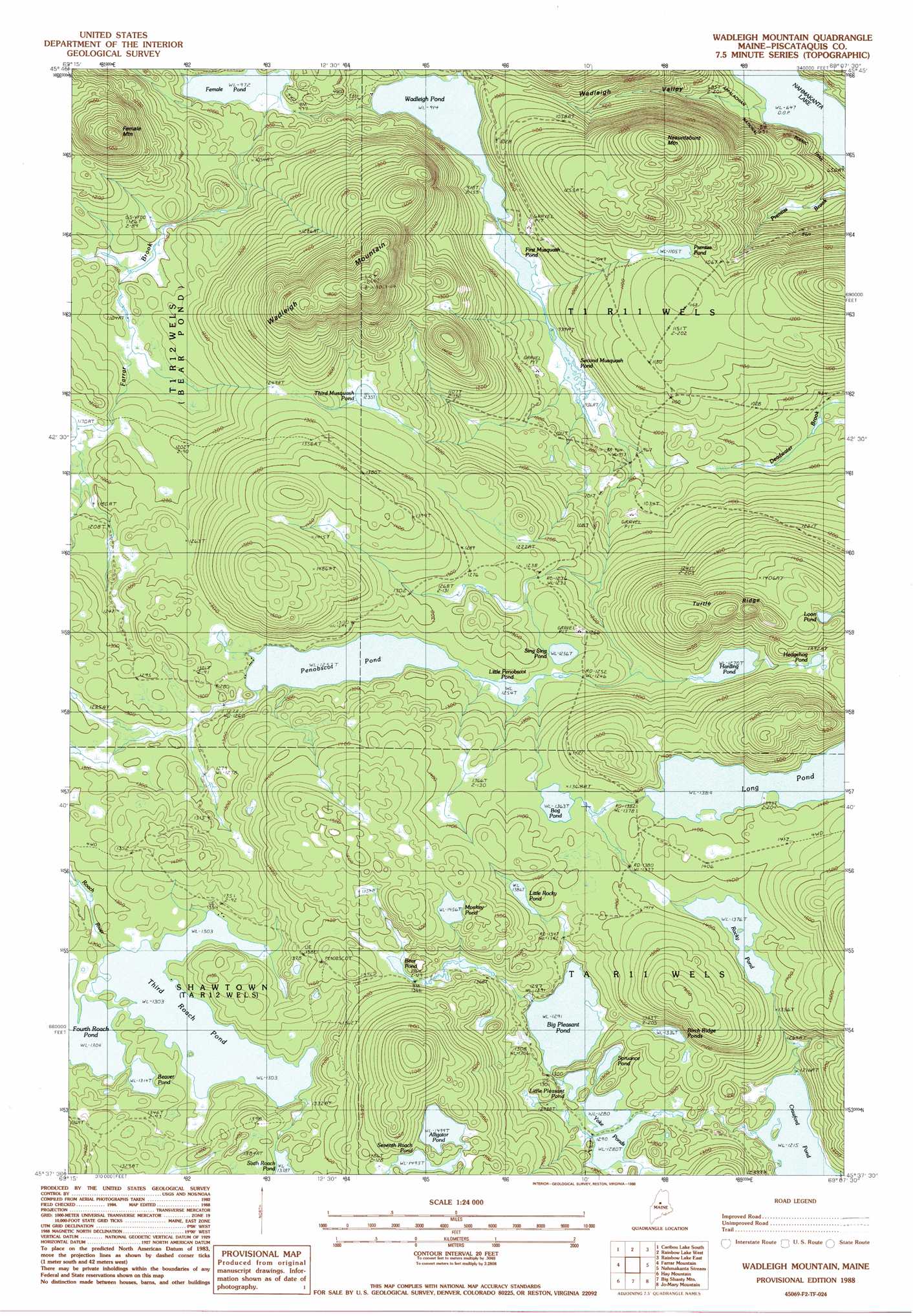
USGS Topo Quad 45069f2 - 1:24,000 scale
| Topo Map Name: | Wadleigh Mountain |
| USGS Topo Quad ID: | 45069f2 |
| Print Size: | ca. 21 1/4" wide x 27" high |
| Southeast Coordinates: | 45.625° N latitude / 69.125° W longitude |
| Map Center Coordinates: | 45.6875° N latitude / 69.1875° W longitude |
| U.S. State: | ME |
| Filename: | o45069f2.jpg |
| Download Map JPG Image: | Wadleigh Mountain topo map 1:24,000 scale |
| Map Type: | Topographic |
| Topo Series: | 7.5´ |
| Map Scale: | 1:24,000 |
| Source of Map Images: | United States Geological Survey (USGS) |
| Alternate Map Versions: |
Wadleigh Mountain ME 1978, updated 1981 Download PDF Buy paper map Wadleigh Mountain ME 1988, updated 1988 Download PDF Buy paper map Wadleigh Mountain ME 2011 Download PDF Buy paper map Wadleigh Mountain ME 2014 Download PDF Buy paper map |
1:24,000 Topo Quads surrounding Wadleigh Mountain
Pine Stream Flowage |
Caribou Lake North |
Harrington Lake |
Doubletop Mountain |
Mount Katahdin |
Big Spencer Mountain |
Caribou Lake South |
Rainbow Lake West |
Rainbow Lake East |
Abol Pond |
Kokadjo |
Farrar Mountain |
Wadleigh Mountain |
Nahmakanta Stream |
Pemadumcook Lake |
Number Four Mountain |
Hay Mountain |
Big Shanty Mountain |
Jo-Mary Mountain |
Ragged Mountain |
Barren Mountain West |
Barren Mountain East |
Silver Lake |
Ebeemee Mountain |
Seboeis Lake |
> Back to 45069e1 at 1:100,000 scale
> Back to 45068a1 at 1:250,000 scale
> Back to U.S. Topo Maps home
Wadleigh Mountain topo map: Gazetteer
Wadleigh Mountain: Lakes
Alligator Pond elevation 455m 1492′Bear Pond elevation 418m 1371′
Beaver Pond elevation 400m 1312′
Big Pleasant Pond elevation 395m 1295′
Birch Ridge Ponds elevation 405m 1328′
Bog Pond elevation 415m 1361′
Crawford Pond elevation 370m 1213′
Female Pond elevation 296m 971′
First Musquash Pond elevation 282m 925′
Hedgehog Pond elevation 403m 1322′
Little Penobscot Pond elevation 382m 1253′
Little Pleasant Pond elevation 394m 1292′
Little Rocky Pond elevation 423m 1387′
Long Pond elevation 423m 1387′
Loon Pond elevation 451m 1479′
Monkey Pond elevation 443m 1453′
Penobscot Pond elevation 383m 1256′
Prentiss Pond elevation 339m 1112′
Rocky Pond elevation 417m 1368′
Second Musquash Pond elevation 283m 928′
Seventh Roach Pond elevation 456m 1496′
Sing Sing Pond elevation 386m 1266′
Spruance Pond elevation 405m 1328′
Third Musquash Pond elevation 375m 1230′
Third Roach Pond elevation 401m 1315′
Wadleigh Pond elevation 280m 918′
Yoke Ponds elevation 392m 1286′
Wadleigh Mountain: Reservoirs
Harding Pond elevation 386m 1266′Wadleigh Mountain: Ridges
Turtle Ridge elevation 494m 1620′Wadleigh Mountain: Streams
Farrar Brook elevation 296m 971′Wadleigh Mountain: Summits
Female Mountain elevation 505m 1656′Nesuntabunt Mountain elevation 438m 1437′
Wadleigh Mountain elevation 562m 1843′
Wadleigh Mountain: Valleys
Wadleigh Valley elevation 218m 715′Wadleigh Mountain digital topo map on disk
Buy this Wadleigh Mountain topo map showing relief, roads, GPS coordinates and other geographical features, as a high-resolution digital map file on DVD:
Maine, New Hampshire, Rhode Island & Eastern Massachusetts
Buy digital topo maps: Maine, New Hampshire, Rhode Island & Eastern Massachusetts