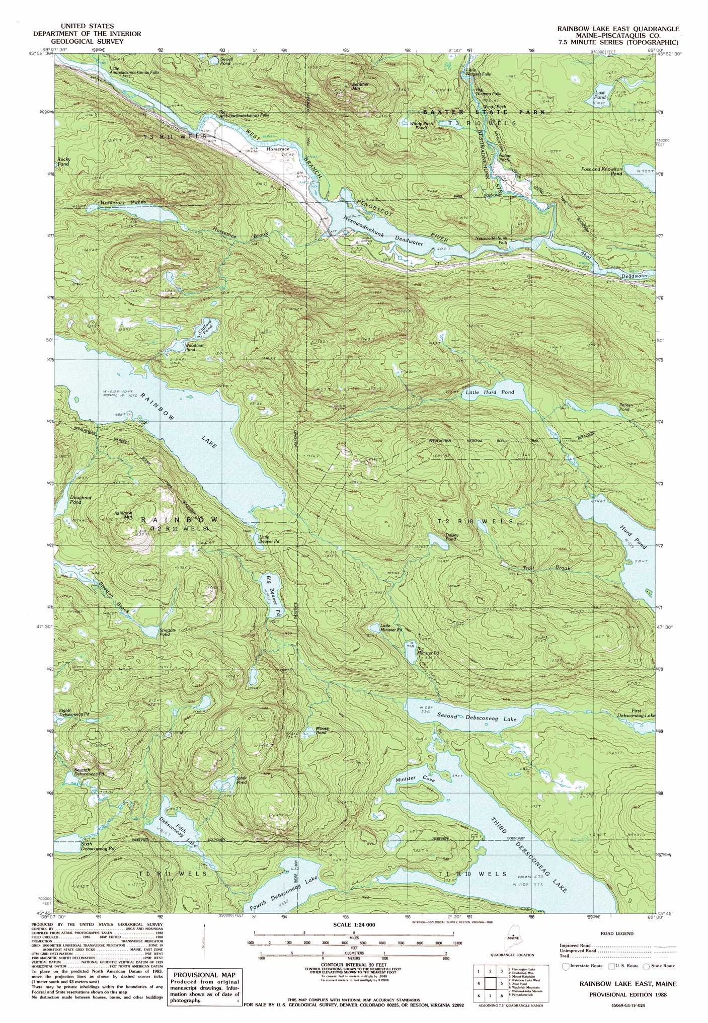
Rainbow Lake East Topo Map Maine
To zoom in, hover over the map of Rainbow Lake East
USGS Topo Quad 45069g1 - 1:24,000 scale
| Topo Map Name: | Rainbow Lake East |
| USGS Topo Quad ID: | 45069g1 |
| Print Size: | ca. 21 1/4" wide x 27" high |
| Southeast Coordinates: | 45.75° N latitude / 69° W longitude |
| Map Center Coordinates: | 45.8125° N latitude / 69.0625° W longitude |
| U.S. State: | ME |
| Filename: | o45069g1.jpg |
| Download Map JPG Image: | Rainbow Lake East topo map 1:24,000 scale |
| Map Type: | Topographic |
| Topo Series: | 7.5´ |
| Map Scale: | 1:24,000 |
| Source of Map Images: | United States Geological Survey (USGS) |
| Alternate Map Versions: |
Rainbow Lake East ME 1978, updated 1981 Download PDF Buy paper map Rainbow Lake East ME 1988, updated 1988 Download PDF Buy paper map Rainbow Lake East ME 2011 Download PDF Buy paper map Rainbow Lake East ME 2014 Download PDF Buy paper map |
1:24,000 Topo Quads surrounding Rainbow Lake East
Cuxabexis Lake |
Telos Brook |
Nesowad Nehunk Lake |
Wassataquoik Lake |
The Traveler |
Caribou Lake North |
Harrington Lake |
Doubletop Mountain |
Mount Katahdin |
Katahdin Lake |
Caribou Lake South |
Rainbow Lake West |
Rainbow Lake East |
Abol Pond |
Trout Mountain |
Farrar Mountain |
Wadleigh Mountain |
Nahmakanta Stream |
Pemadumcook Lake |
Norcross |
Hay Mountain |
Big Shanty Mountain |
Jo-Mary Mountain |
Ragged Mountain |
Cedar Lake |
> Back to 45069e1 at 1:100,000 scale
> Back to 45068a1 at 1:250,000 scale
> Back to U.S. Topo Maps home
Rainbow Lake East topo map: Gazetteer
Rainbow Lake East: Bays
Minister Cove elevation 174m 570′Rainbow Lake East: Channels
Horserace elevation 187m 613′Rainbow Lake East: Dams
Third Debsconeag Lake Dam elevation 173m 567′Rainbow Lake East: Falls
Big Ambejackmockamus Falls elevation 195m 639′Big Niagara Falls elevation 292m 958′
Little Ambejackmockamus Falls elevation 205m 672′
Little Niagara Falls elevation 304m 997′
Nesowadnehunk Falls elevation 178m 583′
Rainbow Lake East: Lakes
Big Beaver Pond elevation 301m 987′Big Minister Pond elevation 235m 770′
Clifford Pond elevation 365m 1197′
Daisey Pond elevation 312m 1023′
Doughnut Pond elevation 379m 1243′
Fifth Debsconeag Lake elevation 247m 810′
Foss and Knowlton Pond elevation 283m 928′
Fourth Debsconeag Lake elevation 192m 629′
Horserace Ponds elevation 320m 1049′
Indian Pitch Ponds elevation 260m 853′
Little Beaver Pond elevation 325m 1066′
Little Hurd Pond elevation 223m 731′
Little Minister Pond elevation 253m 830′
Lost Pond elevation 339m 1112′
Moose Pond elevation 296m 971′
Nesowadnehunk Deadwater elevation 181m 593′
Pitman Pond elevation 245m 803′
Second Debsconeag Lake elevation 162m 531′
Seventh Debsconeag Pond elevation 307m 1007′
Sewall Pond elevation 273m 895′
Sixth Debsconeag Pond elevation 296m 971′
Stink Pond elevation 358m 1174′
Stratton Pond elevation 382m 1253′
Woodman Pond elevation 363m 1190′
Rainbow Lake East: Rapids
Indian Pitch elevation 239m 784′Windy Pitch elevation 268m 879′
Rainbow Lake East: Reservoirs
Third Debsconeag Lake elevation 173m 567′Rainbow Lake East: Streams
Horserace Brook elevation 182m 597′Nesowadnehunk Stream elevation 177m 580′
Trail Brook elevation 176m 577′
Rainbow Lake East: Summits
Rainbow Mountain elevation 501m 1643′Sentinel Mountain elevation 567m 1860′
Rainbow Lake East: Trails
Blue Trail elevation 413m 1354′Rainbow Lake East digital topo map on disk
Buy this Rainbow Lake East topo map showing relief, roads, GPS coordinates and other geographical features, as a high-resolution digital map file on DVD:
Maine, New Hampshire, Rhode Island & Eastern Massachusetts
Buy digital topo maps: Maine, New Hampshire, Rhode Island & Eastern Massachusetts