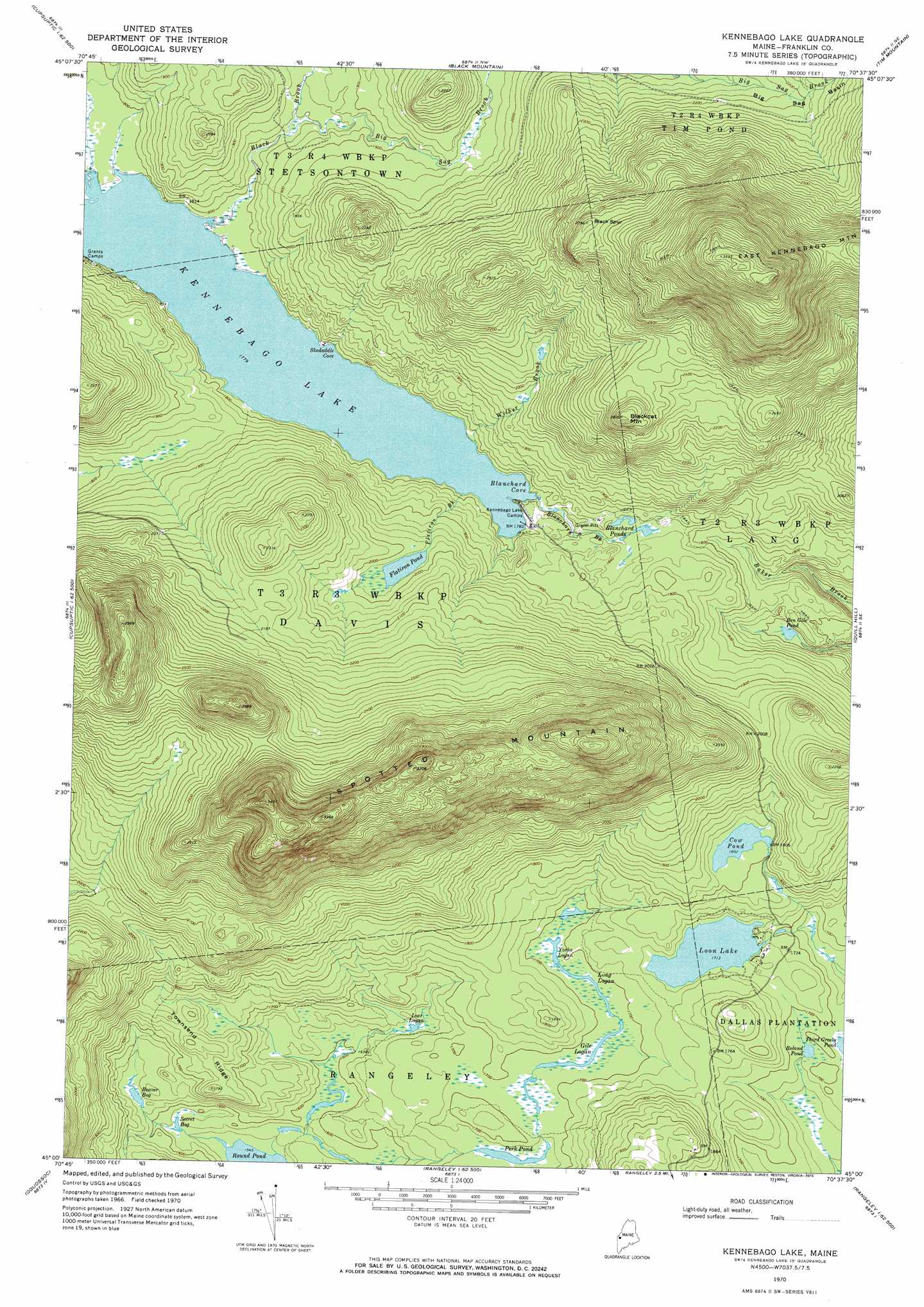
Kennebago Lake Topo Map Maine
To zoom in, hover over the map of Kennebago Lake
USGS Topo Quad 45070a6 - 1:24,000 scale
| Topo Map Name: | Kennebago Lake |
| USGS Topo Quad ID: | 45070a6 |
| Print Size: | ca. 21 1/4" wide x 27" high |
| Southeast Coordinates: | 45° N latitude / 70.625° W longitude |
| Map Center Coordinates: | 45.0625° N latitude / 70.6875° W longitude |
| U.S. State: | ME |
| Filename: | o45070a6.jpg |
| Download Map JPG Image: | Kennebago Lake topo map 1:24,000 scale |
| Map Type: | Topographic |
| Topo Series: | 7.5´ |
| Map Scale: | 1:24,000 |
| Source of Map Images: | United States Geological Survey (USGS) |
| Alternate Map Versions: |
Kennebago Lake ME 1970, updated 1973 Download PDF Buy paper map Kennebago Lake ME 1977, updated 1983 Download PDF Buy paper map Kennebago Lake ME 1997, updated 2000 Download PDF Buy paper map Kennebago Lake ME 2011 Download PDF Buy paper map Kennebago Lake ME 2014 Download PDF Buy paper map |
1:24,000 Topo Quads surrounding Kennebago Lake
Twin Peaks |
Northwest Pond |
Chain Of Ponds |
Jim Pond |
King And Bartlett Mountain |
Parmachenee Lake |
Little Kennebago Lake |
Black Mountain |
Tim Mountain |
Stratton |
Lincoln Pond |
Kennebago |
Kennebago Lake |
Quill Hill |
Black Nubble |
Richardson Pond |
Oquossoc |
Rangeley |
Saddleback Mountain |
Redington |
Middle Dam |
Metallak Mountain |
Houghton |
Jackson Mountain |
Madrid |
> Back to 45070a1 at 1:100,000 scale
> Back to 45070a1 at 1:250,000 scale
> Back to U.S. Topo Maps home
Kennebago Lake topo map: Gazetteer
Kennebago Lake: Bays
Blanchard Cove elevation 542m 1778′Skedaddle Cove elevation 542m 1778′
Kennebago Lake: Lakes
Beaver Bog elevation 497m 1630′Ben Gile Pond elevation 515m 1689′
Blanchard Ponds elevation 558m 1830′
Cow Pond elevation 549m 1801′
Flatiron Pond elevation 601m 1971′
Gile Logan elevation 514m 1686′
Long Logan elevation 514m 1686′
Loon Lake elevation 522m 1712′
Lost Logan elevation 499m 1637′
Perk Pond elevation 509m 1669′
Roland Pond elevation 515m 1689′
Secret Bog elevation 481m 1578′
Yorks Logan elevation 514m 1686′
Kennebago Lake: Populated Places
Grants Camps elevation 542m 1778′Loon Lake elevation 521m 1709′
Kennebago Lake: Ridges
Townsend Ridge elevation 548m 1797′Kennebago Lake: Streams
Big Sag Brook elevation 555m 1820′Black Brook elevation 542m 1778′
Blanchard Brook elevation 542m 1778′
Flatiron Brook elevation 550m 1804′
Norton Brook elevation 542m 1778′
Wilber Brook elevation 542m 1778′
Kennebago Lake: Summits
Black Spur elevation 825m 2706′Blackcat Mountain elevation 780m 2559′
Spotted Mountain elevation 1020m 3346′
Kennebago Lake: Valleys
Big Sag Basin elevation 644m 2112′Kennebago Lake digital topo map on disk
Buy this Kennebago Lake topo map showing relief, roads, GPS coordinates and other geographical features, as a high-resolution digital map file on DVD:
Maine, New Hampshire, Rhode Island & Eastern Massachusetts
Buy digital topo maps: Maine, New Hampshire, Rhode Island & Eastern Massachusetts