Lincoln Pond Topo Map Maine
To zoom in, hover over the map of Lincoln Pond
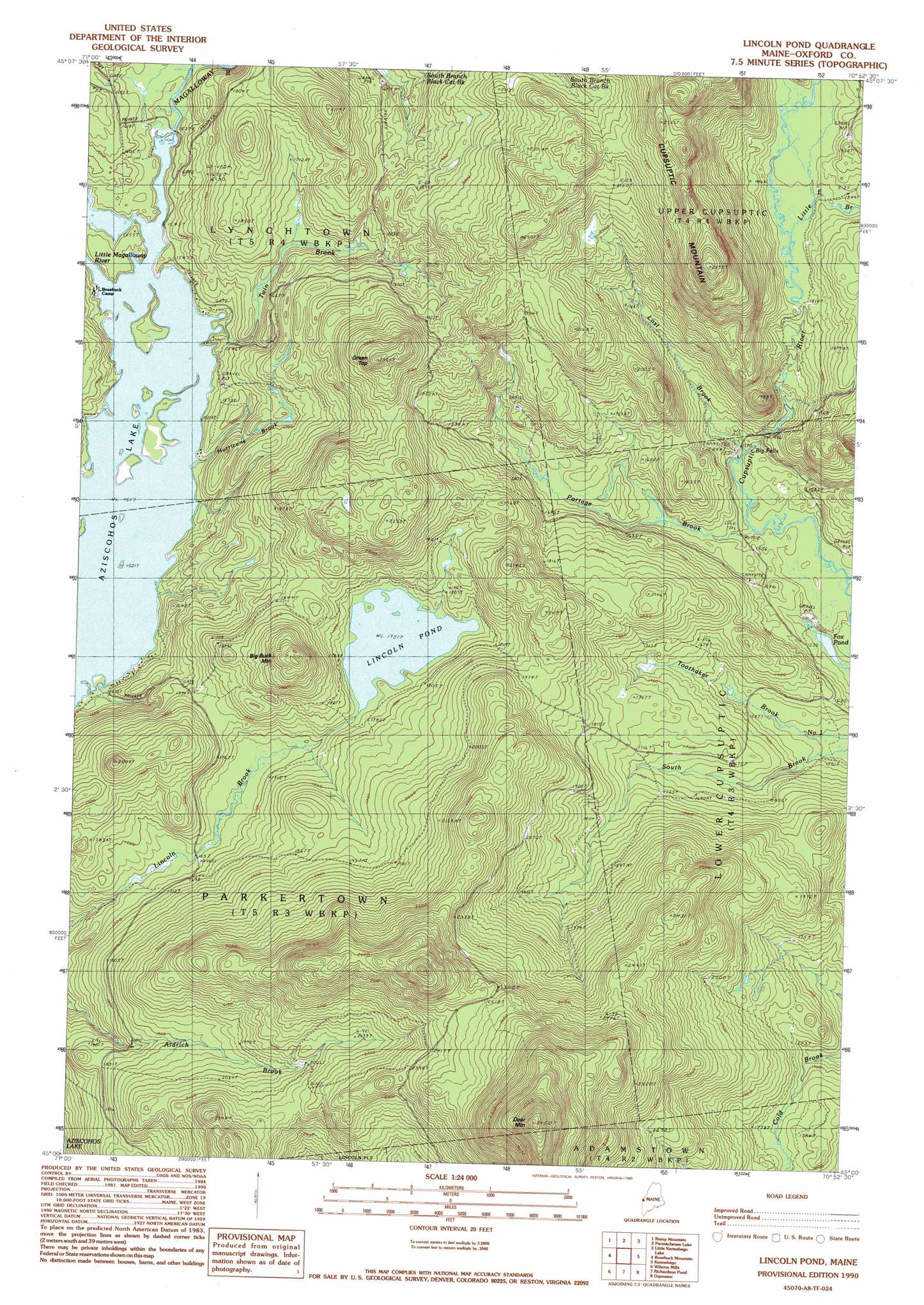
USGS Topo Quad 45070a8 - 1:24,000 scale
| Topo Map Name: | Lincoln Pond |
| USGS Topo Quad ID: | 45070a8 |
| Print Size: | ca. 21 1/4" wide x 27" high |
| Southeast Coordinates: | 45° N latitude / 70.875° W longitude |
| Map Center Coordinates: | 45.0625° N latitude / 70.9375° W longitude |
| U.S. State: | ME |
| Filename: | o45070a8.jpg |
| Download Map JPG Image: | Lincoln Pond topo map 1:24,000 scale |
| Map Type: | Topographic |
| Topo Series: | 7.5´ |
| Map Scale: | 1:24,000 |
| Source of Map Images: | United States Geological Survey (USGS) |
| Alternate Map Versions: |
Lincoln Pond ME 1977, updated 1983 Download PDF Buy paper map Lincoln Pond ME 1990, updated 1990 Download PDF Buy paper map Lincoln Pond ME 1990, updated 1990 Download PDF Buy paper map Lincoln Pond ME 2011 Download PDF Buy paper map Lincoln Pond ME 2014 Download PDF Buy paper map |
1:24,000 Topo Quads surrounding Lincoln Pond
Chartierville |
Moose Bog |
Twin Peaks |
Northwest Pond |
Chain Of Ponds |
Second Connecticut Lake |
Rump Mountain |
Parmachenee Lake |
Little Kennebago Lake |
Black Mountain |
Magalloway Mountain |
Bosebuck Mountain |
Lincoln Pond |
Kennebago |
Kennebago Lake |
Mount Pisgah |
Wilsons Mills |
Richardson Pond |
Oquossoc |
Rangeley |
Errol |
Umbagog Lake North |
Middle Dam |
Metallak Mountain |
Houghton |
> Back to 45070a1 at 1:100,000 scale
> Back to 45070a1 at 1:250,000 scale
> Back to U.S. Topo Maps home
Lincoln Pond topo map: Gazetteer
Lincoln Pond: Falls
Big Falls elevation 463m 1519′Lincoln Pond: Lakes
Fox Pond elevation 463m 1519′Lincoln Pond elevation 534m 1751′
Sunday Pond (historical) elevation 462m 1515′
Lincoln Pond: Streams
Hammel Brook elevation 463m 1519′Hurricane Brook elevation 462m 1515′
Little East Branch Cupsuptic River elevation 552m 1811′
Little Magalloway River elevation 463m 1519′
Lost Brook elevation 464m 1522′
Portage Brook elevation 462m 1515′
Twin Brook elevation 463m 1519′
Lincoln Pond: Summits
Big Buck Mountain elevation 671m 2201′Cupsuptic Mountain elevation 738m 2421′
Deer Mountain elevation 1050m 3444′
Green Top elevation 710m 2329′
Lincoln Pond digital topo map on disk
Buy this Lincoln Pond topo map showing relief, roads, GPS coordinates and other geographical features, as a high-resolution digital map file on DVD:
Maine, New Hampshire, Rhode Island & Eastern Massachusetts
Buy digital topo maps: Maine, New Hampshire, Rhode Island & Eastern Massachusetts