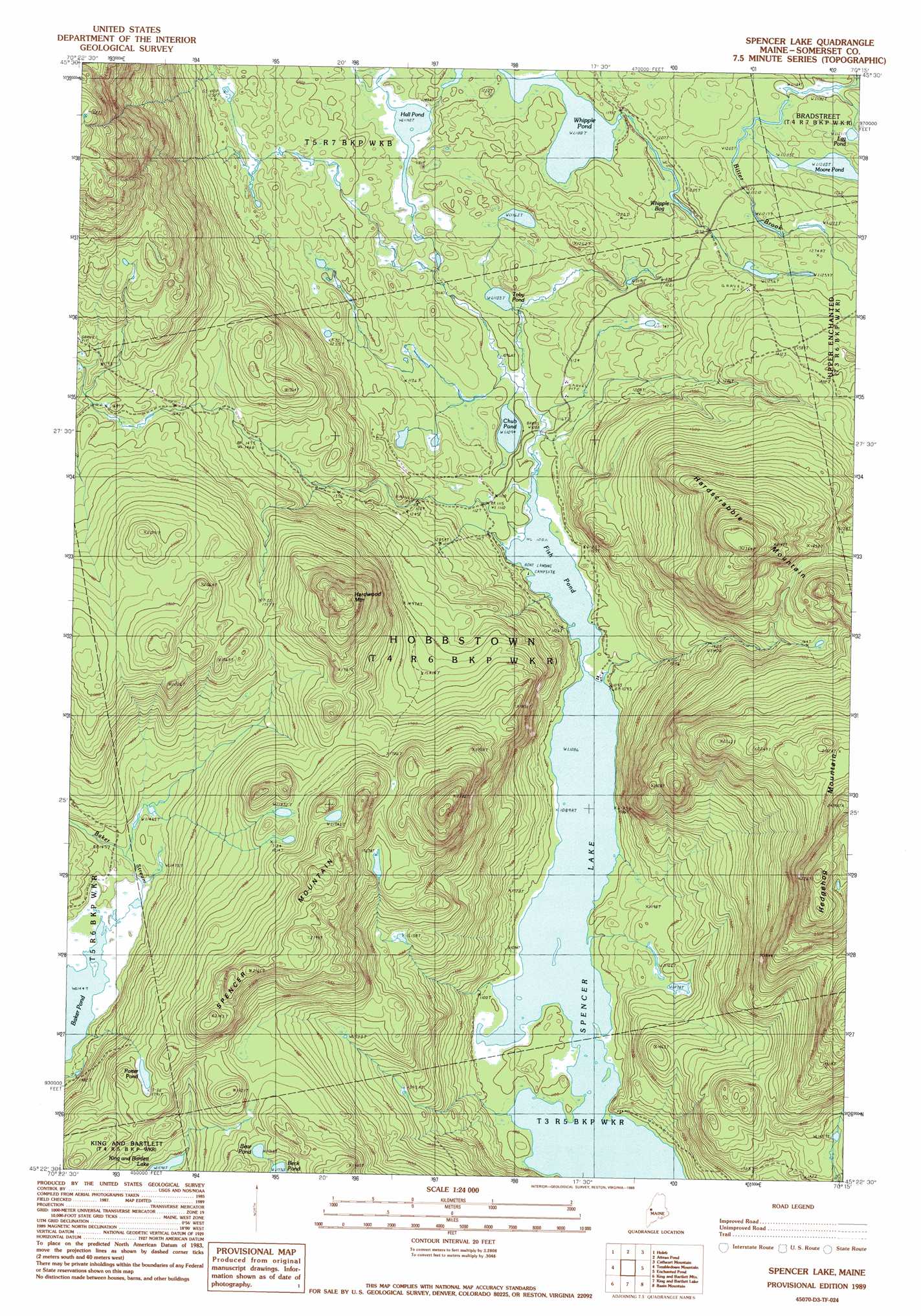
Spencer Lake Topo Map Maine
To zoom in, hover over the map of Spencer Lake
USGS Topo Quad 45070d3 - 1:24,000 scale
| Topo Map Name: | Spencer Lake |
| USGS Topo Quad ID: | 45070d3 |
| Print Size: | ca. 21 1/4" wide x 27" high |
| Southeast Coordinates: | 45.375° N latitude / 70.25° W longitude |
| Map Center Coordinates: | 45.4375° N latitude / 70.3125° W longitude |
| U.S. State: | ME |
| Filename: | o45070d3.jpg |
| Download Map JPG Image: | Spencer Lake topo map 1:24,000 scale |
| Map Type: | Topographic |
| Topo Series: | 7.5´ |
| Map Scale: | 1:24,000 |
| Source of Map Images: | United States Geological Survey (USGS) |
| Alternate Map Versions: |
Spencer Lake ME 1977, updated 1983 Download PDF Buy paper map Spencer Lake ME 1989, updated 1989 Download PDF Buy paper map Spencer Lake ME 2011 Download PDF Buy paper map Spencer Lake ME 2014 Download PDF Buy paper map |
1:24,000 Topo Quads surrounding Spencer Lake
Skinner Ne |
Stony Brook |
Jackman |
Heald Pond |
Churchill Stream |
Skinner |
Holeb |
Attean Pond |
Catheart Mountain |
Long Pond |
Kibby Mountain |
Tumbledown Mountain |
Spencer Lake |
Enchanted Pond |
Johnson Mountain |
Jim Pond |
King And Bartlett Mountain |
King And Bartlett Lake |
Basin Mountain |
Pierce Pond |
Tim Mountain |
Stratton |
The Horns |
Little Bigelow Mountain |
East Carry Pond |
> Back to 45070a1 at 1:100,000 scale
> Back to 45070a1 at 1:250,000 scale
> Back to U.S. Topo Maps home
Spencer Lake topo map: Gazetteer
Spencer Lake: Lakes
Baker Pond elevation 441m 1446′Bear Pond elevation 541m 1774′
Chub Pond elevation 333m 1092′
Egg Pond elevation 372m 1220′
Fish Pond elevation 331m 1085′
Hall Pond elevation 350m 1148′
Moore Pond elevation 367m 1204′
Porter Pond elevation 545m 1788′
Spencer Lake elevation 331m 1085′
Toby Pond elevation 336m 1102′
Whipple Pond elevation 362m 1187′
Spencer Lake: Summits
Hardscrabble Mountain elevation 713m 2339′Hardwood Mountain elevation 700m 2296′
Spencer Mountain elevation 728m 2388′
Spencer Lake: Swamps
Whipple Bog elevation 371m 1217′Spencer Lake digital topo map on disk
Buy this Spencer Lake topo map showing relief, roads, GPS coordinates and other geographical features, as a high-resolution digital map file on DVD:
Maine, New Hampshire, Rhode Island & Eastern Massachusetts
Buy digital topo maps: Maine, New Hampshire, Rhode Island & Eastern Massachusetts