Attean Pond Topo Map Maine
To zoom in, hover over the map of Attean Pond
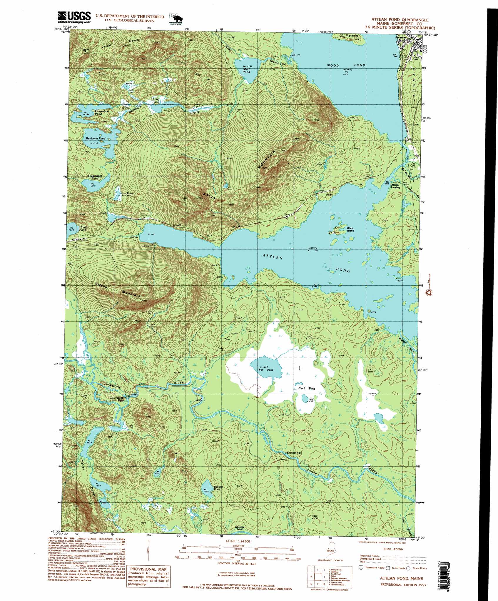
USGS Topo Quad 45070e3 - 1:24,000 scale
| Topo Map Name: | Attean Pond |
| USGS Topo Quad ID: | 45070e3 |
| Print Size: | ca. 21 1/4" wide x 27" high |
| Southeast Coordinates: | 45.5° N latitude / 70.25° W longitude |
| Map Center Coordinates: | 45.5625° N latitude / 70.3125° W longitude |
| U.S. State: | ME |
| Filename: | o45070e3.jpg |
| Download Map JPG Image: | Attean Pond topo map 1:24,000 scale |
| Map Type: | Topographic |
| Topo Series: | 7.5´ |
| Map Scale: | 1:24,000 |
| Source of Map Images: | United States Geological Survey (USGS) |
| Alternate Map Versions: |
Attean Pond ME 1977, updated 1983 Download PDF Buy paper map Attean Pond ME 1989, updated 1989 Download PDF Buy paper map Attean Pond ME 1989, updated 1989 Download PDF Buy paper map Attean Pond ME 1997, updated 1999 Download PDF Buy paper map Attean Pond ME 2011 Download PDF Buy paper map Attean Pond ME 2014 Download PDF Buy paper map |
1:24,000 Topo Quads surrounding Attean Pond
Sandy Bay Mountain |
Campbell Brook |
Boundary Bald Mountain |
Canada Falls Lake |
|
Skinner Ne |
Stony Brook |
Jackman |
Heald Pond |
Churchill Stream |
Skinner |
Holeb |
Attean Pond |
Catheart Mountain |
Long Pond |
Kibby Mountain |
Tumbledown Mountain |
Spencer Lake |
Enchanted Pond |
Johnson Mountain |
Jim Pond |
King And Bartlett Mountain |
King And Bartlett Lake |
Basin Mountain |
Pierce Pond |
> Back to 45070e1 at 1:100,000 scale
> Back to 45070a1 at 1:250,000 scale
> Back to U.S. Topo Maps home
Attean Pond topo map: Gazetteer
Attean Pond: Falls
Holeb Falls elevation 371m 1217′Attean Pond: Islands
Birch Island elevation 360m 1181′Attean Pond: Lakes
Attean Pond elevation 353m 1158′Benjamin Pond elevation 382m 1253′
Bog Pond elevation 361m 1184′
Boulder Pond elevation 363m 1190′
Clearwater Pond elevation 384m 1259′
Horseshoe Pond elevation 384m 1259′
Long Pond elevation 377m 1236′
Lost Pond elevation 391m 1282′
Mud Pond elevation 357m 1171′
Tobey Ponds elevation 372m 1220′
Wood Pond elevation 353m 1158′
Attean Pond: Populated Places
Attean (historical) elevation 370m 1213′Attean Landing elevation 364m 1194′
Jackman elevation 367m 1204′
Attean Pond: Rapids
Spencer Rips elevation 358m 1174′Attean Pond: Streams
Benjamin Brook elevation 361m 1184′Bitter Brook elevation 359m 1177′
McKenney Brook elevation 353m 1158′
Thompson Brook elevation 353m 1158′
Williams Brook elevation 353m 1158′
Wood Stream elevation 354m 1161′
Attean Pond: Summits
Attean Mountain elevation 727m 2385′Sally Mountain elevation 655m 2148′
Attean Pond: Swamps
Number Five Bog elevation 363m 1190′Attean Pond digital topo map on disk
Buy this Attean Pond topo map showing relief, roads, GPS coordinates and other geographical features, as a high-resolution digital map file on DVD:
Maine, New Hampshire, Rhode Island & Eastern Massachusetts
Buy digital topo maps: Maine, New Hampshire, Rhode Island & Eastern Massachusetts