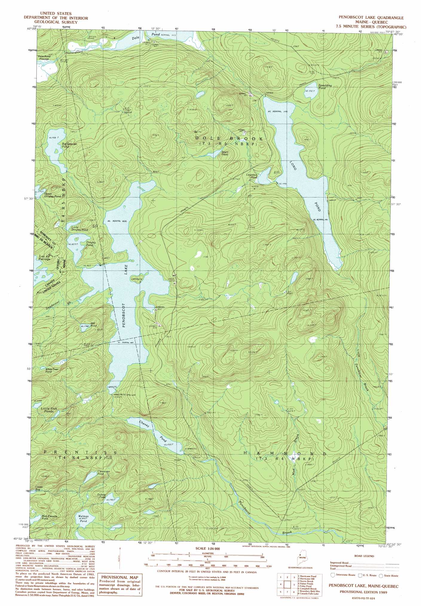
Penobscot Lake Topo Map Maine
To zoom in, hover over the map of Penobscot Lake
USGS Topo Quad 45070h2 - 1:24,000 scale
| Topo Map Name: | Penobscot Lake |
| USGS Topo Quad ID: | 45070h2 |
| Print Size: | ca. 21 1/4" wide x 27" high |
| Southeast Coordinates: | 45.875° N latitude / 70.125° W longitude |
| Map Center Coordinates: | 45.9375° N latitude / 70.1875° W longitude |
| U.S. State: | ME |
| Filename: | o45070h2.jpg |
| Download Map JPG Image: | Penobscot Lake topo map 1:24,000 scale |
| Map Type: | Topographic |
| Topo Series: | 7.5´ |
| Map Scale: | 1:24,000 |
| Source of Map Images: | United States Geological Survey (USGS) |
| Alternate Map Versions: |
Penobscot Lake ME 1977, updated 1983 Download PDF Buy paper map Penobscot Lake ME 1989, updated 1989 Download PDF Buy paper map Penobscot Lake ME 2011 Download PDF Buy paper map Penobscot Lake ME 2014 Download PDF Buy paper map |
1:24,000 Topo Quads surrounding Penobscot Lake
Saint Zacharie North |
Black Brook |
Hinckley Hill |
Saint John Pond Depot |
|
Saint Zacharie South |
Hurricane Hill |
Norris Brook |
Saint John Ponds |
|
Lac Portage |
Penobscot Lake |
Foley Pond |
Seboomook Lake West |
|
Sandy Bay Mountain |
Campbell Brook |
Boundary Bald Mountain |
Canada Falls Lake |
Tomhegan Pond |
Stony Brook |
Jackman |
Heald Pond |
Churchill Stream |
Brassua Lake West |
> Back to 45070e1 at 1:100,000 scale
> Back to 45070a1 at 1:250,000 scale
> Back to U.S. Topo Maps home
Penobscot Lake topo map: Gazetteer
Penobscot Lake: Dams
Long Pond Dam elevation 451m 1479′Penobscot Lake Dam elevation 488m 1601′
Penobscot Lake: Lakes
Big Grenier Pond elevation 512m 1679′Clearwater Pond elevation 589m 1932′
Dingley Pond elevation 496m 1627′
Dubois Pond elevation 536m 1758′
Hill Pond elevation 545m 1788′
Lewiston Pond elevation 453m 1486′
Little Dingley Pond elevation 499m 1637′
Little Fish Ponds elevation 629m 2063′
Lizzies Bog elevation 613m 2011′
Mary Petuche Pond elevation 549m 1801′
Sears Pond elevation 490m 1607′
Spaulding Pond elevation 461m 1512′
Upper Dingley Pond elevation 542m 1778′
Welman Pond elevation 506m 1660′
White Deer Pond elevation 552m 1811′
Penobscot Lake: Reservoirs
Cheney Pond elevation 464m 1522′Long Pond elevation 451m 1479′
Penobscot Lake elevation 488m 1601′
Penobscot Lake: Streams
Deadwater Brook elevation 488m 1601′Mud Brook elevation 398m 1305′
Penobscot Lake digital topo map on disk
Buy this Penobscot Lake topo map showing relief, roads, GPS coordinates and other geographical features, as a high-resolution digital map file on DVD:
Maine, New Hampshire, Rhode Island & Eastern Massachusetts
Buy digital topo maps: Maine, New Hampshire, Rhode Island & Eastern Massachusetts