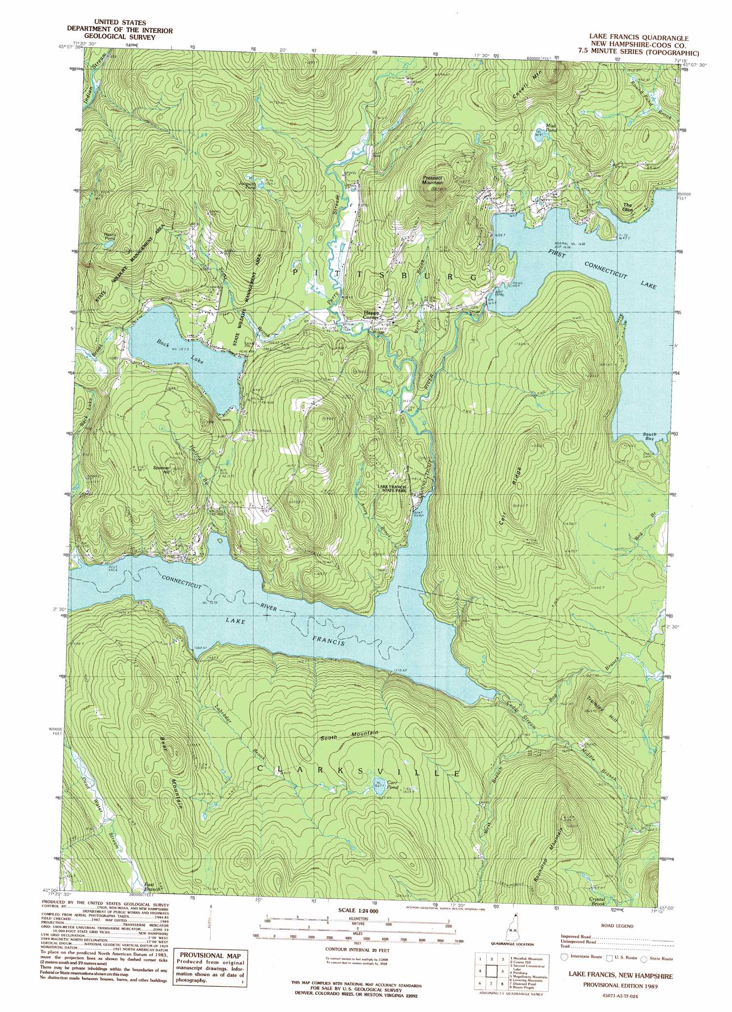
Lake Francis Topo Map New Hampshire
To zoom in, hover over the map of Lake Francis
USGS Topo Quad 45071a3 - 1:24,000 scale
| Topo Map Name: | Lake Francis |
| USGS Topo Quad ID: | 45071a3 |
| Print Size: | ca. 21 1/4" wide x 27" high |
| Southeast Coordinates: | 45° N latitude / 71.25° W longitude |
| Map Center Coordinates: | 45.0625° N latitude / 71.3125° W longitude |
| U.S. State: | NH |
| Filename: | o45071a3.jpg |
| Download Map JPG Image: | Lake Francis topo map 1:24,000 scale |
| Map Type: | Topographic |
| Topo Series: | 7.5´ |
| Map Scale: | 1:24,000 |
| Source of Map Images: | United States Geological Survey (USGS) |
| Alternate Map Versions: |
Lake Francis NH 1989, updated 1989 Download PDF Buy paper map Lake Francis NH 2012 Download PDF Buy paper map Lake Francis NH 2015 Download PDF Buy paper map |
1:24,000 Topo Quads surrounding Lake Francis
Bellefeuille |
Chartierville |
Moose Bog |
||
Malvina |
Cowen Hill |
Second Connecticut Lake |
Rump Mountain |
|
Pittsburg |
Lake Francis |
Magalloway Mountain |
Bosebuck Mountain |
|
Monadnock Mountain |
Lovering Mountain |
Diamond Pond |
Mount Pisgah |
Wilsons Mills |
Tinkerville |
Blue Mountain |
Dixville Notch |
Errol |
Umbagog Lake North |
> Back to 45071a1 at 1:100,000 scale
> Back to 45070a1 at 1:250,000 scale
> Back to U.S. Topo Maps home
Lake Francis topo map: Gazetteer
Lake Francis: Bays
South Bay elevation 499m 1637′Lake Francis: Bridges
Happy Corner Bridge elevation 464m 1522′River Road Bridge elevation 442m 1450′
Lake Francis: Dams
Back Lake Dam elevation 485m 1591′First Connecticut Lake Dam elevation 499m 1637′
Lake Francis: Lakes
Back Lake elevation 480m 1574′Carr Pond elevation 561m 1840′
Harris Pond elevation 584m 1916′
Jacquith Pond elevation 529m 1735′
Mud Pond elevation 551m 1807′
Lake Francis: Parks
Brown Company Lots State Wildlife Management Area elevation 525m 1722′Gray Lot State Wildlife Management Area elevation 586m 1922′
Lake Francis State Park elevation 437m 1433′
Lake Francis Wildlife Area elevation 497m 1630′
Lake Francis: Populated Places
Happy Corner elevation 473m 1551′The Glen elevation 524m 1719′
Lake Francis: Reservoirs
Back Lake elevation 485m 1591′First Connecticut Lake elevation 499m 1637′
Lake Francis: Ridges
Bear Mountain elevation 555m 1820′Carr Ridge elevation 615m 2017′
Lake Francis: Streams
Amey Brook elevation 420m 1377′Bog Branch elevation 428m 1404′
Cedar Stream elevation 422m 1384′
Crystal Brook elevation 571m 1873′
East Branch Dead Water Stream elevation 481m 1578′
Hollow Brook elevation 420m 1377′
Labrador Brook elevation 419m 1374′
Middle Branch Cedar Stream elevation 437m 1433′
Perry Brook elevation 449m 1473′
Perry Stream elevation 443m 1453′
Roby Brook elevation 408m 1338′
Scott Brook elevation 469m 1538′
West Branch Cedar Stream elevation 438m 1437′
Lake Francis: Summits
Covell Mountain elevation 722m 2368′Prospect Mountain elevation 670m 2198′
Roundtop Mountain elevation 654m 2145′
South Mountain elevation 544m 1784′
Spooner Hill elevation 546m 1791′
Tromley Hill elevation 549m 1801′
Lake Francis digital topo map on disk
Buy this Lake Francis topo map showing relief, roads, GPS coordinates and other geographical features, as a high-resolution digital map file on DVD:
Maine, New Hampshire, Rhode Island & Eastern Massachusetts
Buy digital topo maps: Maine, New Hampshire, Rhode Island & Eastern Massachusetts