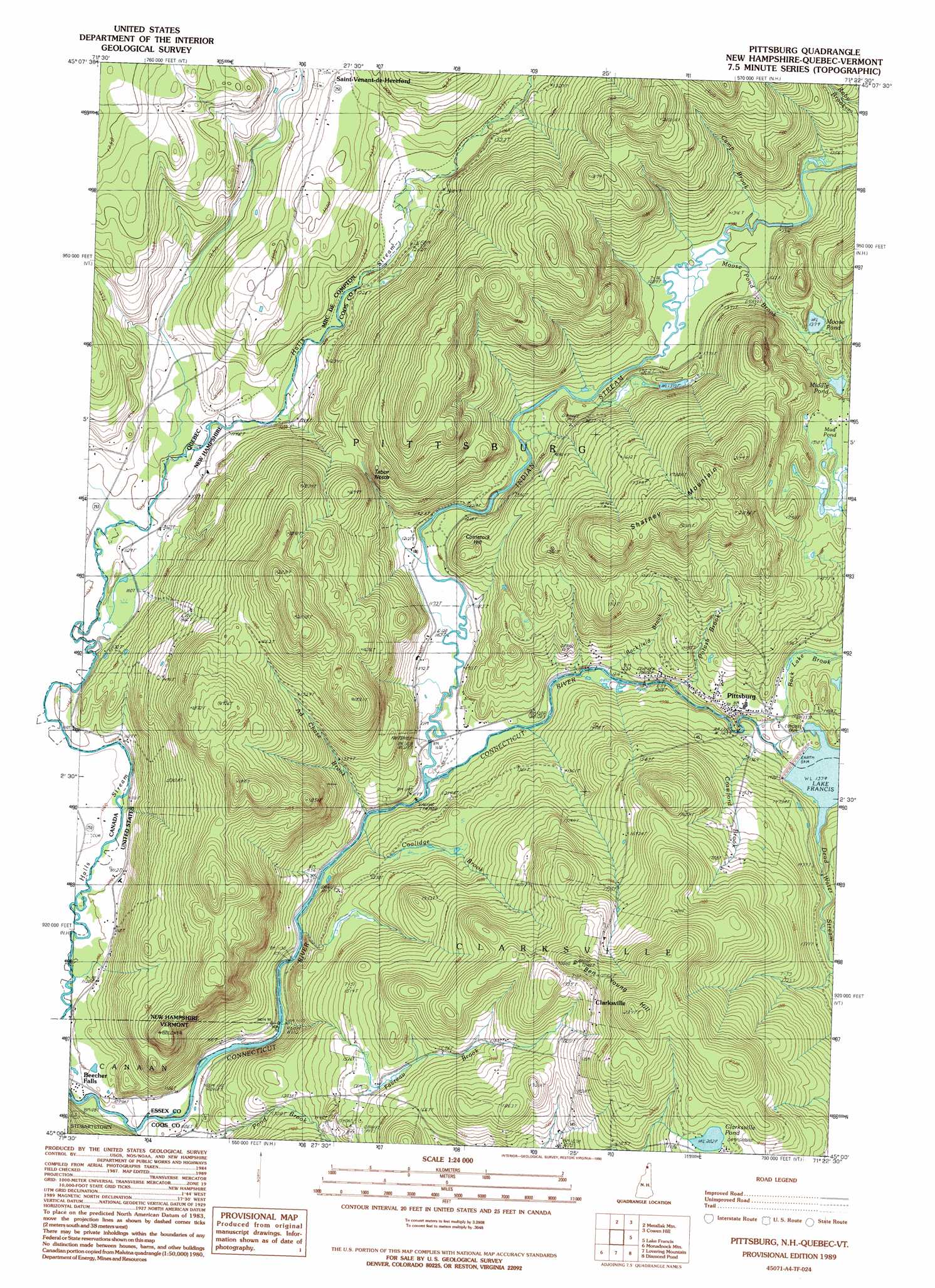
Pittsburg Topo Map New Hampshire
To zoom in, hover over the map of Pittsburg
USGS Topo Quad 45071a4 - 1:24,000 scale
| Topo Map Name: | Pittsburg |
| USGS Topo Quad ID: | 45071a4 |
| Print Size: | ca. 21 1/4" wide x 27" high |
| Southeast Coordinates: | 45° N latitude / 71.375° W longitude |
| Map Center Coordinates: | 45.0625° N latitude / 71.4375° W longitude |
| U.S. States: | NH, VT |
| Filename: | o45071a4.jpg |
| Download Map JPG Image: | Pittsburg topo map 1:24,000 scale |
| Map Type: | Topographic |
| Topo Series: | 7.5´ |
| Map Scale: | 1:24,000 |
| Source of Map Images: | United States Geological Survey (USGS) |
| Alternate Map Versions: |
Pittsburg NH 1989, updated 1989 Download PDF Buy paper map Pittsburg NH 1989, updated 1990 Download PDF Buy paper map Pittsburg NH 1989, updated 1990 Download PDF Buy paper map Pittsburg NH 2012 Download PDF Buy paper map Pittsburg NH 2015 Download PDF Buy paper map |
1:24,000 Topo Quads surrounding Pittsburg
Bellefeuille |
Chartierville |
|||
Malvina |
Cowen Hill |
Second Connecticut Lake |
||
Pittsburg |
Lake Francis |
Magalloway Mountain |
||
Averill Lake |
Monadnock Mountain |
Lovering Mountain |
Diamond Pond |
Mount Pisgah |
Bloomfield |
Tinkerville |
Blue Mountain |
Dixville Notch |
Errol |
> Back to 45071a1 at 1:100,000 scale
> Back to 45070a1 at 1:250,000 scale
> Back to U.S. Topo Maps home
Pittsburg topo map: Gazetteer
Pittsburg: Bridges
Pittsburg-Clarksville Bridge elevation 367m 1204′Pittsburg: Dams
Kim Day Dam (historical) elevation 389m 1276′Murphy Dam elevation 420m 1377′
Pittsburg: Gaps
Tabor Notch elevation 434m 1423′Pittsburg: Lakes
Clarksville Pond elevation 617m 2024′Middle Pond elevation 459m 1505′
Moose Pond elevation 426m 1397′
Mud Pond elevation 461m 1512′
Pittsburg: Populated Places
Pittsburg elevation 402m 1318′Pittsburg: Post Offices
Pittsburg Post Office elevation 405m 1328′Pittsburg: Reservoirs
Lake Francis elevation 402m 1318′Pittsburg: Ridges
Shatney Mountain elevation 637m 2089′Pittsburg: Streams
Ad Chase Brook elevation 352m 1154′Back Lake Brook elevation 396m 1299′
Backfield Brook elevation 362m 1187′
Bishop Brook elevation 329m 1079′
Camp Brook elevation 397m 1302′
Coolidge Brook elevation 355m 1164′
Crawford Brook elevation 394m 1292′
Dead Water Stream elevation 420m 1377′
Favreau Brook elevation 350m 1148′
Indian Stream elevation 352m 1154′
Moose Pond Brook elevation 393m 1289′
Potash Brook elevation 376m 1233′
Pittsburg: Summits
Ben Young Hill elevation 632m 2073′Comstock Hill elevation 431m 1414′
Pittsburg digital topo map on disk
Buy this Pittsburg topo map showing relief, roads, GPS coordinates and other geographical features, as a high-resolution digital map file on DVD:
Maine, New Hampshire, Rhode Island & Eastern Massachusetts
Buy digital topo maps: Maine, New Hampshire, Rhode Island & Eastern Massachusetts