Polaski Topo Map Michigan
To zoom in, hover over the map of Polaski
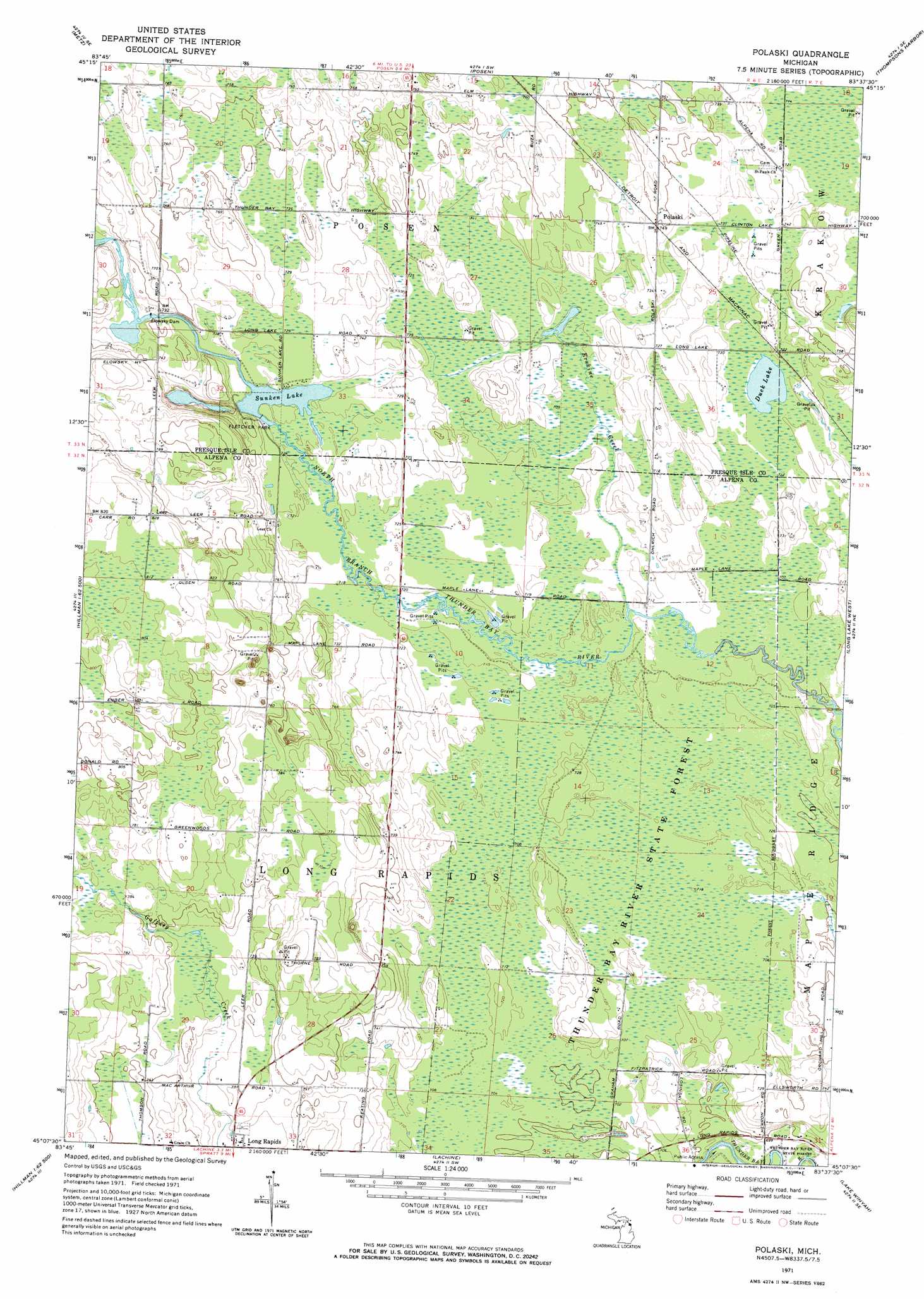
USGS Topo Quad 45083b6 - 1:24,000 scale
| Topo Map Name: | Polaski |
| USGS Topo Quad ID: | 45083b6 |
| Print Size: | ca. 21 1/4" wide x 27" high |
| Southeast Coordinates: | 45.125° N latitude / 83.625° W longitude |
| Map Center Coordinates: | 45.1875° N latitude / 83.6875° W longitude |
| U.S. State: | MI |
| Filename: | o45083b6.jpg |
| Download Map JPG Image: | Polaski topo map 1:24,000 scale |
| Map Type: | Topographic |
| Topo Series: | 7.5´ |
| Map Scale: | 1:24,000 |
| Source of Map Images: | United States Geological Survey (USGS) |
| Alternate Map Versions: |
Polaski MI 1971, updated 1974 Download PDF Buy paper map Polaski MI 2011 Download PDF Buy paper map Polaski MI 2014 Download PDF Buy paper map Polaski MI 2016 Download PDF Buy paper map |
1:24,000 Topo Quads surrounding Polaski
Moltke |
Rogers City |
Adams Point |
||
Hawks |
Metz |
Posen |
Thompsons Harbor |
Presque Isle |
Royston |
Hillman Ne |
Polaski |
Long Lake West |
Long Lake East |
Hillman |
Jewett Creek |
Lachine |
Lake Winyah |
Alpena |
Rust |
Beaver Lake |
Evans Creek |
Big Ravine Creek |
Ossineke |
> Back to 45083a1 at 1:100,000 scale
> Back to 45082a1 at 1:250,000 scale
> Back to U.S. Topo Maps home
Polaski topo map: Gazetteer
Polaski: Dams
Elowsky Dam elevation 218m 715′Polaski: Lakes
Duck Lake elevation 217m 711′Sunken Lake elevation 218m 715′
Polaski: Parks
Elowsky Mill Historical Marker elevation 219m 718′Fletcher Park elevation 231m 757′
Sunken Lake Park elevation 220m 721′
Polaski: Populated Places
Leer elevation 250m 820′Long Rapids elevation 219m 718′
Polaski elevation 228m 748′
Polaski: Post Offices
Leer Post Office (historical) elevation 250m 820′Long Rapids Post Office (historical) elevation 219m 718′
Orchard Hill Post Office (historical) elevation 212m 695′
Sobieski Post Office (historical) elevation 228m 748′
Polaski: Streams
Erskine Creek elevation 215m 705′Polaski digital topo map on disk
Buy this Polaski topo map showing relief, roads, GPS coordinates and other geographical features, as a high-resolution digital map file on DVD:
 map DVD")