Rogers City Topo Map Michigan
To zoom in, hover over the map of Rogers City
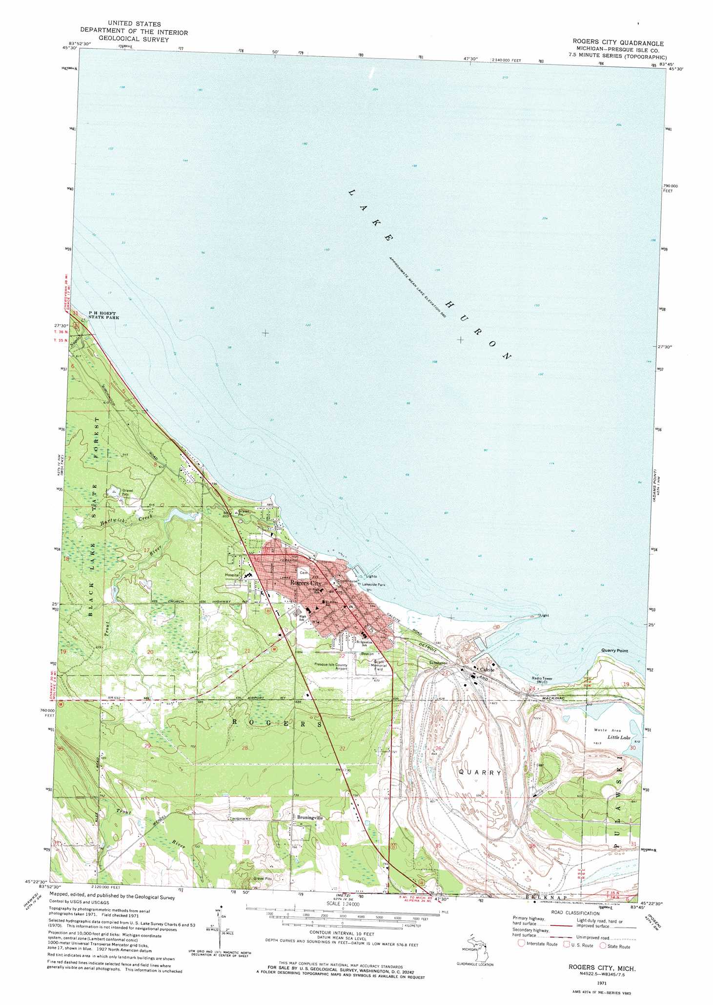
USGS Topo Quad 45083d7 - 1:24,000 scale
| Topo Map Name: | Rogers City |
| USGS Topo Quad ID: | 45083d7 |
| Print Size: | ca. 21 1/4" wide x 27" high |
| Southeast Coordinates: | 45.375° N latitude / 83.75° W longitude |
| Map Center Coordinates: | 45.4375° N latitude / 83.8125° W longitude |
| U.S. State: | MI |
| Filename: | o45083d7.jpg |
| Download Map JPG Image: | Rogers City topo map 1:24,000 scale |
| Map Type: | Topographic |
| Topo Series: | 7.5´ |
| Map Scale: | 1:24,000 |
| Source of Map Images: | United States Geological Survey (USGS) |
| Alternate Map Versions: |
Rogers City MI 1971, updated 1974 Download PDF Buy paper map Rogers City MI 2011 Download PDF Buy paper map Rogers City MI 2014 Download PDF Buy paper map Rogers City MI 2016 Download PDF Buy paper map |
1:24,000 Topo Quads surrounding Rogers City
Ocqueoc |
Moltke |
Rogers City |
Adams Point |
|
Millersburg |
Hawks |
Metz |
Posen |
Thompsons Harbor |
Cranberry Lake |
Royston |
Hillman Ne |
Polaski |
Long Lake West |
> Back to 45083a1 at 1:100,000 scale
> Back to 45082a1 at 1:250,000 scale
> Back to U.S. Topo Maps home
Rogers City topo map: Gazetteer
Rogers City: Airports
Presque Isle County Airport elevation 202m 662′Rogers City: Capes
Quarry Point elevation 178m 583′Rogers City: Harbors
Rogers City Yacht Harbor elevation 176m 577′Rogers City: Lakes
Little Lake elevation 186m 610′Rogers City: Parks
Gulpin Memorial Field elevation 200m 656′Lakeside Park elevation 178m 583′
North Shore Park elevation 177m 580′
Riverview Park elevation 178m 583′
Seagull Point Park elevation 177m 580′
South Shore Park elevation 177m 580′
Trout River Park elevation 182m 597′
World's Largest Limestone Quarry Historical Marker elevation 179m 587′
Rogers City: Populated Places
Bruningville elevation 238m 780′Calcite elevation 182m 597′
Presque Isle Estates elevation 198m 649′
Rogers City elevation 182m 597′
Rogers City: Post Offices
Quarry Post Office (historical) elevation 189m 620′Rogers City Post Office elevation 185m 606′
Rogers City: Streams
Hartwick Creek elevation 187m 613′Nagels Creek elevation 176m 577′
Trout River elevation 176m 577′
Rogers City digital topo map on disk
Buy this Rogers City topo map showing relief, roads, GPS coordinates and other geographical features, as a high-resolution digital map file on DVD:
 map DVD")