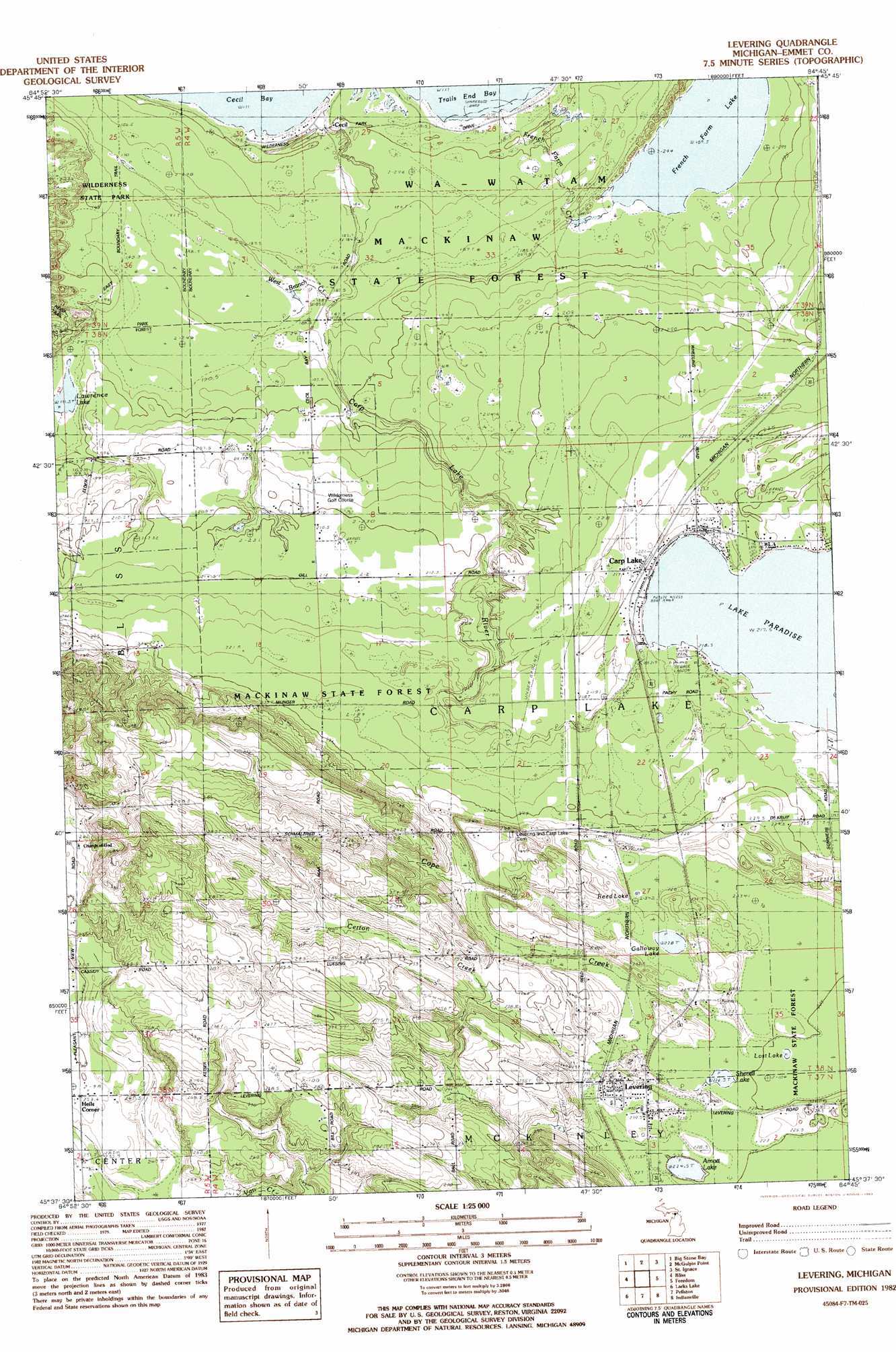
Levaring Topo Map Michigan
To zoom in, hover over the map of Levaring
USGS Topo Quad 45084f7 - 1:25,000 scale
| Topo Map Name: | Levaring |
| USGS Topo Quad ID: | 45084f7 |
| Print Size: | ca. 21 1/4" wide x 27" high |
| Southeast Coordinates: | 45.625° N latitude / 84.75° W longitude |
| Map Center Coordinates: | 45.6875° N latitude / 84.8125° W longitude |
| U.S. State: | MI |
| Filename: | l45084f7.jpg |
| Download Map JPG Image: | Levaring topo map 1:25,000 scale |
| Map Type: | Topographic |
| Topo Series: | 7.5´ |
| Map Scale: | 1:25,000 |
| Source of Map Images: | United States Geological Survey (USGS) |
| Alternate Map Versions: |
Levering MI 1982, updated 1983 Download PDF Buy paper map |
1:24,000 Topo Quads surrounding Levaring
Pnte Aux Chenes |
Moran |
Evergreen Shores |
Saint Martin Island |
|
Waugoshance Island |
Big Stone Bay |
Mcgulpin Point |
Saint Ignace |
Round Island |
Cross Village |
Bliss |
Levaring |
Freedom |
Point Nipigon |
Goodhart |
Larks Lake |
Pellston |
Indian Village |
Mullett Lake |
Forest Beach |
Harbor Springs |
Alanson |
Burt Lake |
Indian River |
> Back to 45084e1 at 1:100,000 scale
> Back to 45084a1 at 1:250,000 scale
> Back to U.S. Topo Maps home
Levaring topo map: Gazetteer
Levaring: Bays
Cecil Bay elevation 177m 580′Levaring: Lakes
Alke Paradise elevation 217m 711′Arnott Lake elevation 224m 734′
French Farm Lake elevation 189m 620′
Galloway Lake elevation 233m 764′
Lake Paradise elevation 217m 711′
Lawrence Lake elevation 191m 626′
Lost Lake elevation 224m 734′
Reed Lake elevation 228m 748′
Sherett Lake elevation 226m 741′
Levaring: Populated Places
Carp Lake elevation 222m 728′Cecil elevation 180m 590′
Levering elevation 233m 764′
Levaring: Post Offices
Carp Lake Post Office elevation 219m 718′Cecil Post Office (historical) elevation 180m 590′
Levering Post Office elevation 234m 767′
Levaring: Streams
Carp Lake River elevation 177m 580′Certon Creek elevation 230m 754′
Cope Creek elevation 232m 761′
French Farm Creek elevation 177m 580′
Levaring: Summits
Mountain Nebo elevation 201m 659′Levaring digital topo map on disk
Buy this Levaring topo map showing relief, roads, GPS coordinates and other geographical features, as a high-resolution digital map file on DVD: