Pnte Aux Chenes Topo Map Michigan
To zoom in, hover over the map of Pnte Aux Chenes
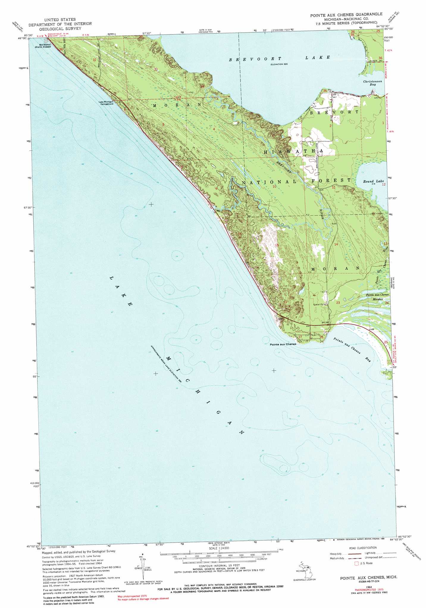
USGS Topo Quad 45084h8 - 1:24,000 scale
| Topo Map Name: | Pnte Aux Chenes |
| USGS Topo Quad ID: | 45084h8 |
| Print Size: | ca. 21 1/4" wide x 27" high |
| Southeast Coordinates: | 45.875° N latitude / 84.875° W longitude |
| Map Center Coordinates: | 45.9375° N latitude / 84.9375° W longitude |
| U.S. State: | MI |
| Filename: | o45084h8.jpg |
| Download Map JPG Image: | Pnte Aux Chenes topo map 1:24,000 scale |
| Map Type: | Topographic |
| Topo Series: | 7.5´ |
| Map Scale: | 1:24,000 |
| Source of Map Images: | United States Geological Survey (USGS) |
| Alternate Map Versions: |
Pointe Aux Chenex MI 1964, updated 1966 Download PDF Buy paper map Pointe Aux Chenes MI 1964, updated 1989 Download PDF Buy paper map Pointe aux Chenes MI 2011 Download PDF Buy paper map Pointe aux Chenes MI 2014 Download PDF Buy paper map Pointe aux Chenes MI 2017 Download PDF Buy paper map |
| FStopo: | US Forest Service topo Pointe aux Chenes is available: Download FStopo PDF Download FStopo TIF |
1:24,000 Topo Quads surrounding Pnte Aux Chenes
Rexton |
Trout Lake |
Ozark |
Ozark Ne |
Fibre |
Epoufette |
Brevort |
Kenneth |
Ozark Se |
Charles |
Pnte Aux Chenes |
Moran |
Evergreen Shores |
||
Waugoshance Island |
Big Stone Bay |
Mcgulpin Point |
Saint Ignace |
|
Cross Village |
Bliss |
Levaring |
Freedom |
> Back to 45084e1 at 1:100,000 scale
> Back to 45084a1 at 1:250,000 scale
> Back to U.S. Topo Maps home
Pnte Aux Chenes topo map: Gazetteer
Pnte Aux Chenes: Bays
Christensen Bay elevation 190m 623′Pointe aux Chenes Bay elevation 177m 580′
Pnte Aux Chenes: Capes
Pointe aux Chenes elevation 182m 597′Pnte Aux Chenes: Streams
Brevoort River elevation 178m 583′Pointe aux Chenes River elevation 177m 580′
Pnte Aux Chenes: Swamps
Pointe aux Chenes Marshes elevation 180m 590′Pnte Aux Chenes digital topo map on disk
Buy this Pnte Aux Chenes topo map showing relief, roads, GPS coordinates and other geographical features, as a high-resolution digital map file on DVD: