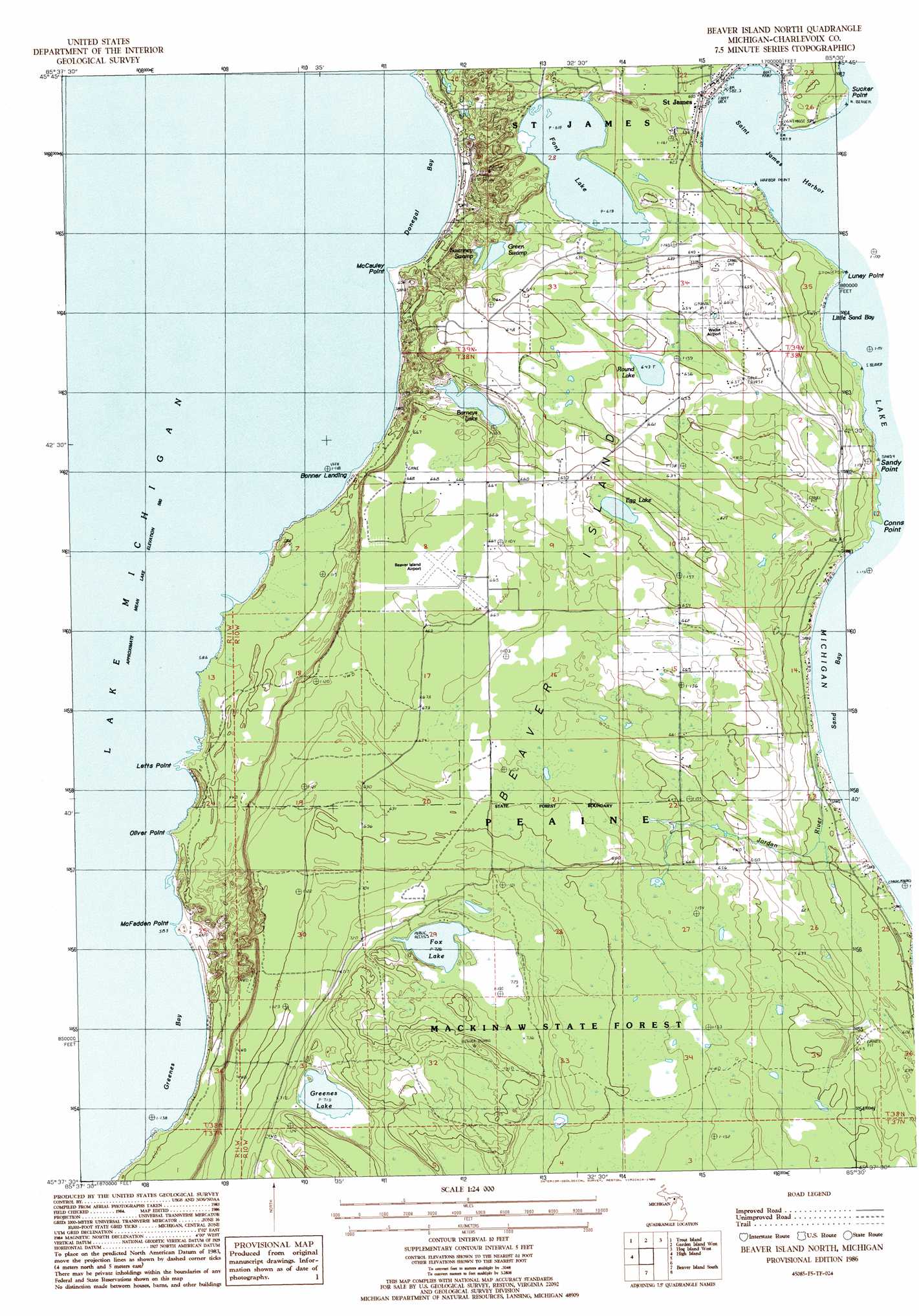
Beaver Island North Topo Map Michigan
To zoom in, hover over the map of Beaver Island North
USGS Topo Quad 45085f5 - 1:24,000 scale
| Topo Map Name: | Beaver Island North |
| USGS Topo Quad ID: | 45085f5 |
| Print Size: | ca. 21 1/4" wide x 27" high |
| Southeast Coordinates: | 45.625° N latitude / 85.5° W longitude |
| Map Center Coordinates: | 45.6875° N latitude / 85.5625° W longitude |
| U.S. State: | MI |
| Filename: | o45085f5.jpg |
| Download Map JPG Image: | Beaver Island North topo map 1:24,000 scale |
| Map Type: | Topographic |
| Topo Series: | 7.5´ |
| Map Scale: | 1:24,000 |
| Source of Map Images: | United States Geological Survey (USGS) |
| Alternate Map Versions: |
Beaver Island North MI 1986, updated 1986 Download PDF Buy paper map Beaver Island North MI 2011 Download PDF Buy paper map Beaver Island North MI 2014 Download PDF Buy paper map Beaver Island North MI 2016 Download PDF Buy paper map |
1:24,000 Topo Quads surrounding Beaver Island North
Hughes Point |
Point Patterson |
|||
Garden Island West |
Hog Island West |
Hog Island East |
||
Gull Island |
High Island |
Beaver Island North |
||
Beaver Island South |
||||
South Fox Island |
> Back to 45085e1 at 1:100,000 scale
> Back to 45084a1 at 1:250,000 scale
> Back to U.S. Topo Maps home
Beaver Island North topo map: Gazetteer
Beaver Island North: Airports
Beaver Island Airport elevation 203m 666′Welke Airport elevation 201m 659′
Beaver Island North: Bays
Donegal Bay elevation 176m 577′Greenes Bay elevation 176m 577′
Little Sand Bay elevation 176m 577′
Saint James Harbor elevation 176m 577′
Sand Bay elevation 176m 577′
Beaver Island North: Capes
Lefts Point elevation 178m 583′Luney Point elevation 178m 583′
McCauley Point elevation 179m 587′
McFadden Point elevation 182m 597′
Oliver Point elevation 179m 587′
Beaver Island North: Islands
Beaver Island elevation 212m 695′Beaver Island North: Lakes
Barneys Lake elevation 186m 610′Egg Lake elevation 196m 643′
Font Lake elevation 189m 620′
Fox Lake elevation 221m 725′
Greenes Lake elevation 219m 718′
Round Lake elevation 196m 643′
Beaver Island North: Parks
Mormon Print Shop Historical Marker elevation 179m 587′Beaver Island North: Populated Places
Bonner Landing elevation 179m 587′Beaver Island North: Streams
Jordan River elevation 180m 590′Beaver Island North: Swamps
Green Swamp elevation 186m 610′Swenney Swamp elevation 186m 610′
Beaver Island North digital topo map on disk
Buy this Beaver Island North topo map showing relief, roads, GPS coordinates and other geographical features, as a high-resolution digital map file on DVD: