Washington Island Nw Topo Map Wisconsin
To zoom in, hover over the map of Washington Island Nw
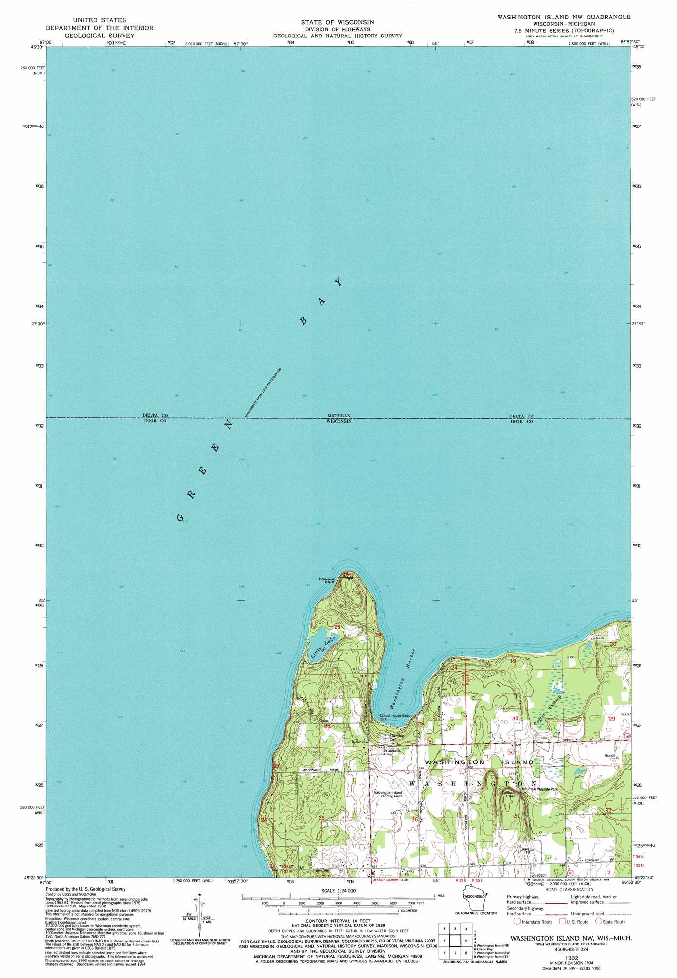
USGS Topo Quad 45086d8 - 1:24,000 scale
| Topo Map Name: | Washington Island Nw |
| USGS Topo Quad ID: | 45086d8 |
| Print Size: | ca. 21 1/4" wide x 27" high |
| Southeast Coordinates: | 45.375° N latitude / 86.875° W longitude |
| Map Center Coordinates: | 45.4375° N latitude / 86.9375° W longitude |
| U.S. States: | WI, MI |
| Filename: | o45086d8.jpg |
| Download Map JPG Image: | Washington Island Nw topo map 1:24,000 scale |
| Map Type: | Topographic |
| Topo Series: | 7.5´ |
| Map Scale: | 1:24,000 |
| Source of Map Images: | United States Geological Survey (USGS) |
| Alternate Map Versions: |
Washington Island NW WI 1982, updated 1982 Download PDF Buy paper map Washington Island NW WI 1982, updated 1994 Download PDF Buy paper map Washington Island NW WI 2011 Download PDF Buy paper map Washington Island NW WI 2013 Download PDF Buy paper map Washington Island NW WI 2016 Download PDF Buy paper map |
1:24,000 Topo Quads surrounding Washington Island Nw
Ford River |
Escanaba |
Peninsula Point |
Chippewa Point |
Fayette |
Henderson Lakes |
Fairport |
|||
Washington Island Nw |
Washington Island Nw |
|||
Ellison Bay |
Washington Island Sw |
Washington Island Se |
||
Ephraim |
Sister Bay |
Spider Island |
> Back to 45086a1 at 1:100,000 scale
> Back to 45086a1 at 1:250,000 scale
> Back to U.S. Topo Maps home
Washington Island Nw topo map: Gazetteer
Washington Island Nw: Airports
Washington Island Airport elevation 195m 639′Washington Island Nw: Bays
Washington Harbor elevation 177m 580′Washington Island Nw: Cliffs
Bowyer Bluff elevation 220m 721′Washington Island Nw: Islands
Washington Island elevation 215m 705′Washington Island Nw: Lakes
Little Lake elevation 178m 583′Washington Island Nw: Parks
Coffey Swamp State Natural Area elevation 182m 597′Mountain Wayside Park elevation 198m 649′
School House Beach Park elevation 181m 593′
Washington Island Nw: Populated Places
Washington elevation 206m 675′Washington Island Nw: Swamps
Coffee Swamp elevation 182m 597′Washington Island Nw digital topo map on disk
Buy this Washington Island Nw topo map showing relief, roads, GPS coordinates and other geographical features, as a high-resolution digital map file on DVD: