Marinette West Topo Map Wisconsin
To zoom in, hover over the map of Marinette West
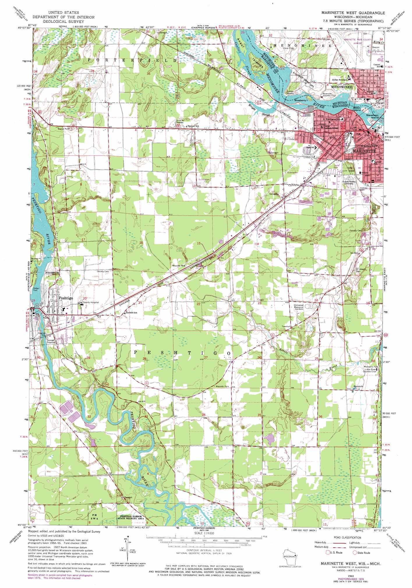
USGS Topo Quad 45087a6 - 1:24,000 scale
| Topo Map Name: | Marinette West |
| USGS Topo Quad ID: | 45087a6 |
| Print Size: | ca. 21 1/4" wide x 27" high |
| Southeast Coordinates: | 45° N latitude / 87.625° W longitude |
| Map Center Coordinates: | 45.0625° N latitude / 87.6875° W longitude |
| U.S. States: | WI, MI |
| Filename: | o45087a6.jpg |
| Download Map JPG Image: | Marinette West topo map 1:24,000 scale |
| Map Type: | Topographic |
| Topo Series: | 7.5´ |
| Map Scale: | 1:24,000 |
| Source of Map Images: | United States Geological Survey (USGS) |
| Alternate Map Versions: |
Marinette West WI 1963, updated 1964 Download PDF Buy paper map Marinette West WI 1963, updated 1977 Download PDF Buy paper map Marinette West WI 2011 Download PDF Buy paper map Marinette West WI 2013 Download PDF Buy paper map Marinette West WI 2016 Download PDF Buy paper map |
1:24,000 Topo Quads surrounding Marinette West
Wausaukee South |
Bear Point |
Mcallister |
Wallace |
Arthur Bay |
Loomis |
Porterfield |
Chappee Rapids |
Birch Creek |
Chambers Island Nw |
Porterfiled Sw |
Harmony |
Marinette West |
Marinette East |
Green Island |
Oconto West |
Oconto East |
Peshtigo Harbor |
Idlewild |
|
Pensaukee |
Oconto Se |
Little Sturgeon Sw |
Little Sturgeon |
Sturgeon Bay West |
> Back to 45087a1 at 1:100,000 scale
> Back to 45086a1 at 1:250,000 scale
> Back to U.S. Topo Maps home
Marinette West topo map: Gazetteer
Marinette West: Airports
Larson Airport elevation 187m 613′Marinette West: Channels
Coulter Slough elevation 187m 613′Marinette West: Dams
First Marinette Dam elevation 178m 583′Peshtigo 1843C36 Dam elevation 185m 606′
Third Marinette WP 139 Dam elevation 184m 603′
Marinette West: Guts
Wright Slough elevation 186m 610′Marinette West: Islands
Ansul Islands elevation 187m 613′Blueberry Island elevation 178m 583′
Boom Island elevation 178m 583′
Stephenson Island elevation 179m 587′
Marinette West: Parks
Badger Park elevation 185m 606′Bloch Oxbow State Natural Area elevation 180m 590′
Charles D Pedersen Ball Park elevation 186m 610′
Higley Field elevation 181m 593′
Marinette City Park elevation 186m 610′
Michaelis Park elevation 180m 590′
Marinette West: Populated Places
Marinette elevation 181m 593′Peshtigo elevation 184m 603′
Marinette West: Post Offices
Marinette Post Office elevation 181m 593′Peshtigo Post Office elevation 185m 606′
Marinette West: Reservoirs
Peshtigo Flowage 1086 elevation 185m 606′Scott Flowage elevation 178m 583′
Upper Scott Flowage 4060 elevation 184m 603′
Marinette West: Streams
Little River elevation 177m 580′Trout Creek elevation 184m 603′
Marinette West: Summits
Indian Mound elevation 190m 623′Marinette West digital topo map on disk
Buy this Marinette West topo map showing relief, roads, GPS coordinates and other geographical features, as a high-resolution digital map file on DVD: