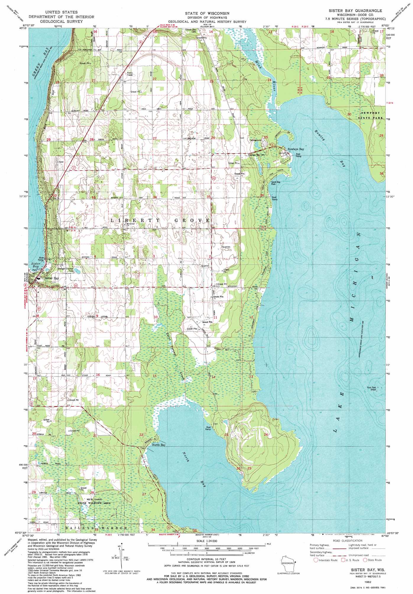
Sister Bay Topo Map Wisconsin
To zoom in, hover over the map of Sister Bay
USGS Topo Quad 45087b1 - 1:24,000 scale
| Topo Map Name: | Sister Bay |
| USGS Topo Quad ID: | 45087b1 |
| Print Size: | ca. 21 1/4" wide x 27" high |
| Southeast Coordinates: | 45.125° N latitude / 87° W longitude |
| Map Center Coordinates: | 45.1875° N latitude / 87.0625° W longitude |
| U.S. State: | WI |
| Filename: | o45087b1.jpg |
| Download Map JPG Image: | Sister Bay topo map 1:24,000 scale |
| Map Type: | Topographic |
| Topo Series: | 7.5´ |
| Map Scale: | 1:24,000 |
| Source of Map Images: | United States Geological Survey (USGS) |
| Alternate Map Versions: |
Sister Bay WI 1982, updated 1983 Download PDF Buy paper map Sister Bay WI 2010 Download PDF Buy paper map Sister Bay WI 2013 Download PDF Buy paper map Sister Bay WI 2016 Download PDF Buy paper map |
1:24,000 Topo Quads surrounding Sister Bay
Cedar River |
Washington Island Nw |
Washington Island Nw |
||
Ellison Bay |
Washington Island Sw |
Washington Island Se |
||
Chambers Island |
Ephraim |
Sister Bay |
Spider Island |
|
Egg Harbor |
Baileys Harbor West |
Baileys Harbor East |
||
Institute |
Jacksonport |
> Back to 45087a1 at 1:100,000 scale
> Back to 45086a1 at 1:250,000 scale
> Back to U.S. Topo Maps home
Sister Bay topo map: Gazetteer
Sister Bay: Airports
Hill Road Airport elevation 208m 682′Sister Bay: Bars
Four Foot Shoal elevation 177m 580′Sister Bay: Bays
North Bay elevation 177m 580′Rowley Bay elevation 177m 580′
Sand Bay elevation 177m 580′
Sister Bay elevation 177m 580′
Sister Bay: Parks
Marshall's Point State Natural Area elevation 183m 600′Mink River Estuary State Natural Area elevation 177m 580′
North Bay State Natural Area elevation 179m 587′
Sand Bay Park elevation 178m 583′
Sister Bay: Populated Places
North Bay elevation 177m 580′Rowleys Bay elevation 180m 590′
Sister Bay elevation 189m 620′
Sister Bay: Streams
Mink River elevation 177m 580′Three Springs Creek elevation 177m 580′
Sister Bay digital topo map on disk
Buy this Sister Bay topo map showing relief, roads, GPS coordinates and other geographical features, as a high-resolution digital map file on DVD: