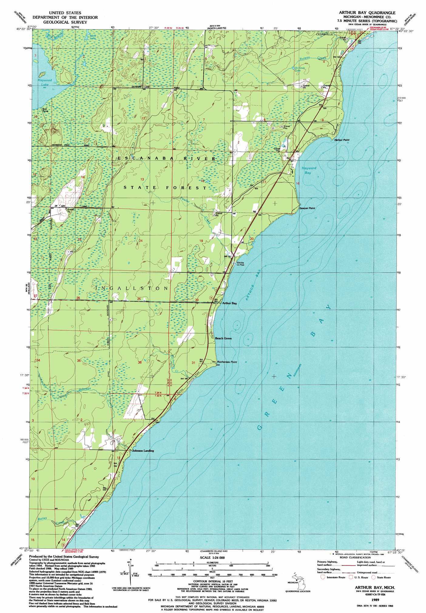
Arthur Bay Topo Map Michigan
To zoom in, hover over the map of Arthur Bay
USGS Topo Quad 45087c4 - 1:24,000 scale
| Topo Map Name: | Arthur Bay |
| USGS Topo Quad ID: | 45087c4 |
| Print Size: | ca. 21 1/4" wide x 27" high |
| Southeast Coordinates: | 45.25° N latitude / 87.375° W longitude |
| Map Center Coordinates: | 45.3125° N latitude / 87.4375° W longitude |
| U.S. State: | MI |
| Filename: | o45087c4.jpg |
| Download Map JPG Image: | Arthur Bay topo map 1:24,000 scale |
| Map Type: | Topographic |
| Topo Series: | 7.5´ |
| Map Scale: | 1:24,000 |
| Source of Map Images: | United States Geological Survey (USGS) |
| Alternate Map Versions: |
Arthur Bay MI 1989, updated 1989 Download PDF Buy paper map Arthur Bay MI 2011 Download PDF Buy paper map Arthur Bay MI 2014 Download PDF Buy paper map Arthur Bay MI 2016 Download PDF Buy paper map |
1:24,000 Topo Quads surrounding Arthur Bay
Banat |
Nadeau |
Gourley |
Bark River Se |
Henderson Lakes |
Swanson |
Stephenson |
North Lake |
Cedar River |
|
Mcallister |
Wallace |
Arthur Bay |
||
Chappee Rapids |
Birch Creek |
Chambers Island Nw |
Chambers Island |
Ephraim |
Marinette West |
Marinette East |
Green Island |
Egg Harbor |
Baileys Harbor West |
> Back to 45087a1 at 1:100,000 scale
> Back to 45086a1 at 1:250,000 scale
> Back to U.S. Topo Maps home
Arthur Bay topo map: Gazetteer
Arthur Bay: Bays
Arthur Bay elevation 176m 577′Hayward Bay elevation 176m 577′
Arthur Bay: Capes
Harbor Point elevation 179m 587′Rochereau Point elevation 177m 580′
Sawyer Point elevation 177m 580′
Arthur Bay: Lakes
Richardt Lake elevation 186m 610′Arthur Bay: Parks
Bailey County Park elevation 176m 577′Kleinke County Park elevation 179m 587′
Arthur Bay: Populated Places
Arthur Bay elevation 177m 580′Beach Grove elevation 178m 583′
Johnson Landing elevation 176m 577′
Arthur Bay: Post Offices
Arthur Bay Post Office (historical) elevation 177m 580′Arthur Bay: Streams
Bailey Creek elevation 176m 577′Fowler Creek elevation 176m 577′
Johnson Creek elevation 176m 577′
Rochereau Creek elevation 176m 577′
Ruleau Creek elevation 177m 580′
Arthur Bay digital topo map on disk
Buy this Arthur Bay topo map showing relief, roads, GPS coordinates and other geographical features, as a high-resolution digital map file on DVD: