Vulcan Topo Map Michigan
To zoom in, hover over the map of Vulcan
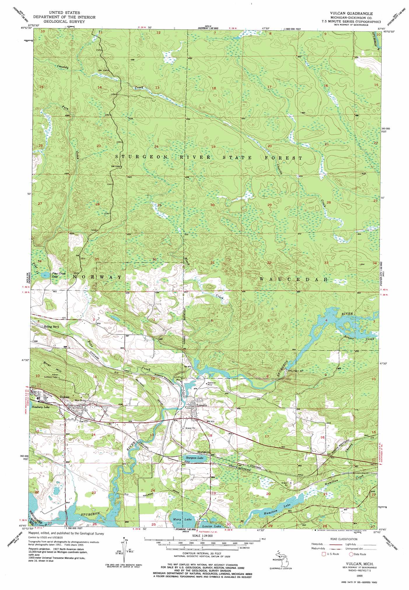
USGS Topo Quad 45087g7 - 1:24,000 scale
| Topo Map Name: | Vulcan |
| USGS Topo Quad ID: | 45087g7 |
| Print Size: | ca. 21 1/4" wide x 27" high |
| Southeast Coordinates: | 45.75° N latitude / 87.75° W longitude |
| Map Center Coordinates: | 45.8125° N latitude / 87.8125° W longitude |
| U.S. States: | MI, WI |
| Filename: | o45087g7.jpg |
| Download Map JPG Image: | Vulcan topo map 1:24,000 scale |
| Map Type: | Topographic |
| Topo Series: | 7.5´ |
| Map Scale: | 1:24,000 |
| Source of Map Images: | United States Geological Survey (USGS) |
| Alternate Map Versions: |
Vulcan MI 1955, updated 1957 Download PDF Buy paper map Vulcan MI 1955, updated 1978 Download PDF Buy paper map Vulcan MI 2011 Download PDF Buy paper map Vulcan MI 2014 Download PDF Buy paper map Vulcan MI 2016 Download PDF Buy paper map |
1:24,000 Topo Quads surrounding Vulcan
Sagola |
Ralph Sw |
Ralph |
Alfred |
Northland |
Randville |
Carney Lake |
Felch |
Foster City |
Helps |
Iron Mountain |
Norway |
Vulcan |
Waucedah |
Vega |
Dunbar Ne |
Pembine |
Faithorn |
Cunard |
Hermansville |
Town Corner Lake |
Amberg |
Miscauno Island |
Banat |
Nadeau |
> Back to 45087e1 at 1:100,000 scale
> Back to 45086a1 at 1:250,000 scale
> Back to U.S. Topo Maps home
Vulcan topo map: Gazetteer
Vulcan: Falls
Power Dam Falls elevation 283m 928′Vulcan: Lakes
Hamilton Lake elevation 260m 853′Louise Lake elevation 257m 843′
Mary Lake elevation 258m 846′
Pine Creek Lake elevation 280m 918′
Vulcan: Mines
Appleton Mine elevation 268m 879′Iron Mountain Iron Mine elevation 297m 974′
Loretto Mine elevation 268m 879′
Vulcan: Populated Places
Loretto elevation 274m 898′Vulcan elevation 291m 954′
Vulcan: Post Offices
Loretto Post Office (historical) elevation 274m 898′Vulcan Post Office elevation 292m 958′
Vulcan: Streams
Beaver Creek elevation 286m 938′Black Creek elevation 264m 866′
Cheney Creek elevation 262m 859′
Hamilton Creek elevation 252m 826′
Pine Creek elevation 263m 862′
Sturgeon River elevation 252m 826′
Vulcan: Summits
Brier Hill elevation 404m 1325′Vulcan digital topo map on disk
Buy this Vulcan topo map showing relief, roads, GPS coordinates and other geographical features, as a high-resolution digital map file on DVD: