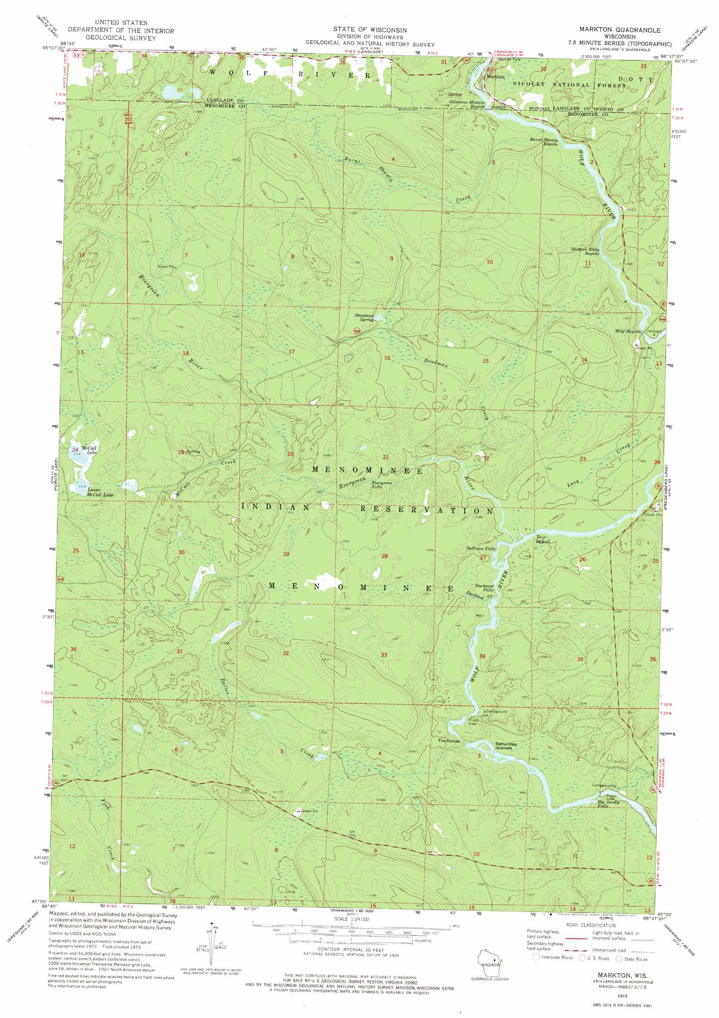
Markton Topo Map Wisconsin
To zoom in, hover over the map of Markton
USGS Topo Quad 45088a6 - 1:24,000 scale
| Topo Map Name: | Markton |
| USGS Topo Quad ID: | 45088a6 |
| Print Size: | ca. 21 1/4" wide x 27" high |
| Southeast Coordinates: | 45° N latitude / 88.625° W longitude |
| Map Center Coordinates: | 45.0625° N latitude / 88.6875° W longitude |
| U.S. State: | WI |
| Filename: | o45088a6.jpg |
| Download Map JPG Image: | Markton topo map 1:24,000 scale |
| Map Type: | Topographic |
| Topo Series: | 7.5´ |
| Map Scale: | 1:24,000 |
| Source of Map Images: | United States Geological Survey (USGS) |
| Alternate Map Versions: |
Markton WI 1973, updated 1977 Download PDF Buy paper map Markton WI 2011 Download PDF Buy paper map Markton WI 2013 Download PDF Buy paper map Markton WI 2015 Download PDF Buy paper map |
| FStopo: | US Forest Service topo Markton is available: Download FStopo PDF Download FStopo TIF |
1:24,000 Topo Quads surrounding Markton
Pickerel |
Lily |
Reservoir Pond |
Townsend |
Wheeler Lake |
Polar |
White Lake |
Langlade |
Shadow Lake |
Mountain |
Zoar |
Perote Lake |
Markton |
Fredenberg Lake |
Breed |
Burney Lake |
Neopit |
Keshena |
Legend Lake |
Berry Lake |
Bowler |
Gresham |
Thornton |
Shawano |
Cecil |
> Back to 45088a1 at 1:100,000 scale
> Back to 45088a1 at 1:250,000 scale
> Back to U.S. Topo Maps home
Markton topo map: Gazetteer
Markton: Falls
Big Smoky Falls elevation 275m 902′Ducknest Falls elevation 293m 961′
Evergreen Falls elevation 308m 1010′
Sullivan Falls elevation 297m 974′
Markton: Islands
Saturday Islands elevation 280m 918′Markton: Lakes
Lower McCall Lake elevation 341m 1118′McCall Lake elevation 340m 1115′
Markton: Populated Places
Markton elevation 329m 1079′Markton: Rapids
Burnt Shanty Rapids elevation 322m 1056′Gilmores Mistake Rapids elevation 328m 1076′
Shotgun Eddy Rapids elevation 313m 1026′
The Dalles elevation 293m 961′
Trip Rapids elevation 299m 980′
Wolf Rapids elevation 305m 1000′
Markton: Springs
Deadman Spring elevation 334m 1095′Markton: Streams
Burnt Shanty Creek elevation 322m 1056′Dalles Creek elevation 282m 925′
Deadman Creek elevation 302m 990′
Ducknest Creek elevation 292m 958′
Evergreen River elevation 298m 977′
Lazy Creek elevation 299m 980′
McCall Creek elevation 321m 1053′
Markton digital topo map on disk
Buy this Markton topo map showing relief, roads, GPS coordinates and other geographical features, as a high-resolution digital map file on DVD: