Langlade Topo Map Wisconsin
To zoom in, hover over the map of Langlade
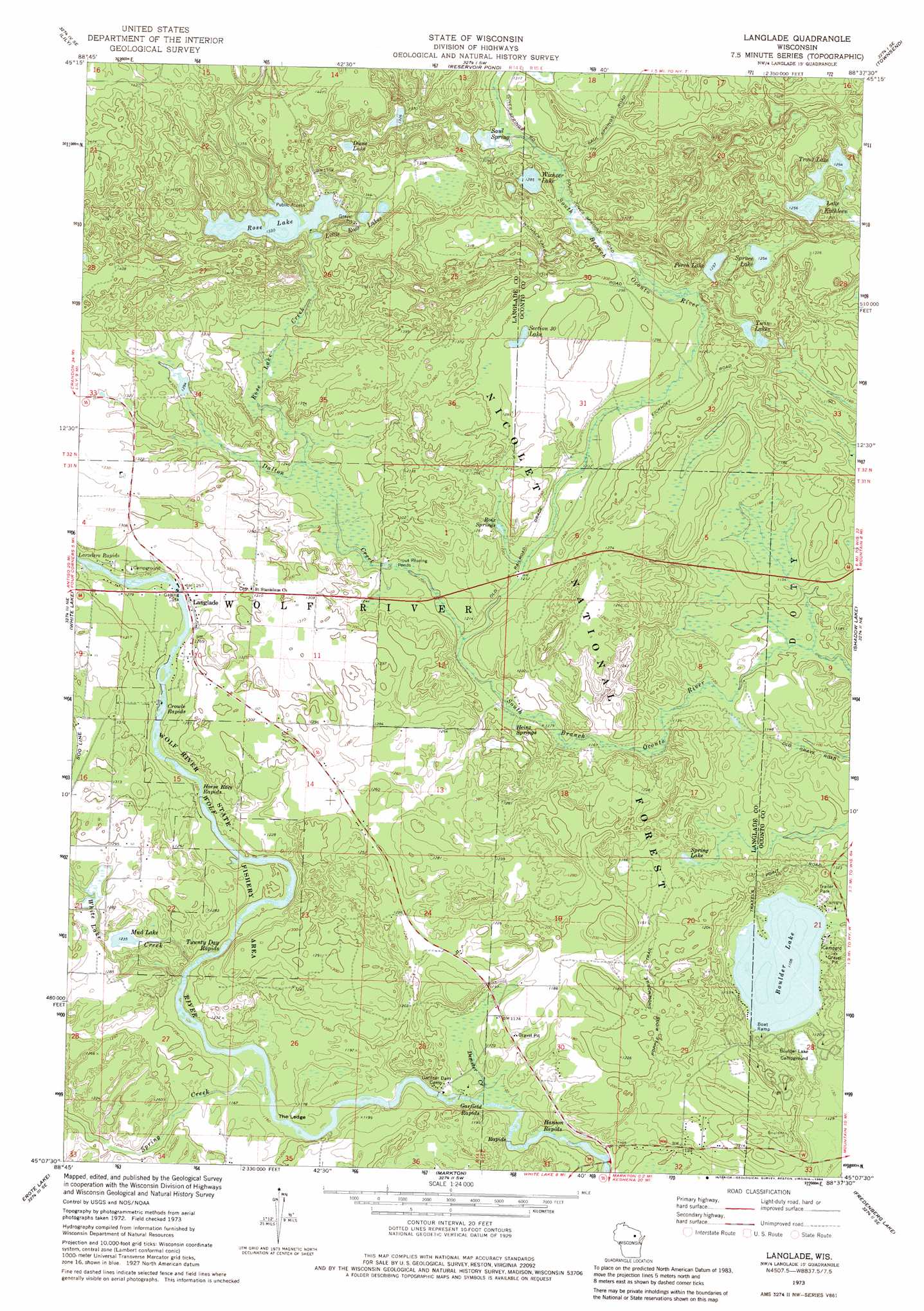
USGS Topo Quad 45088b6 - 1:24,000 scale
| Topo Map Name: | Langlade |
| USGS Topo Quad ID: | 45088b6 |
| Print Size: | ca. 21 1/4" wide x 27" high |
| Southeast Coordinates: | 45.125° N latitude / 88.625° W longitude |
| Map Center Coordinates: | 45.1875° N latitude / 88.6875° W longitude |
| U.S. State: | WI |
| Filename: | o45088b6.jpg |
| Download Map JPG Image: | Langlade topo map 1:24,000 scale |
| Map Type: | Topographic |
| Topo Series: | 7.5´ |
| Map Scale: | 1:24,000 |
| Source of Map Images: | United States Geological Survey (USGS) |
| Alternate Map Versions: |
Langlade WI 1973, updated 1977 Download PDF Buy paper map Langlade WI 1973, updated 1984 Download PDF Buy paper map Langlade WI 2011 Download PDF Buy paper map Langlade WI 2013 Download PDF Buy paper map Langlade WI 2015 Download PDF Buy paper map |
| FStopo: | US Forest Service topo Langlade is available: Download FStopo PDF Download FStopo TIF |
1:24,000 Topo Quads surrounding Langlade
Mole Lake |
Roberts Lake |
Wabeno |
Otter Lake |
Mccaslin Mountain |
Pickerel |
Lily |
Reservoir Pond |
Townsend |
Wheeler Lake |
Polar |
White Lake |
Langlade |
Shadow Lake |
Mountain |
Zoar |
Perote Lake |
Markton |
Fredenberg Lake |
Breed |
Burney Lake |
Neopit |
Keshena |
Legend Lake |
Berry Lake |
> Back to 45088a1 at 1:100,000 scale
> Back to 45088a1 at 1:250,000 scale
> Back to U.S. Topo Maps home
Langlade topo map: Gazetteer
Langlade: Cliffs
The Ledge elevation 350m 1148′Langlade: Lakes
Boulder Lake elevation 337m 1105′Diene Lake elevation 405m 1328′
Lake Kathleen elevation 383m 1256′
Little Rose Lakes elevation 407m 1335′
Mud Lake elevation 376m 1233′
Perch Lake elevation 383m 1256′
Rose Lake elevation 405m 1328′
Section Thirty Lake elevation 390m 1279′
Spring Lake elevation 347m 1138′
Spruce Lake elevation 382m 1253′
Trout Lake elevation 382m 1253′
Twin Lakes elevation 383m 1256′
Wichser Lake elevation 392m 1286′
Langlade: Populated Places
Langlade elevation 384m 1259′Langlade: Post Offices
Marktown Post Office (historical) elevation 357m 1171′Langlade: Rapids
Crowle Rapids elevation 377m 1236′Garfield Rapids elevation 341m 1118′
Hanson Rapids elevation 331m 1085′
Horse Race Rapids elevation 367m 1204′
Twenty Day Rapids elevation 356m 1167′
Langlade: Springs
Heinz Springs elevation 360m 1181′Roix Springs elevation 371m 1217′
Saul Spring elevation 394m 1292′
Langlade: Streams
Dalton Creek elevation 363m 1190′Demster Creek elevation 341m 1118′
Rose Lake Creek elevation 376m 1233′
Spring Creek elevation 351m 1151′
White Lake Creek elevation 355m 1164′
Langlade: Trails
Popple Ridge Snowmobile Trail elevation 368m 1207′Langlade digital topo map on disk
Buy this Langlade topo map showing relief, roads, GPS coordinates and other geographical features, as a high-resolution digital map file on DVD: